خانه / مشخصات زلزله
Magnitude |
:2.5 |
| Date & Time (UTC) | 2018-12-07 06:04:05.3 |
| Date & Time (Local) | 1397/9/16 09:34:05.3 |
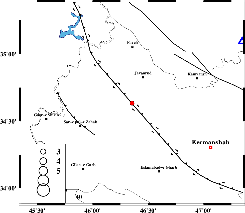
| Location | Lat:34.635 Lon: 46.355 |
| Region | Kermanshah Province, 23 km South-West of Javanrud |
Nearest Cities |
|
| 7 km of Mirabad, Kermanshah Province | |
| 12 km West of Dolatabad, Kermanshah Province | |
| 16 km North of Zavleh olia, Kermanshah Province | |
| 16 km South of Sarukhan, Kermanshah Province | |
| 20 km East of Qolqoleh, Kermanshah Province | |
| Depth | 14 km |
| Agency | |
Faults within 150 km: |
|
| HZF4 (Length: 492 km) , Distance to epicenter: 8 km | |
| MFF8 (Length: 48 km) , Distance to epicenter: 40 km | |
| SARTAKHT_F (Length: 78 km) , Distance to epicenter: 53 km | |
| Number of Phases | 7 |
| RMS | 0.2 |
| Number of Stations | 5 |
| Error in Latitude | >2.1 km |
| Error in Longitude | 2.6 km |
| Error in Depth | 6.2 km |
Download waveform in seisan format
to download seisan software Click here
to access information about IIEES stations Click here
Amplitude | ||||||||
| UID | Agency | Station | Component | Amplitude | Period | Arrival Time | Proccessing Time | Signal Clip |
| 139197 | IIEES | ILBA | N | 115.6 | 0.3 | 2018-12-07 06:04:45 | 2018-12-10 11:10:00 | n |
| 139198 | IIEES | ILBA | E | 87.3 | 0.35 | 2018-12-07 06:04:46 | 2018-12-10 11:10:00 | n |
| 139199 | IIEES | SRSL | E | 52.3 | 0.53 | 2018-12-07 06:05:06 | 2018-12-10 11:10:00 | n |
| 139200 | IIEES | SRSL | N | 54.5 | 0.48 | 2018-12-07 06:05:09 | 2018-12-10 11:10:00 | n |
Phase | ||||||||||||
| Agency | Station | Component | Phase Type | Phase Quality | First Motion | Observed Arrival Time | Time Residual | Loc. Flag | Input Weight | Distance | Azimuth | |
| IIEES | SNGE | Z | Pg | E | 2018-12-07 06:04:22 | -0.42 | y | 104 | 60 | |||
| IIEES | SNGE | N | Sg | E | 2018-12-07 06:04:36 | 0.04 | y | 104 | 60 | |||
| IIEES | ILBA | Z | Pg | E | 2018-12-07 06:04:24 | -0.1 | y | 113 | 187 | |||
| IIEES | SRSL | Z | Pg | E | 2018-12-07 06:04:37 | -0.06 | y | 194 | 335 | |||
| IIEES | SRSL | N | Sg | E | 2018-12-07 06:05:00 | 0.1 | y | 194 | 335 | |||
| IIEES | ASAO | Z | Pn | E | 2018-12-07 06:04:55 | 0.41 | y | 337 | 91 | |||
| IIEES | KHMZ | Z | Pn | E | 2018-12-07 06:04:56 | 0.09 | y | 347 | 106 | |||
کلیه حقوق مادی و معنوی این سایت متعلق به پژوهشگاه بین المللی زلزله شناسی و مهندسی زلزله می باشد.
