خانه / مشخصات زلزله
Magnitude |
:2.8 |
| Date & Time (UTC) | 2018-12-14 01:51:39.8 |
| Date & Time (Local) | 1397/9/23 05:21:39.8 |
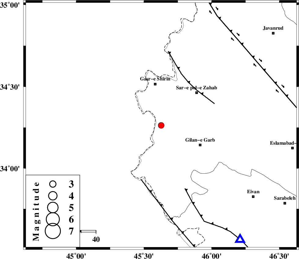
| Location | Lat:34.263 Lon: 45.627 |
| Region | Kermanshah Province, 28 km South of Qasr-E-Shirin |
Nearest Cities |
|
| 20 km South of Seyyed sohrab, Kermanshah Province | |
| 21 km South East of Khosravi, Kermanshah Province | |
| 22 km West of Chub baghan, Kermanshah Province | |
| 28 km South West of Qareh belagh, Kermanshah Province | |
| 28 km South of Qasr-E-Shirin, Kermanshah Province | |
| Depth | 14 km |
| Agency | |
Faults within 150 km: |
|
| MFF8 (Length: 48 km) , Distance to epicenter: 34 km | |
| ZFF4 (Length: 128 km) , Distance to epicenter: 39 km | |
| MFF7 (Length: 99 km) , Distance to epicenter: 46 km | |
| Number of Phases | 7 |
| RMS | 0.3 |
| Number of Stations | 5 |
| Error in Latitude | >2.4 km |
| Error in Longitude | 4.1 km |
| Error in Depth | 5.7 km |
Download waveform in seisan format
to download seisan software Click here
to access information about IIEES stations Click here
Amplitude | ||||||||
| UID | Agency | Station | Component | Amplitude | Period | Arrival Time | Proccessing Time | Signal Clip |
| 139400 | IIEES | ILBA | N | 281.1 | 0.31 | 2018-12-14 01:52:11 | 2018-12-17 07:22:00 | n |
| 139401 | IIEES | ILBA | E | 346.8 | 0.49 | 2018-12-14 01:52:14 | 2018-12-17 07:22:00 | n |
| 139402 | IIEES | SNGE | E | 77.9 | 0.47 | 2018-12-14 01:52:37 | 2018-12-17 07:22:00 | n |
| 139403 | IIEES | SNGE | N | 97.9 | 0.33 | 2018-12-14 01:52:37 | 2018-12-17 07:22:00 | n |
| 139404 | IIEES | SRSL | E | 150.7 | 0.45 | 2018-12-14 01:52:44 | 2018-12-17 07:22:00 | n |
| 139405 | IIEES | ASAO | E | 7 | 0.52 | 2018-12-14 01:53:44 | 2018-12-17 07:22:00 | n |
Phase | ||||||||||||
| Agency | Station | Component | Phase Type | Phase Quality | First Motion | Observed Arrival Time | Time Residual | Loc. Flag | Input Weight | Distance | Azimuth | |
| IIEES | ILBA | Z | Pg | E | 2018-12-14 01:51:54 | -0.18 | y | 88.9 | 143 | |||
| IIEES | SNGE | Z | Pg | E | 2018-12-14 01:52:09 | -0.13 | y | 183 | 59 | |||
| IIEES | SNGE | N | Sg | E | 2018-12-14 01:52:32 | -0.06 | y | 183 | 59 | |||
| IIEES | SRSL | Z | Pn | E | 2018-12-14 01:52:14 | -0.1 | y | 217 | 355 | |||
| IIEES | SRSL | N | Sg | E | 2018-12-14 01:52:41 | 0.05 | y | 217 | 355 | |||
| IIEES | ZNJK | Z | Pn | E | 2018-12-14 01:52:35 | -0.1 | y | 385 | 45 | |||
| IIEES | ASAO | Z | Pn | E | 2018-12-14 01:52:38 | 0.65 | y | 406 | 84 | |||
کلیه حقوق مادی و معنوی این سایت متعلق به پژوهشگاه بین المللی زلزله شناسی و مهندسی زلزله می باشد.
