خانه / مشخصات زلزله
Magnitude |
:3.6 |
| Date & Time (UTC) | 2018-12-22 05:21:32.5 |
| Date & Time (Local) | 1397/10/1 08:51:32.5 |
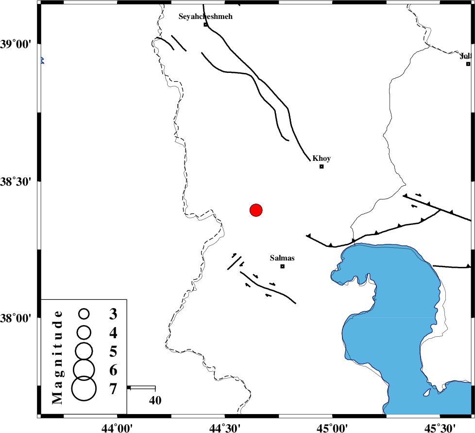
| Location | Lat:38.394 Lon: 44.644 |
| Region | Azarbaijan Gharbi Province, 25 km North-West of Salmas |
Nearest Cities |
|
| 13 km North West of Saylab, Azarbaijan Gharbi Province | |
| 22 km South West of Beyk sofla, Azarbaijan Gharbi Province | |
| 22 km East of Gatur, Azarbaijan Gharbi Province | |
| 25 km West of Quruq, Azarbaijan Gharbi Province | |
| 25 km North West of Salmas, Azarbaijan Gharbi Province | |
| Depth | 14 km |
| Agency | |
Faults within 150 km: |
|
| SALMAS (Length: 20 km) , Distance to epicenter: 20 km | |
| N_TABRIZ_F3 (Length: 66 km) , Distance to epicenter: 23 km | |
| KHOY (Length: 100 km) , Distance to epicenter: 30 km | |
| Number of Phases | 7 |
| RMS | 0.3 |
| Number of Stations | 5 |
| Error in Latitude | >2.3 km |
| Error in Longitude | 4.8 km |
| Error in Depth | 6.5 km |
Download waveform in seisan format
to download seisan software Click here
to access information about IIEES stations Click here
Amplitude | ||||||||
| UID | Agency | Station | Component | Amplitude | Period | Arrival Time | Proccessing Time | Signal Clip |
| 139538 | IIEES | SRSL | N | 221.9 | 0.65 | 2018-12-22 05:22:52 | 2018-12-22 09:58:00 | n |
| 139539 | IIEES | ILBA | N | 41.2 | 0.79 | 2018-12-22 05:24:23 | 2018-12-22 09:58:00 | n |
| 139540 | IIEES | ILBA | E | 31 | 0.63 | 2018-12-22 05:24:31 | 2018-12-22 09:58:00 | n |
Phase | ||||||||||||
| Agency | Station | Component | Phase Type | Phase Quality | First Motion | Observed Arrival Time | Time Residual | Loc. Flag | Input Weight | Distance | Azimuth | |
| IIEES | MAKU | Z | Pg | E | 2018-12-22 05:21:50 | -0.2 | y | 107 | 2 | |||
| IIEES | SRSL | Z | Pn | E | 2018-12-22 05:22:11 | 0.29 | y | 252 | 164 | |||
| IIEES | SRSL | N | Sg | E | 2018-12-22 05:22:43 | -0.45 | y | 252 | 164 | |||
| IIEES | GRMI | Z | Pn | E | 2018-12-22 05:22:15 | -0.21 | y | 287 | 80 | |||
| IIEES | GRMI | N | Sg | E | 2018-12-22 05:22:53 | 0.14 | y | 287 | 80 | |||
| IIEES | SNGE | Z | Pn | E | 2018-12-22 05:22:34 | 0.17 | y | 439 | 146 | |||
| IIEES | ILBA | Z | Pn | E | 2018-12-22 05:22:48 | 0.48 | y | 548 | 165 | |||
کلیه حقوق مادی و معنوی این سایت متعلق به پژوهشگاه بین المللی زلزله شناسی و مهندسی زلزله می باشد.
