خانه / مشخصات زلزله
Magnitude |
:3.3 |
| Date & Time (UTC) | 2019-01-04 15:16:45.9 |
| Date & Time (Local) | 1397/10/14 18:46:45.9 |
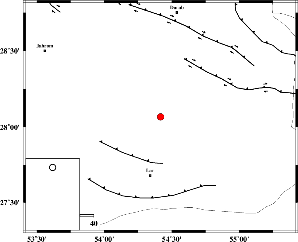
| Location | Lat:28.066 Lon: 54.417 |
| Region | Fars Province, 44 km North of Lar |
Nearest Cities |
|
| 24 km North of Dehkuyeh, Fars Province | |
| 28 km South of Shahr-e pir, Fars Province | |
| 32 km South of Hajiabad, Fars Province | |
| 41 km North of Latifi, Fars Province | |
| 44 km South East of Dabiran, Fars Province | |
| Depth | 16 km |
| Agency | |
Faults within 150 km: |
|
| BERIZ_F (Length: 49 km) , Distance to epicenter: 34 km | |
| HZF2 (Length: 437 km) , Distance to epicenter: 46 km | |
| LAR_F (Length: 99 km) , Distance to epicenter: 58 km | |
| Number of Phases | 7 |
| RMS | 0.4 |
| Number of Stations | 6 |
| Error in Latitude | >3.8 km |
| Error in Longitude | 4.3 km |
| Error in Depth | 7.8 km |
Download waveform in seisan format
to download seisan software Click here
to access information about IIEES stations Click here
Amplitude | ||||||||
| UID | Agency | Station | Component | Amplitude | Period | Arrival Time | Proccessing Time | Signal Clip |
| 139809 | IIEES | GHIR | N | 471.5 | 0.37 | 2019-01-04 15:17:40 | 2019-01-05 10:36:00 | n |
| 139810 | IIEES | BNDS | E | 376 | 0.22 | 2019-01-04 15:17:52 | 2019-01-05 10:36:00 | n |
| 139811 | IIEES | BNDS | N | 322.7 | 0.5 | 2019-01-04 15:18:03 | 2019-01-05 10:36:00 | n |
| 139812 | IIEES | YZKH | N | 13.7 | 0.51 | 2019-01-04 15:19:14 | 2019-01-05 10:36:00 | n |
| 139813 | IIEES | TABS | N | 5.6 | 0.74 | 2019-01-04 15:20:12 | 2019-01-05 10:36:00 | n |
Phase | ||||||||||||
| Agency | Station | Component | Phase Type | Phase Quality | First Motion | Observed Arrival Time | Time Residual | Loc. Flag | Input Weight | Distance | Azimuth | |
| IIEES | GHIR | Z | Pg | E | 2019-01-04 15:17:09 | 0.11 | y | 143 | 280 | |||
| IIEES | BNDS | Z | Pg | E | 2019-01-04 15:17:16 | -0.16 | y | 188 | 113 | |||
| IIEES | KRBR | Z | Pn | E | 2019-01-04 15:17:32 | 0.53 | y | 312 | 47 | |||
| IIEES | YZKH | Z | Pn | E | 2019-01-04 15:17:52 | -0.38 | y | 480 | 2 | |||
| IIEES | YZKH | E | Sg | E | 2019-01-04 15:18:59 | 0.07 | y | 480 | 2 | |||
| IIEES | ZHSF | Z | Pn | E | 2019-01-04 15:18:13 | 0.21 | y | 644 | 73 | |||
| IIEES | TABS | Z | Pn | E | 2019-01-04 15:18:16 | -0.68 | y | 671 | 22 | |||
کلیه حقوق مادی و معنوی این سایت متعلق به پژوهشگاه بین المللی زلزله شناسی و مهندسی زلزله می باشد.
