خانه / مشخصات زلزله
Magnitude |
:2.7 |
| Date & Time (UTC) | 2019-01-08 11:45:21.2 |
| Date & Time (Local) | 1397/10/18 15:15:21.2 |
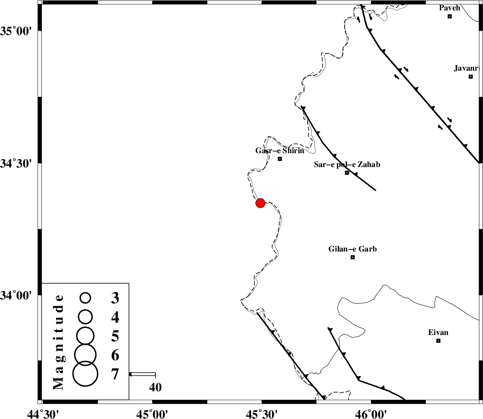
| Location | Lat:34.349 Lon: 45.493 |
| Region | Kermanshah Province, 20 km South of Qasr-E-Shirin |
Nearest Cities |
|
| 6 km of Khosravi, Kermanshah Province | |
| 14 km West of Seyyed sohrab, Kermanshah Province | |
| 20 km South of Qasr-E-Shirin, Kermanshah Province | |
| 27 km South West of Aqabarar, Kermanshah Province | |
| 30 km South West of Qareh belagh, Kermanshah Province | |
| Depth | 14 km |
| Agency | |
Faults within 150 km: |
|
| MFF8 (Length: 48 km) , Distance to epicenter: 36 km | |
| ZFF4 (Length: 128 km) , Distance to epicenter: 46 km | |
| MFF7 (Length: 99 km) , Distance to epicenter: 60 km | |
| Number of Phases | 5 |
| RMS | 0.2 |
| Number of Stations | 3 |
| Error in Latitude | >2.1 km |
| Error in Longitude | 3.9 km |
| Error in Depth | 7.4 km |
Download waveform in seisan format
to download seisan software Click here
to access information about IIEES stations Click here
Amplitude | ||||||||
| UID | Agency | Station | Component | Amplitude | Period | Arrival Time | Proccessing Time | Signal Clip |
| 139971 | IIEES | ILBA | N | 239.3 | 0.41 | 2019-01-08 11:45:58 | 2019-01-09 07:04:00 | n |
| 139972 | IIEES | ILBA | E | 220.1 | 0.46 | 2019-01-08 11:45:59 | 2019-01-09 07:04:00 | n |
| 139973 | IIEES | SNGE | E | 66.5 | 0.44 | 2019-01-08 11:46:19 | 2019-01-09 07:04:00 | n |
| 139974 | IIEES | SNGE | N | 87.1 | 0.66 | 2019-01-08 11:46:20 | 2019-01-09 07:04:00 | n |
| 139975 | IIEES | SRSL | E | 100.5 | 0.54 | 2019-01-08 11:46:29 | 2019-01-09 07:04:00 | n |
| 139976 | IIEES | SRSL | N | 63.5 | 0.54 | 2019-01-08 11:46:33 | 2019-01-09 07:04:00 | n |
Phase | ||||||||||||
| Agency | Station | Component | Phase Type | Phase Quality | First Motion | Observed Arrival Time | Time Residual | Loc. Flag | Input Weight | Distance | Azimuth | |
| IIEES | ILBA | Z | Pg | E | 2019-01-08 11:45:38 | -0.1 | y | 104 | 140 | |||
| IIEES | SNGE | Z | Pg | E | 2019-01-08 11:45:52 | -0.12 | y | 189 | 64 | |||
| IIEES | SNGE | N | Sg | E | 2019-01-08 11:46:15 | 0.11 | y | 189 | 64 | |||
| IIEES | SRSL | Z | Pn | E | 2019-01-08 11:45:55 | 0.32 | y | 207 | 359 | |||
| IIEES | SRSL | N | Sg | E | 2019-01-08 11:46:19 | -0.21 | y | 207 | 359 | |||
کلیه حقوق مادی و معنوی این سایت متعلق به پژوهشگاه بین المللی زلزله شناسی و مهندسی زلزله می باشد.
