خانه / مشخصات زلزله
Magnitude |
:3 |
| Date & Time (UTC) | 2019-01-20 09:34:08.2 |
| Date & Time (Local) | 1397/10/30 13:04:08.2 |
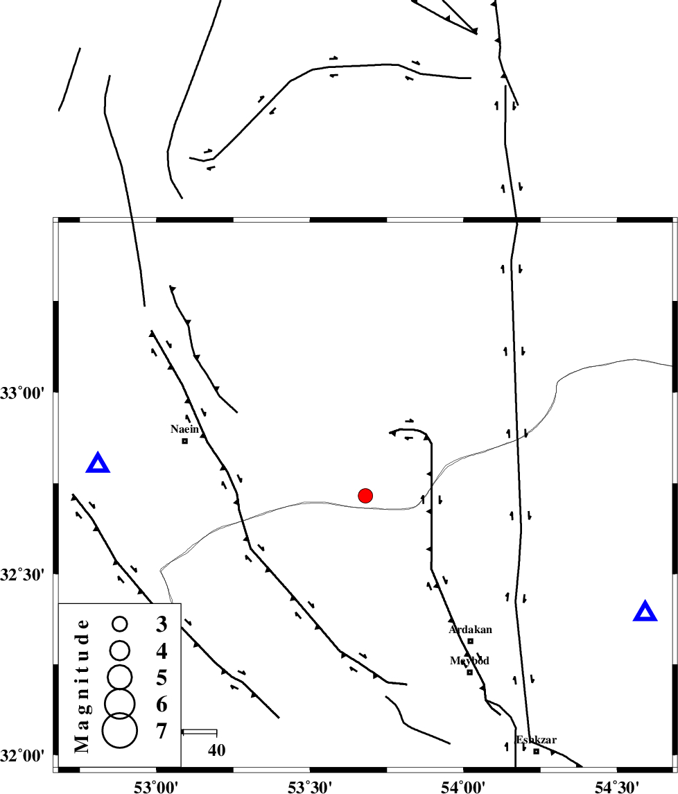
| Location | Lat:32.715 Lon: 53.68 |
| Region | Esfahan Province, 57 km South-East of Nain |
Nearest Cities |
|
| 30 km North of Eqda, Yazd Province | |
| 52 km South East of Baferan, Esfahan Province | |
| 55 km North West of Ardakan, Yazd Province | |
| 57 km North West of Befrueiyeh, Yazd Province | |
| 57 km South East of Nain, Esfahan Province | |
| Depth | 15 km |
| Agency | |
Faults within 150 km: |
|
| SHAHR_E_BABAK_F1 (Length: 392 km) , Distance to epicenter: 48 km | |
| BIABANAK_F (Length: 162 km) , Distance to epicenter: 48 km | |
| CHAH_ZANGUL_F (Length: 123 km) , Distance to epicenter: 54 km | |
| Number of Phases | 6 |
| RMS | 0.2 |
| Number of Stations | 6 |
| Error in Latitude | >9.5 km |
| Error in Longitude | 1.3 km |
| Error in Depth | 0 km |
Download waveform in seisan format
to download seisan software Click here
to access information about IIEES stations Click here
Amplitude | ||||||||
| UID | Agency | Station | Component | Amplitude | Period | Arrival Time | Proccessing Time | Signal Clip |
| 140430 | IIEES | NASN | N | 545.1 | 0.18 | 2019-01-20 09:34:26 | 2019-01-20 10:25:00 | n |
| 140431 | IIEES | GHVR | N | 48.6 | 0.28 | 2019-01-20 09:35:36 | 2019-01-20 10:25:00 | n |
| 140432 | IIEES | GHVR | E | 47.9 | 0.45 | 2019-01-20 09:35:42 | 2019-01-20 10:25:00 | n |
Phase | ||||||||||||
| Agency | Station | Component | Phase Type | Phase Quality | First Motion | Observed Arrival Time | Time Residual | Loc. Flag | Input Weight | Distance | Azimuth | |
| IIEES | NASN | Z | Pg | E | 2019-01-20 09:34:17 | -4.64 | n | 4 | 82.2 | 277 | ||
| IIEES | GHVR | Z | Pn | E | 2019-01-20 09:34:52 | -0.25 | y | 299 | 312 | |||
| IIEES | TABS | Z | Pn | E | 2019-01-20 09:34:57 | 0.19 | y | 337 | 71 | |||
| IIEES | KHMZ | Z | Pn | E | 2019-01-20 09:35:01 | 0.17 | y | 365 | 289 | |||
| IIEES | ASAO | Z | Pn | E | 2019-01-20 09:35:05 | 0.09 | y | 395 | 302 | |||
| IIEES | BSRN | Z | Pn | E | 2019-01-20 09:35:20 | -0.22 | y | 519 | 98 | |||
کلیه حقوق مادی و معنوی این سایت متعلق به پژوهشگاه بین المللی زلزله شناسی و مهندسی زلزله می باشد.
