خانه / مشخصات زلزله
Magnitude |
:3 |
| Date & Time (UTC) | 2019-01-28 05:16:08.2 |
| Date & Time (Local) | 1397/11/8 08:46:08.2 |
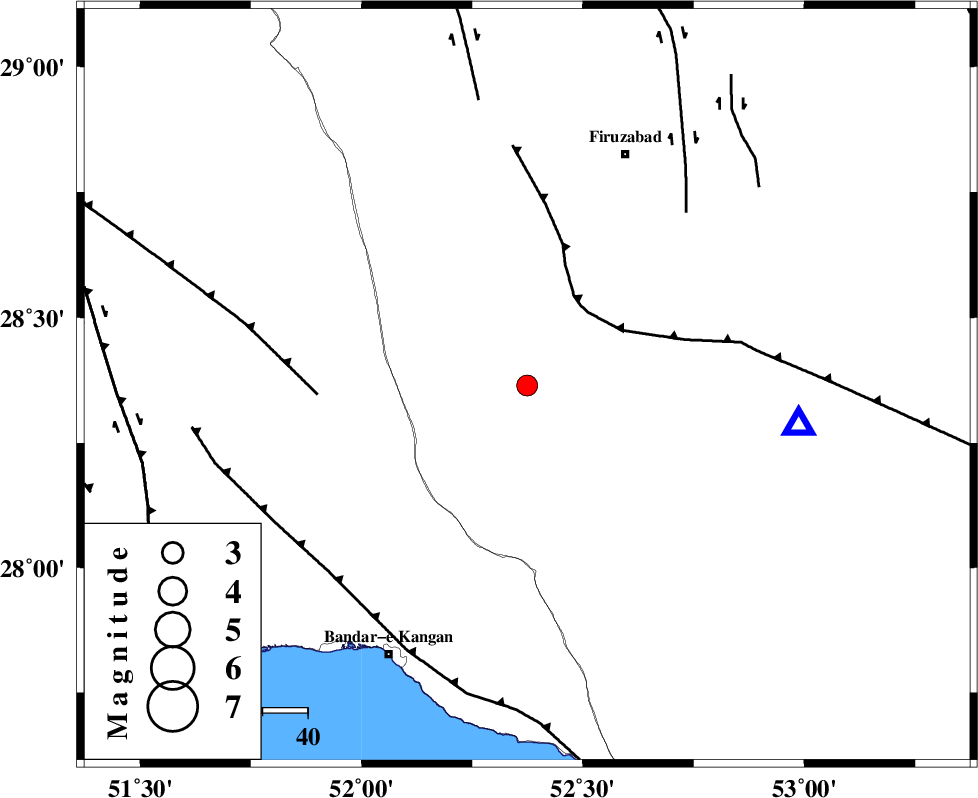
| Location | Lat:28.365 Lon: 52.374 |
| Region | Fars Province, 59 km North of Jam |
Nearest Cities |
|
| 15 km South of Dahrom, Fars Province | |
| 25 km North of Dolatabad, Fars Province | |
| 27 km West of Hengam, Fars Province | |
| 46 km North East of Riz, Bushehr Province | |
| 51 km South West of Jaydasht, Fars Province | |
| Depth | 18 km |
| Agency | |
Faults within 150 km: |
|
| QIR_F (Length: 130 km) , Distance to epicenter: 21 km | |
| MFF5 (Length: 74 km) , Distance to epicenter: 46 km | |
| SABZ_PUSHAN_F_Z1 (Length: 69 km) , Distance to epicenter: 52 km | |
| Number of Phases | 5 |
| RMS | 0 |
| Number of Stations | 3 |
| Error in Latitude | >8.8 km |
| Error in Longitude | 4.1 km |
| Error in Depth | 7.3 km |
Download waveform in seisan format
to download seisan software Click here
to access information about IIEES stations Click here
Amplitude | ||||||||
| UID | Agency | Station | Component | Amplitude | Period | Arrival Time | Proccessing Time | Signal Clip |
| 140630 | IIEES | GHIR | N | 748.3 | 0.39 | 2019-01-28 05:16:36 | 2019-01-30 08:05:00 | n |
| 140631 | IIEES | AHRM | N | 462.4 | 0.41 | 2019-01-28 05:16:47 | 2019-01-30 08:05:00 | n |
Phase | ||||||||||||
| Agency | Station | Component | Phase Type | Phase Quality | First Motion | Observed Arrival Time | Time Residual | Loc. Flag | Input Weight | Distance | Azimuth | |
| IIEES | GHIR | Z | Pg | E | 2019-01-28 05:16:19 | 0 | y | 60.7 | 98 | |||
| IIEES | GHIR | N | S | E | 2019-01-28 05:16:26 | 0.01 | y | 60.7 | 98 | |||
| IIEES | AHRM | Z | Pg | E | 2019-01-28 05:16:28 | -0.04 | y | 119 | 298 | |||
| IIEES | AHRM | N | Sg | E | 2019-01-28 05:16:42 | 0.03 | y | 119 | 298 | |||
| IIEES | YZKH | Z | Pn | E | 2019-01-28 05:17:17 | -0.01 | y | 494 | 25 | |||
کلیه حقوق مادی و معنوی این سایت متعلق به پژوهشگاه بین المللی زلزله شناسی و مهندسی زلزله می باشد.
