خانه / مشخصات زلزله
Magnitude |
:3.3 |
| Date & Time (UTC) | 2019-01-30 22:42:23.8 |
| Date & Time (Local) | 1397/11/11 02:12:23.8 |
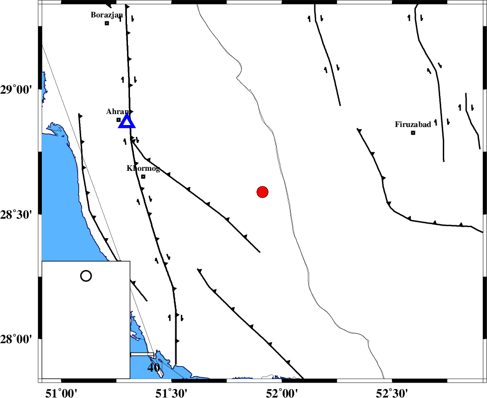
| Location | Lat:28.589 Lon: 51.912 |
| Region | Bushehr Province, 36 km South-West of Farashband |
Nearest Cities |
|
| 27 km North East of Shanbeh, Bushehr Province | |
| 36 km South West of Farashband, Fars Province | |
| 39 km South West of Aviz, Fars Province | |
| 40 km North West of Dahrom, Fars Province | |
| 46 km North East of Baduleh, Bushehr Province | |
| Depth | 15 km |
| Agency | |
Faults within 150 km: |
|
| MFF5 (Length: 74 km) , Distance to epicenter: 20 km | |
| MFF3 (Length: 292 km) , Distance to epicenter: 45 km | |
| QIR_F (Length: 130 km) , Distance to epicenter: 50 km | |
| Number of Phases | 5 |
| RMS | 0.1 |
| Number of Stations | 5 |
| Error in Latitude | >5.3 km |
| Error in Longitude | 3.5 km |
| Error in Depth | 5.4 km |
Download waveform in seisan format
to download seisan software Click here
to access information about IIEES stations Click here
Amplitude | ||||||||
| UID | Agency | Station | Component | Amplitude | Period | Arrival Time | Proccessing Time | Signal Clip |
| 140721 | IIEES | AHRM | N | 1293.8 | 0.49 | 2019-01-30 22:42:52 | 2019-02-02 08:29:00 | n |
| 140722 | IIEES | GHIR | N | 899.4 | 0.34 | 2019-01-30 22:43:04 | 2019-02-02 08:29:00 | n |
| 140723 | IIEES | BNDS | E | 25.3 | 0.46 | 2019-01-30 22:44:42 | 2019-02-02 08:29:00 | n |
| 140724 | IIEES | KRBR | E | 21.3 | 0.73 | 2019-01-30 22:45:01 | 2019-02-02 08:29:00 | n |
Phase | ||||||||||||
| Agency | Station | Component | Phase Type | Phase Quality | First Motion | Observed Arrival Time | Time Residual | Loc. Flag | Input Weight | Distance | Azimuth | |
| IIEES | AHRM | Z | Pg | E | 2019-01-30 22:42:35 | 0.02 | y | 67.5 | 297 | |||
| IIEES | GHIR | Z | Pg | E | 2019-01-30 22:42:42 | -0.02 | y | 110 | 107 | |||
| IIEES | BNDS | Z | Pn | E | 2019-01-30 22:43:26 | -0.06 | y | 439 | 106 | |||
| IIEES | YZKH | Z | Pn | E | 2019-01-30 22:43:32 | -0.12 | y | 494 | 31 | |||
| IIEES | KRBR | Z | Pn | E | 2019-01-30 22:43:33 | 0.2 | y | 496 | 71 | |||
کلیه حقوق مادی و معنوی این سایت متعلق به پژوهشگاه بین المللی زلزله شناسی و مهندسی زلزله می باشد.
