خانه / مشخصات زلزله
Magnitude |
:2.8 |
| Date & Time (UTC) | 2019-02-05 02:04:00.4 |
| Date & Time (Local) | 1397/11/16 05:34:00.4 |
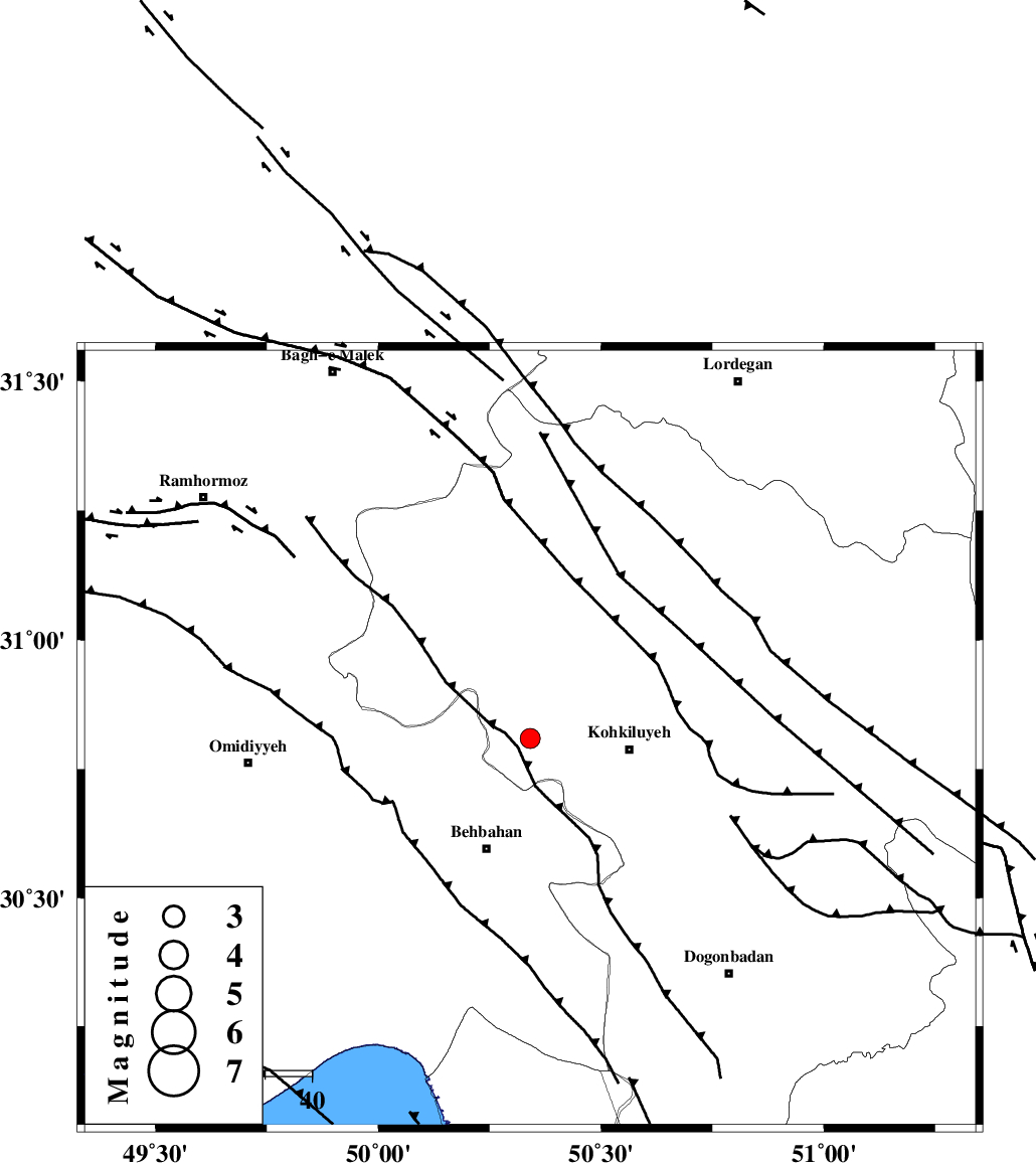
| Location | Lat:30.809 Lon: 50.341 |
| Region | Kohkiluieh va boyerahmad Province, 21 km -West of Dehdasht |
Nearest Cities |
|
| 19 km North East of Dodange-ye bozorg, Khoozestan Province | |
| 20 km North of Mansuriyeh, Khoozestan Province | |
| 21 km South of Lendeh, Kohkiluieh va boyerahmad Province | |
| 21 km North West of Dehdasht, Kohkiluieh va boyerahmad Province | |
| 25 km North of Behbahan, Khoozestan Province | |
| Depth | 15 km |
| Agency | |
Faults within 150 km: |
|
| MFF4 (Length: 62 km) , Distance to epicenter: 4 km | |
| MISHAN_F (Length: 76 km) , Distance to epicenter: 40 km | |
| AGHAJARI_F (Length: 88 km) , Distance to epicenter: 49 km | |
| Number of Phases | 6 |
| RMS | 0.1 |
| Number of Stations | 6 |
| Error in Latitude | >1.4 km |
| Error in Longitude | 1.8 km |
| Error in Depth | 0 km |
Download waveform in seisan format
to download seisan software Click here
to access information about IIEES stations Click here
Amplitude | ||||||||
| UID | Agency | Station | Component | Amplitude | Period | Arrival Time | Proccessing Time | Signal Clip |
| 140984 | IIEES | AHRM | N | 80.6 | 0.46 | 2019-02-05 02:05:17 | 2019-02-05 04:52:00 | n |
| 140985 | IIEES | ASAO | N | 8.2 | 0.34 | 2019-02-05 02:05:54 | 2019-02-05 04:52:00 | n |
| 140986 | IIEES | GHVR | N | 13.4 | 0.65 | 2019-02-05 02:05:48 | 2019-02-05 04:52:00 | n |
| 140987 | IIEES | GHVR | E | 10.6 | 0.27 | 2019-02-05 02:05:49 | 2019-02-05 04:52:00 | n |
| 140988 | IIEES | ASAO | E | 8.4 | 0.42 | 2019-02-05 02:05:46 | 2019-02-05 04:52:00 | n |
Phase | ||||||||||||
| Agency | Station | Component | Phase Type | Phase Quality | First Motion | Observed Arrival Time | Time Residual | Loc. Flag | Input Weight | Distance | Azimuth | |
| IIEES | AHRM | Z | EPn | E | 2019-02-05 02:04:37 | 0.01 | y | 234 | 157 | |||
| IIEES | NASN | Z | EPn | E | 2019-02-05 02:04:48 | 0.08 | y | 321 | 46 | |||
| IIEES | KHMZ | Z | EPn | E | 2019-02-05 02:04:48 | -0.04 | y | 327 | 354 | |||
| IIEES | ASAO | Z | EPn | E | 2019-02-05 02:04:59 | 0.04 | y | 416 | 356 | |||
| IIEES | GHVR | Z | EPn | E | 2019-02-05 02:04:59 | -0.01 | y | 416 | 12 | |||
| IIEES | YZKH | Z | EPn | E | 2019-02-05 02:05:02 | -0.08 | y | 440 | 65 | |||
کلیه حقوق مادی و معنوی این سایت متعلق به پژوهشگاه بین المللی زلزله شناسی و مهندسی زلزله می باشد.
