خانه / مشخصات زلزله
Magnitude |
:2.7 |
| Date & Time (UTC) | 2019-02-05 19:46:20.1 |
| Date & Time (Local) | 1397/11/16 23:16:20.1 |
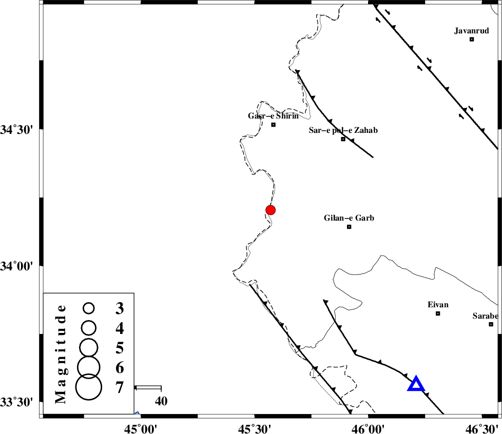
| Location | Lat:34.204 Lon: 45.57 |
| Region | Kermanshah Province, 35 km South of Qasr-E-Shirin |
Nearest Cities |
|
| 24 km South of Khosravi, Kermanshah Province | |
| 27 km South of Seyyed sohrab, Kermanshah Province | |
| 29 km South West of Chub baghan, Kermanshah Province | |
| 32 km North West of Gilan-E-Gharb, Kermanshah Province | |
| 35 km South of Qasr-E-Shirin, Kermanshah Province | |
| Depth | 15 km |
| Agency | |
Faults within 150 km: |
|
| ZFF4 (Length: 128 km) , Distance to epicenter: 31 km | |
| MFF7 (Length: 99 km) , Distance to epicenter: 42 km | |
| MFF8 (Length: 48 km) , Distance to epicenter: 42 km | |
| Number of Phases | 5 |
| RMS | 0 |
| Number of Stations | 3 |
| Error in Latitude | >1.2 km |
| Error in Longitude | 2.2 km |
| Error in Depth | 4.1 km |
Download waveform in seisan format
to download seisan software Click here
to access information about IIEES stations Click here
Amplitude | ||||||||
| UID | Agency | Station | Component | Amplitude | Period | Arrival Time | Proccessing Time | Signal Clip |
| 141049 | IIEES | SNGE | N | 66.3 | 0.37 | 2019-02-05 19:47:18 | 2019-02-06 08:14:00 | n |
| 141050 | IIEES | SNGE | E | 33.7 | 0.51 | 2019-02-05 19:47:21 | 2019-02-06 08:14:00 | n |
| 141051 | IIEES | SRSL | E | 49.6 | 0.33 | 2019-02-05 19:47:25 | 2019-02-06 08:14:00 | n |
| 141052 | IIEES | SRSL | N | 101.3 | 0.38 | 2019-02-05 19:47:26 | 2019-02-06 08:14:00 | n |
Phase | ||||||||||||
| Agency | Station | Component | Phase Type | Phase Quality | First Motion | Observed Arrival Time | Time Residual | Loc. Flag | Input Weight | Distance | Azimuth | |
| IIEES | ILBA | Z | EPg | E | 2019-02-05 19:46:35 | 0 | y | 87.2 | 137 | |||
| IIEES | SNGE | Z | EPg | E | 2019-02-05 19:46:51 | 0.01 | y | 190 | 58 | |||
| IIEES | SNGE | N | ESg | E | 2019-02-05 19:47:14 | 0 | y | 190 | 58 | |||
| IIEES | SRSL | Z | EPn | E | 2019-02-05 19:46:55 | -0.01 | y | 223 | 357 | |||
| IIEES | SRSL | N | ESg | E | 2019-02-05 19:47:23 | 0.01 | y | 223 | 357 | |||
کلیه حقوق مادی و معنوی این سایت متعلق به پژوهشگاه بین المللی زلزله شناسی و مهندسی زلزله می باشد.
