خانه / مشخصات زلزله
Magnitude |
:2.8 |
| Date & Time (UTC) | 2019-02-23 09:55:42.5 |
| Date & Time (Local) | 1397/12/4 13:25:42.5 |
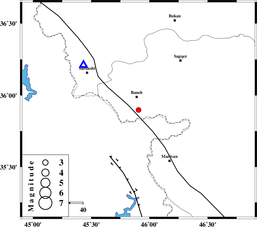
| Location | Lat:35.898 Lon: 45.906 |
| Region | Kurdistan Province, 10 km of Baneh |
Nearest Cities |
|
| 5 km of Buein-esofla, Kurdistan Province | |
| 10 km of Baneh, Kurdistan Province | |
| 10 km East of Armarde, Kurdistan Province | |
| 11 km North West of Nanur, Kurdistan Province | |
| 14 km North East of Balekeh, Kurdistan Province | |
| Depth | 14 km |
| Agency | |
Faults within 150 km: |
|
| PIRANSHAHR_F (Length: 253 km) , Distance to epicenter: 9 km | |
| HZF4 (Length: 492 km) , Distance to epicenter: 42 km | |
| SARTAKHT_F (Length: 78 km) , Distance to epicenter: 125 km | |
| Number of Phases | 7 |
| RMS | 0.3 |
| Number of Stations | 5 |
| Error in Latitude | >3.2 km |
| Error in Longitude | 4.3 km |
| Error in Depth | 7.2 km |
Download waveform in seisan format
to download seisan software Click here
to access information about IIEES stations Click here
Amplitude | ||||||||
| UID | Agency | Station | Component | Amplitude | Period | Arrival Time | Proccessing Time | Signal Clip |
| 141307 | IIEES | SRSL | E | 809.3 | 0.27 | 2019-02-23 09:56:03 | 2019-02-23 11:47:00 | n |
| 141308 | IIEES | SRSL | N | 1012.1 | 0.32 | 2019-02-23 09:56:03 | 2019-02-23 11:47:00 | n |
| 141309 | IIEES | ILBA | N | 36.4 | 0.34 | 2019-02-23 09:57:01 | 2019-02-23 11:47:00 | n |
| 141310 | IIEES | ILBA | E | 49 | 0.63 | 2019-02-23 09:57:05 | 2019-02-23 11:47:00 | n |
Phase | ||||||||||||
| Agency | Station | Component | Phase Type | Phase Quality | First Motion | Observed Arrival Time | Time Residual | Loc. Flag | Input Weight | Distance | Azimuth | |
| IIEES | SRSL | Z | EPg | E | 2019-02-23 09:55:52 | -0.11 | y | 55 | 309 | |||
| IIEES | SNGE | Z | EPg | E | 2019-02-23 09:56:08 | -0.41 | y | 158 | 124 | |||
| IIEES | SNGE | N | ESg | E | 2019-02-23 09:56:28 | -0.04 | y | 158 | 124 | |||
| IIEES | ILBA | Z | EPn | E | 2019-02-23 09:56:21 | 0.21 | y | 254 | 174 | |||
| IIEES | ILBA | N | ESg | E | 2019-02-23 09:56:53 | -0.14 | y | 254 | 174 | |||
| IIEES | ZNJK | Z | EPn | E | 2019-02-23 09:56:23 | -0.1 | y | 264 | 70 | |||
| IIEES | KHMZ | Z | EPn | E | 2019-02-23 09:56:46 | 0.81 | y | 442 | 122 | |||
کلیه حقوق مادی و معنوی این سایت متعلق به پژوهشگاه بین المللی زلزله شناسی و مهندسی زلزله می باشد.
