خانه / مشخصات زلزله
Magnitude |
:2.7 |
| Date & Time (UTC) | 2019-02-26 01:44:49.5 |
| Date & Time (Local) | 1397/12/7 05:14:49.5 |
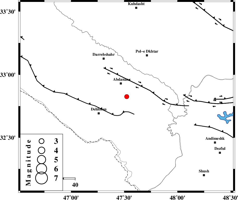
| Location | Lat:32.825 Lon: 47.523 |
| Region | Ilam Province, 13 km South of Abdanan |
Nearest Cities |
|
| 9 km of Sarabbagh, Ilam Province | |
| 13 km South of Abdanan, Ilam Province | |
| 29 km North East of Dehloran, Ilam Province | |
| 34 km South West of Sarab hammam, Lorestan Province | |
| 35 km North East of Musian, Ilam Province | |
| Depth | 15 km |
| Agency | |
Faults within 150 km: |
|
| MFF6 (Length: 144 km) , Distance to epicenter: 13 km | |
| BALARUD_F_Z1 (Length: 87 km) , Distance to epicenter: 21 km | |
| BALARUD_F_Z3 (Length: 53 km) , Distance to epicenter: 50 km | |
| Number of Phases | 6 |
| RMS | 0.1 |
| Number of Stations | 6 |
| Error in Latitude | >7.8 km |
| Error in Longitude | 1.7 km |
| Error in Depth | 0 km |
Download waveform in seisan format
to download seisan software Click here
to access information about IIEES stations Click here
Amplitude | ||||||||
| UID | Agency | Station | Component | Amplitude | Period | Arrival Time | Proccessing Time | Signal Clip |
| 141385 | IIEES | KHMZ | E | 26.6 | 0.68 | 2019-02-26 01:46:11 | 2019-02-26 10:37:00 | n |
| 141386 | IIEES | SNGE | E | 27.5 | 0.68 | 2019-02-26 01:46:03 | 2019-02-26 10:37:00 | n |
| 141387 | IIEES | SNGE | N | 27.7 | 0.49 | 2019-02-26 01:46:10 | 2019-02-26 10:37:00 | n |
| 141388 | IIEES | ASAO | N | 27.4 | 0.79 | 2019-02-26 01:46:24 | 2019-02-26 10:37:00 | n |
| 141389 | IIEES | ASAO | E | 22.3 | 0.44 | 2019-02-26 01:46:27 | 2019-02-26 10:37:00 | n |
| 141390 | IIEES | GHVR | N | 11.2 | 0.58 | 2019-02-26 01:46:37 | 2019-02-26 10:37:00 | n |
| 141391 | IIEES | GHVR | E | 18 | 0.58 | 2019-02-26 01:46:38 | 2019-02-26 10:37:00 | n |
Phase | ||||||||||||
| Agency | Station | Component | Phase Type | Phase Quality | First Motion | Observed Arrival Time | Time Residual | Loc. Flag | Input Weight | Distance | Azimuth | |
| IIEES | KHMZ | Z | EPn | E | 2019-02-26 01:45:28 | 0.01 | y | 249 | 65 | |||
| IIEES | SNGE | Z | EPn | E | 2019-02-26 01:45:28 | 0.09 | y | 252 | 356 | |||
| IIEES | ASAO | Z | EPn | E | 2019-02-26 01:45:34 | -0.01 | y | 301 | 50 | |||
| IIEES | GHVR | Z | EPn | E | 2019-02-26 01:45:45 | 0.13 | y | 391 | 61 | |||
| IIEES | ZNJK | Z | EPn | E | 2019-02-26 01:45:51 | -0.2 | y | 440 | 14 | |||
| IIEES | NASN | Z | EPn | E | 2019-02-26 01:45:58 | -0.08 | y | 495 | 89 | |||
کلیه حقوق مادی و معنوی این سایت متعلق به پژوهشگاه بین المللی زلزله شناسی و مهندسی زلزله می باشد.
