خانه / مشخصات زلزله
Magnitude |
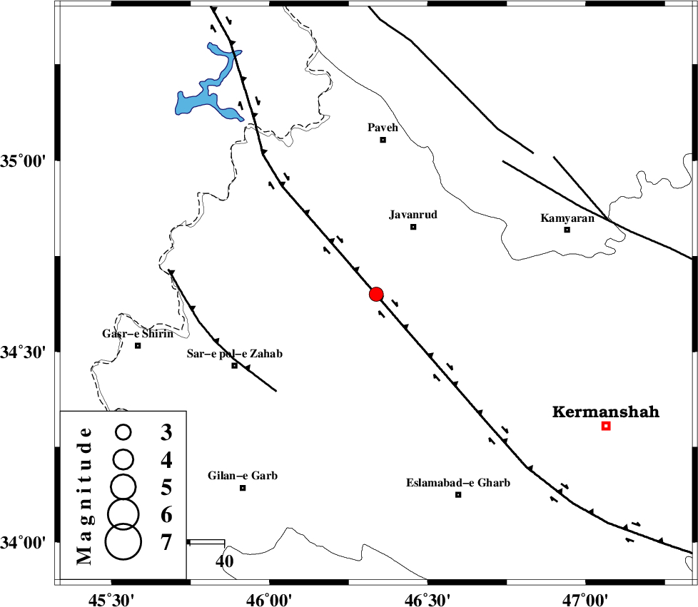
:2.8 |
| Date & Time (UTC) | 2019-03-09 00:07:49.9 |
| Date & Time (Local) | 1397/12/18 03:37:49.9 |
| Location | Lat:34.651 Lon: 46.337 |
| Region | Kermanshah Province, 22 km South-West of Javanrud |
Nearest Cities |
|
| 5 km of Mirabad, Kermanshah Province | |
| 13 km West of Dolatabad, Kermanshah Province | |
| 16 km South West of Sarukhan, Kermanshah Province | |
| 17 km North of Zavleh olia, Kermanshah Province | |
| 18 km East of Qolqoleh, Kermanshah Province | |
| Depth | 14 km |
| Agency | |
Faults within 150 km: |
|
| HZF4 (Length: 492 km) , Distance to epicenter: 10 km | |
| MFF8 (Length: 48 km) , Distance to epicenter: 40 km | |
| SARTAKHT_F (Length: 78 km) , Distance to epicenter: 53 km | |
| Number of Phases | 6 |
| RMS | 0.3 |
| Number of Stations | 4 |
| Error in Latitude | >2.3 km |
| Error in Longitude | 2.8 km |
| Error in Depth | 8.8 km |
Download waveform in seisan format
to download seisan software Click here
to access information about IIEES stations Click here
Amplitude | ||||||||
| UID | Agency | Station | Component | Amplitude | Period | Arrival Time | Proccessing Time | Signal Clip |
| 141508 | IIEES | ILBA | E | 239.5 | 0.46 | 2019-03-09 00:08:24 | 2019-03-09 08:25:00 | n |
| 141509 | IIEES | ILBA | N | 240.1 | 0.23 | 2019-03-09 00:08:24 | 2019-03-09 08:25:00 | n |
| 141510 | IIEES | SRSL | N | 103.1 | 0.49 | 2019-03-09 00:08:49 | 2019-03-09 08:25:00 | n |
| 141511 | IIEES | SRSL | E | 90.1 | 0.45 | 2019-03-09 00:08:51 | 2019-03-09 08:25:00 | n |
Phase | ||||||||||||
| Agency | Station | Component | Phase Type | Phase Quality | First Motion | Observed Arrival Time | Time Residual | Loc. Flag | Input Weight | Distance | Azimuth | |
| IIEES | SNGE | Z | EPg | E | 2019-03-09 00:08:07 | -0.35 | y | 105 | 62 | |||
| IIEES | SNGE | N | ESg | E | 2019-03-09 00:08:20 | 0.09 | y | 105 | 62 | |||
| IIEES | ILBA | Z | EPg | E | 2019-03-09 00:08:09 | -0.02 | y | 114 | 186 | |||
| IIEES | SRSL | Z | EPg | E | 2019-03-09 00:08:21 | -0.28 | y | 192 | 335 | |||
| IIEES | SRSL | N | ESg | E | 2019-03-09 00:08:44 | 0.25 | y | 192 | 335 | |||
| IIEES | KHMZ | Z | EPn | E | 2019-03-09 00:08:41 | 0.36 | y | 349 | 106 | |||
کلیه حقوق مادی و معنوی این سایت متعلق به پژوهشگاه بین المللی زلزله شناسی و مهندسی زلزله می باشد.
