خانه / مشخصات زلزله
Magnitude |
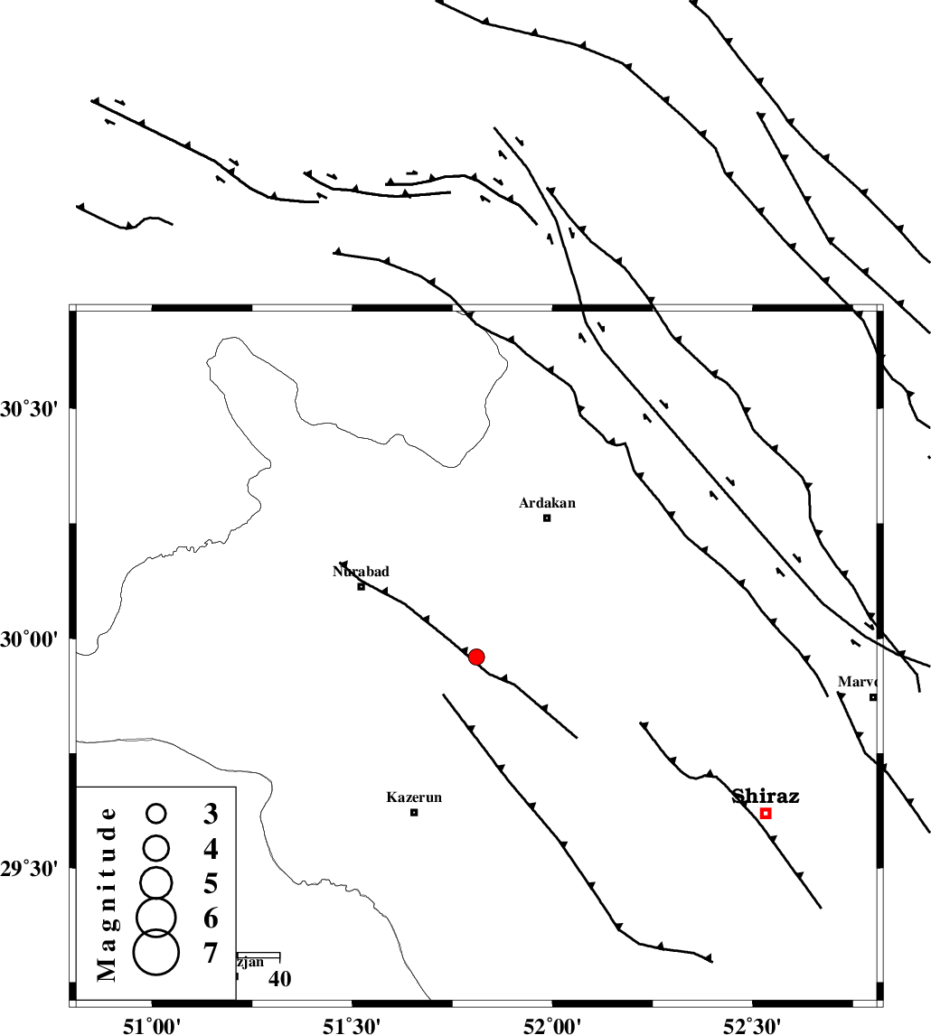
:2.6 |
| Date & Time (UTC) | 2019-10-02 08:35:12.9 |
| Date & Time (Local) | 1398/7/10 12:05:12.9 |
| Location | Lat:29.96 Lon: 51.81 |
| Region | Fars Province, 33 km South-East of Nurabad |
Nearest Cities |
|
| 21 km North East of Nodan, Fars Province | |
| 25 km North East of Seyyed hasan, Fars Province | |
| 30 km South East of Gachgaran, Fars Province | |
| 33 km South East of Nurabad, Fars Province | |
| 35 km South West of Bahrghan, Fars Province | |
| Depth | 5 km |
| Agency | |
Faults within 150 km: |
|
| KAZERUN_F (Length: 96 km) , Distance to epicenter: 21 km | |
| KAREBASS_F (Length: 98 km) , Distance to epicenter: 27 km | |
| HZF3 (Length: 197 km) , Distance to epicenter: 40 km | |
| Number of Phases | 6 |
| RMS | 0.2 |
| Number of Stations | 4 |
| Error in Latitude | >0 km |
| Error in Longitude | 0 km |
| Error in Depth | 0 km |
Download waveform in seisan format
to download seisan software Click here
to access information about IIEES stations Click here
Amplitude | ||||||||
| UID | Agency | Station | Component | Amplitude | Period | Arrival Time | Proccessing Time | Signal Clip |
| 146085 | IIEES SC | KLNJ | Z | 140 | 1 | 2019-10-02 08:35:54 | 2019-10-02 02:23:00 | n |
| 146086 | IIEES SC | AHRM | Z | 37 | 1 | 2019-10-02 08:35:38 | 2019-10-02 02:23:00 | n |
| 146087 | IIEES SC | GHIR | Z | 15 | 1 | 2019-10-02 08:36:23 | 2019-10-02 02:23:00 | n |
Phase | ||||||||||||
| Agency | Station | Component | Phase Type | Phase Quality | First Motion | Observed Arrival Time | Time Residual | Loc. Flag | Input Weight | Distance | Azimuth | |
| IIEES SC | KLNJ | N | IS | I | 2019-10-02 08:35:49 | 0.3 | y | 122 | 350 | |||
| IIEES SC | KLNJ | Z | IP | I | 2019-10-02 08:35:33 | -0.5 | y | 122 | 350 | |||
| IIEES SC | AHRM | Z | IP | I | 2019-10-02 08:35:35 | 0 | y | 133 | 202 | |||
| IIEES SC | GHIR | Z | IP | I | 2019-10-02 08:35:48 | 0 | y | 222 | 148 | |||
| IIEES SC | AHRM | 836 | 2019-10-02 08:36:05 | y | 133 | 202 | ||||||
| IIEES SC | GHIR | 836 | 2019-10-02 08:36:47 | y | 222 | 148 | ||||||
کلیه حقوق مادی و معنوی این سایت متعلق به پژوهشگاه بین المللی زلزله شناسی و مهندسی زلزله می باشد.
