خانه / مشخصات زلزله
Magnitude |
:2.8 |
| Date & Time (UTC) | 2019-10-05 04:15:58.9 |
| Date & Time (Local) | 1398/7/13 07:45:58.9 |
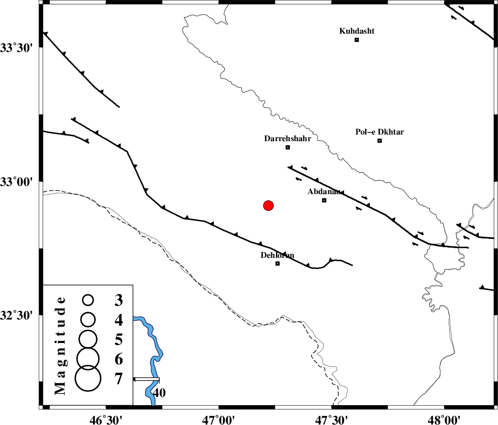
| Location | Lat:32.91 Lon: 47.22 |
| Region | Ilam Province, 24 km North of Dehloran |
Nearest Cities |
|
| 23 km West of Abdanan, Ilam Province | |
| 24 km North of Dehloran, Ilam Province | |
| 25 km North East of Bishehzar, Ilam Province | |
| 25 km South of Darreh Shahr, Ilam Province | |
| 30 km South West of Dashtabad-e olia, Ilam Province | |
| Depth | 14 km |
| Agency | |
Faults within 150 km: |
|
| MFF6 (Length: 144 km) , Distance to epicenter: 17 km | |
| BALARUD_F_Z1 (Length: 87 km) , Distance to epicenter: 18 km | |
| MFF7 (Length: 99 km) , Distance to epicenter: 74 km | |
| Number of Phases | 6 |
| RMS | 0.2 |
| Number of Stations | 6 |
| Error in Latitude | >8 km |
| Error in Longitude | 0 km |
| Error in Depth | 19 km |
Download waveform in seisan format
to download seisan software Click here
to access information about IIEES stations Click here
Amplitude | ||||||||
| UID | Agency | Station | Component | Amplitude | Period | Arrival Time | Proccessing Time | Signal Clip |
| 146249 | IIEES SC | GTMR | Z | 150 | 1 | 2019-10-05 04:16:56 | 2019-10-05 02:31:00 | n |
| 146250 | IIEES SC | KGS1 | Z | 89 | 1 | 2019-10-05 04:17:29 | 2019-10-05 02:31:00 | n |
| 146251 | IIEES SC | KHMZ | Z | 31 | 1 | 2019-10-05 04:17:28 | 2019-10-05 02:31:00 | n |
| 146252 | IIEES SC | ASAO | Z | 21 | 1 | 2019-10-05 04:17:44 | 2019-10-05 02:31:00 | n |
| 146253 | IIEES SC | QABG | Z | 2.8 | 1 | 2019-10-05 04:17:22 | 2019-10-05 02:31:00 | n |
Phase | ||||||||||||
| Agency | Station | Component | Phase Type | Phase Quality | First Motion | Observed Arrival Time | Time Residual | Loc. Flag | Input Weight | Distance | Azimuth | |
| IIEES SC | GTMR | Z | IP | I | 2019-10-05 04:16:28 | 0 | y | 189 | 105 | |||
| IIEES SC | KGS1 | Z | IP | I | 2019-10-05 04:16:35 | -0.1 | y | 233 | 320 | |||
| IIEES SC | KHMZ | Z | IP | I | 2019-10-05 04:16:40 | 0 | y | 266 | 70 | |||
| IIEES SC | ASAO | Z | IP | I | 2019-10-05 04:16:46 | 0.3 | y | 322 | 55 | |||
| IIEES SC | QABG | Z | IP | I | 2019-10-05 04:16:53 | -0.7 | y | 378 | 35 | |||
| IIEES SC | SRSL | Z | IP | I | 2019-10-05 04:16:56 | 0.1 | y | 400 | 336 | |||
کلیه حقوق مادی و معنوی این سایت متعلق به پژوهشگاه بین المللی زلزله شناسی و مهندسی زلزله می باشد.
