خانه / مشخصات زلزله
Magnitude |
:2.9 |
| Date & Time (UTC) | 2019-10-13 01:26:27.0 |
| Date & Time (Local) | 1398/7/21 04:56:27.0 |
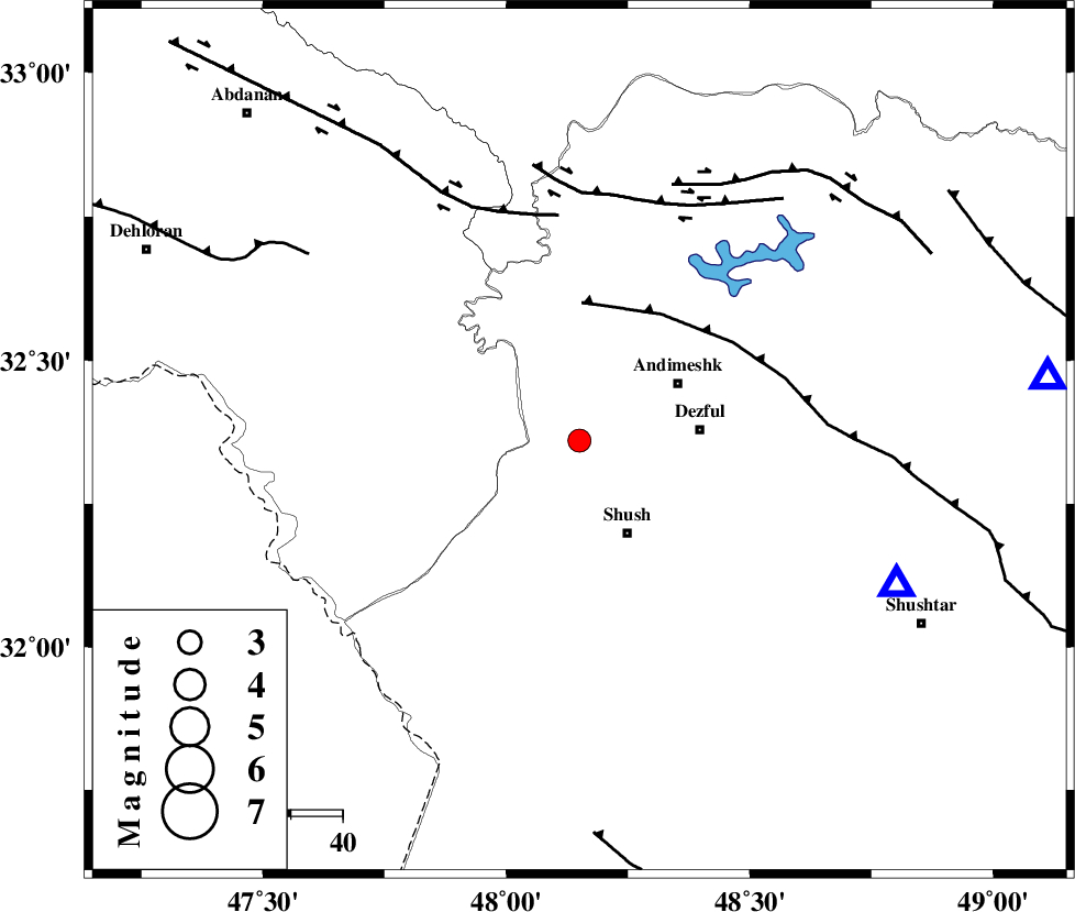
| Location | Lat:32.36 Lon: 48.15 |
| Region | Khoozestan Province, 20 km North of Shush |
Nearest Cities |
|
| 20 km North of Shush, Khoozestan Province | |
| 22 km West of Andimeshk, Khoozestan Province | |
| 23 km West of Dezful, Khoozestan Province | |
| 23 km North West of Amaleh teimur, Khoozestan Province | |
| 27 km North West of Shamsabad, Khoozestan Province | |
| Depth | 14 km |
| Agency | |
Faults within 150 km: |
|
| DEZFUL_EMBAYMENT (Length: 228 km) , Distance to epicenter: 27 km | |
| BALARUD_F_Z1 (Length: 87 km) , Distance to epicenter: 44 km | |
| BALARUD_F_Z3 (Length: 53 km) , Distance to epicenter: 48 km | |
| Number of Phases | 6 |
| RMS | 0.4 |
| Number of Stations | 6 |
| Error in Latitude | >5 km |
| Error in Longitude | 0 km |
| Error in Depth | 691 km |
Download waveform in seisan format
to download seisan software Click here
to access information about IIEES stations Click here
Amplitude | ||||||||
| UID | Agency | Station | Component | Amplitude | Period | Arrival Time | Proccessing Time | Signal Clip |
| 146542 | IIEES SC | KHMZ | Z | 68 | 1 | 2019-10-13 01:27:43 | 2019-10-13 08:40:00 | n |
| 146543 | IIEES SC | ASAO | Z | 44 | 1 | 2019-10-13 01:28:03 | 2019-10-13 08:40:00 | n |
| 146544 | IIEES SC | KGS1 | Z | 63 | 1 | 2019-10-13 01:28:05 | 2019-10-13 08:40:00 | n |
| 146545 | IIEES SC | KLNJ | Z | 21 | 1 | 2019-10-13 01:28:29 | 2019-10-13 08:40:00 | n |
| 146546 | IIEES SC | GHVR | Z | 41 | 1 | 2019-10-13 01:28:34 | 2019-10-13 08:40:00 | n |
| 146547 | IIEES SC | QABG | Z | 5.5 | 1 | 2019-10-13 01:27:25 | 2019-10-13 08:40:00 | n |
Phase | ||||||||||||
| Agency | Station | Component | Phase Type | Phase Quality | First Motion | Observed Arrival Time | Time Residual | Loc. Flag | Input Weight | Distance | Azimuth | |
| IIEES SC | KHMZ | Z | IP | I | 2019-10-13 01:27:03 | 0 | y | 233 | 48 | |||
| IIEES SC | ASAO | Z | IP | I | 2019-10-13 01:27:12 | 0.7 | y | 300 | 36 | |||
| IIEES SC | KGS1 | Z | IP | I | 2019-10-13 01:27:16 | -0.1 | y | 333 | 315 | |||
| IIEES SC | KLNJ | Z | IP | I | 2019-10-13 01:27:19 | 0.1 | y | 355 | 115 | |||
| IIEES SC | GHVR | N | IP | I | 2019-10-13 01:27:19 | -1.1 | y | 366 | 51 | |||
| IIEES SC | QABG | Z | IP | I | 2019-10-13 01:27:24 | 0 | y | 400 | 20 | |||
کلیه حقوق مادی و معنوی این سایت متعلق به پژوهشگاه بین المللی زلزله شناسی و مهندسی زلزله می باشد.
