خانه / مشخصات زلزله
Magnitude |
:2.7 |
| Date & Time (UTC) | 2019-10-13 05:58:50.8 |
| Date & Time (Local) | 1398/7/21 09:28:50.8 |
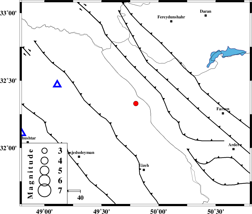
| Location | Lat:32.33 Lon: 49.8 |
| Region | Khoozestan Province, 34 km South-West of Chelgard |
Nearest Cities |
|
| 23 km North East of Paabshalal, Khoozestan Province | |
| 34 km South West of Chelgard, Chaharmahal Bakhtiari Province | |
| 36 km North East of Qale-yekhvaju, Khoozestan Province | |
| 37 km North of Torshak, Khoozestan Province | |
| 41 km South of Durak, Chaharmahal Bakhtiari Province | |
| Depth | 14 km |
| Agency | |
Faults within 150 km: |
|
| ZARDKUH_F (Length: 139 km) , Distance to epicenter: 22 km | |
| MFF2 (Length: 205 km) , Distance to epicenter: 27 km | |
| ARDAL_F (Length: 170 km) , Distance to epicenter: 33 km | |
| Number of Phases | 5 |
| RMS | 0.3 |
| Number of Stations | 5 |
| Error in Latitude | >4 km |
| Error in Longitude | 0 km |
| Error in Depth | 17 km |
Download waveform in seisan format
to download seisan software Click here
to access information about IIEES stations Click here
Amplitude | ||||||||
| UID | Agency | Station | Component | Amplitude | Period | Arrival Time | Proccessing Time | Signal Clip |
| 146577 | IIEES SC | KHMZ | Z | 150 | 1 | 2019-10-13 05:59:42 | 2019-10-14 08:46:00 | n |
| 146578 | IIEES SC | KLNJ | Z | 96 | 1 | 2019-10-13 06:00:02 | 2019-10-14 08:46:00 | n |
| 146579 | IIEES SC | ASAO | Z | 93 | 1 | 2019-10-13 06:00:08 | 2019-10-14 08:46:00 | n |
| 146580 | IIEES SC | GHVR | Z | 64 | 1 | 2019-10-13 06:00:18 | 2019-10-14 08:46:00 | n |
| 146581 | IIEES SC | QABG | Z | 5.5 | 1 | 2019-10-13 06:00:42 | 2019-10-14 08:46:00 | n |
Phase | ||||||||||||
| Agency | Station | Component | Phase Type | Phase Quality | First Motion | Observed Arrival Time | Time Residual | Loc. Flag | Input Weight | Distance | Azimuth | |
| IIEES SC | KHMZ | Z | IP | I | 2019-10-13 05:59:16 | -0.2 | y | 155 | 6 | |||
| IIEES SC | KLNJ | Z | IP | I | 2019-10-13 05:59:26 | 0 | y | 222 | 131 | |||
| IIEES SC | ASAO | Z | IP | I | 2019-10-13 05:59:30 | 0.8 | y | 244 | 5 | |||
| IIEES SC | GHVR | N | IP | I | 2019-10-13 05:59:32 | 0.1 | y | 278 | 29 | |||
| IIEES SC | QABG | Z | IP | I | 2019-10-13 05:59:44 | -0.6 | y | 378 | 357 | |||
کلیه حقوق مادی و معنوی این سایت متعلق به پژوهشگاه بین المللی زلزله شناسی و مهندسی زلزله می باشد.
