خانه / مشخصات زلزله
Magnitude |
:3 |
| Date & Time (UTC) | 2019-11-17 22:21:00.3 |
| Date & Time (Local) | 1398/8/27 01:51:00.3 |
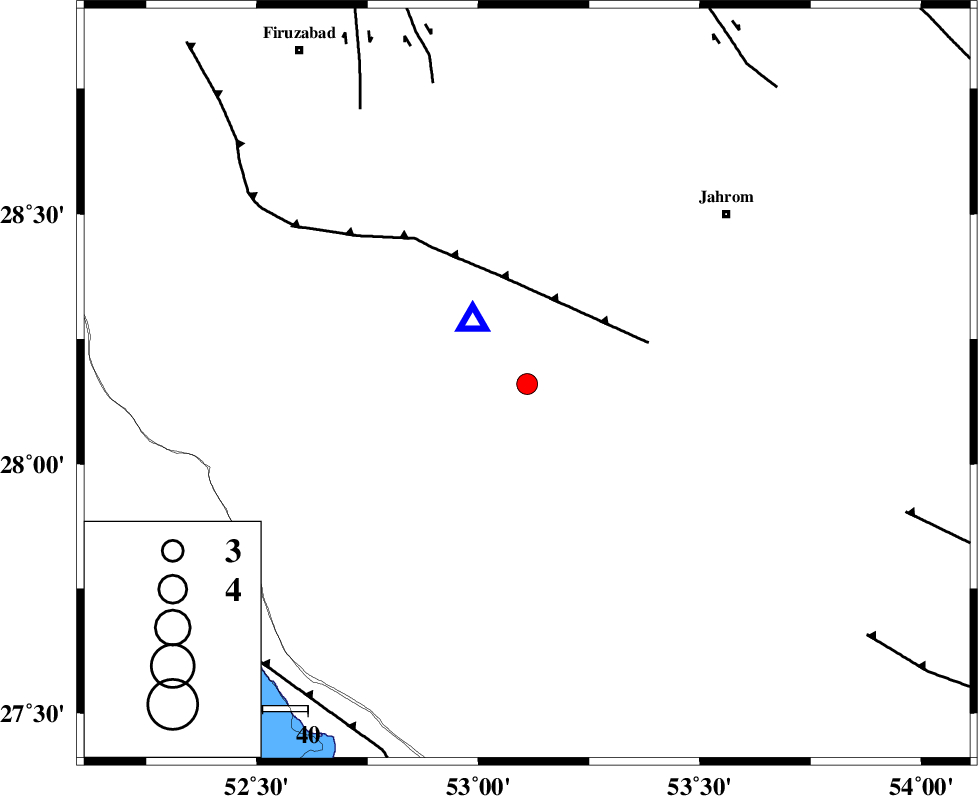
| Location | Lat:28.16 Lon: 53.11 |
| Region | Fars Province, 35 km South of Qir va Karzin |
Nearest Cities |
|
| 3 km of Seyfabad, Fars Province | |
| 28 km South of Shahrak-e jonubi, Fars Province | |
| 31 km South West of Mobarakabad, Fars Province | |
| 35 km South of Qir va Karzin, Fars Province | |
| 36 km South of Fathabad, Fars Province | |
| Depth | 10 km |
| Agency | |
Faults within 150 km: |
|
| QIR_F (Length: 130 km) , Distance to epicenter: 25 km | |
| SABZ_PUSHAN_F_Z2 (Length: 24 km) , Distance to epicenter: 70 km | |
| SABZ_PUSHAN_F_Z1 (Length: 69 km) , Distance to epicenter: 71 km | |
| Number of Phases | 6 |
| RMS | 0.3 |
| Number of Stations | 6 |
| Error in Latitude | >3 km |
| Error in Longitude | 0 km |
| Error in Depth | 4 km |
Download waveform in seisan format
to download seisan software Click here
to access information about IIEES stations Click here
Amplitude | ||||||||
| UID | Agency | Station | Component | Amplitude | Period | Arrival Time | Proccessing Time | Signal Clip |
| 148473 | IIEES SC | GHIR | Z | 580 | 1 | 2019-11-17 22:21:16 | 2019-11-18 08:29:00 | n |
| 148474 | IIEES SC | LMD1 | Z | 670 | 1 | 2019-11-17 22:21:32 | 2019-11-18 08:29:00 | n |
| 148475 | IIEES SC | KLNJ | Z | 26 | 1 | 2019-11-17 22:22:54 | 2019-11-18 08:29:00 | n |
| 148476 | IIEES SC | KRBR | Z | 25 | 1 | 2019-11-17 22:23:11 | 2019-11-18 08:29:00 | n |
| 148477 | IIEES SC | YZKH | Z | 5 | 1 | 2019-11-17 22:22:55 | 2019-11-18 08:29:00 | n |
| 148478 | IIEES SC | NASN | Z | 4.8 | 1 | 2019-11-17 22:23:11 | 2019-11-18 08:29:00 | n |
Phase | ||||||||||||
| Agency | Station | Component | Phase Type | Phase Quality | First Motion | Observed Arrival Time | Time Residual | Loc. Flag | Input Weight | Distance | Azimuth | |
| IIEES SC | GHIR | Z | IP | I | 2019-11-17 22:21:04 | -0.1 | y | 22 | 321 | |||
| IIEES SC | LMD1 | N | IP | I | 2019-11-17 22:21:16 | 0 | y | 88 | 176 | |||
| IIEES SC | KLNJ | Z | IP | I | 2019-11-17 22:21:52 | 0.7 | y | 344 | 335 | |||
| IIEES SC | KRBR | N | IP | I | 2019-11-17 22:21:59 | 0 | y | 411 | 60 | |||
| IIEES SC | YZKH | Z | IP | I | 2019-11-17 22:22:09 | -0.3 | y | 489 | 17 | |||
| IIEES SC | NASN | Z | IP | I | 2019-11-17 22:22:12 | -0.4 | y | 511 | 357 | |||
کلیه حقوق مادی و معنوی این سایت متعلق به پژوهشگاه بین المللی زلزله شناسی و مهندسی زلزله می باشد.
