خانه / مشخصات زلزله
Magnitude |
:3.2 |
| Date & Time (UTC) | 2019-11-29 22:50:27.6 |
| Date & Time (Local) | 1398/9/9 02:20:27.6 |
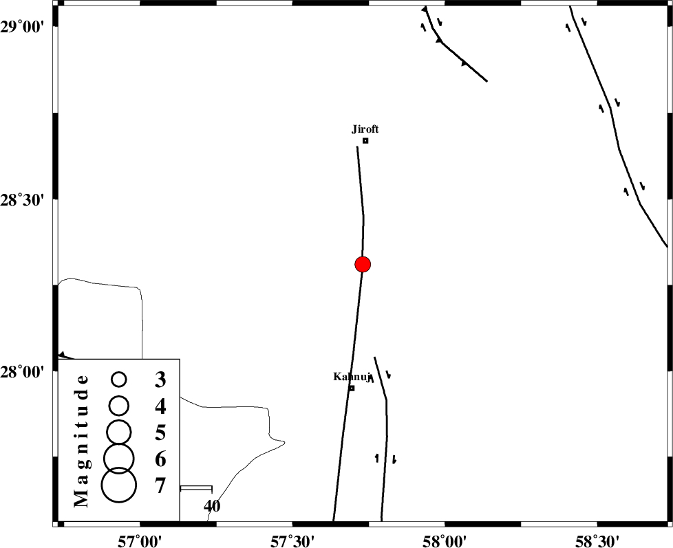
| Location | Lat:28.31 Lon: 57.73 |
| Region | Kerman Province, 40 km South of Jiroft |
Nearest Cities |
|
| 20 km South West of Aliabad-e qadiri, Kerman Province | |
| 21 km North East of Bolock, Kerman Province | |
| 23 km South West of Khesrabad, Kerman Province | |
| 25 km South West of Dosari, Kerman Province | |
| 30 km South of Khatunabad-e zangian, Kerman Province | |
| Depth | 46 km |
| Agency | |
Faults within 150 km: |
|
| SABZEVARAN_F (Length: 190 km) , Distance to epicenter: 3 km | |
| JIROFT_F (Length: 144 km) , Distance to epicenter: 30 km | |
| GOWK_F (Length: 152 km) , Distance to epicenter: 71 km | |
| Number of Phases | 6 |
| RMS | 0.2 |
| Number of Stations | 6 |
| Error in Latitude | >8 km |
| Error in Longitude | 0 km |
| Error in Depth | 11 km |
Download waveform in seisan format
to download seisan software Click here
to access information about IIEES stations Click here
Amplitude | ||||||||
| UID | Agency | Station | Component | Amplitude | Period | Arrival Time | Proccessing Time | Signal Clip |
| 149140 | IIEES SC | BNDS | Z | 91 | 1 | 2019-11-29 22:51:52 | 2019-12-01 11:28:00 | n |
| 149141 | IIEES SC | KRBR | Z | 170 | 1 | 2019-11-29 22:51:29 | 2019-12-01 11:28:00 | n |
| 149142 | IIEES SC | YZKH | Z | 8.1 | 1 | 2019-11-29 22:53:20 | 2019-12-01 11:28:00 | n |
| 149143 | IIEES SC | TABS | Z | 6.5 | 1 | 2019-11-29 22:53:36 | 2019-12-01 11:28:00 | n |
| 149144 | IIEES SC | TABS | Z | 6 | 1.22 | 2019-11-29 22:52:12 | 2019-12-01 11:28:00 | n |
Phase | ||||||||||||
| Agency | Station | Component | Phase Type | Phase Quality | First Motion | Observed Arrival Time | Time Residual | Loc. Flag | Input Weight | Distance | Azimuth | |
| IIEES SC | BNDS | N | IS | I | 2019-11-29 22:51:16 | 0.1 | y | 177 | 237 | |||
| IIEES SC | BNDS | Z | IP | I | 2019-11-29 22:50:55 | -0.1 | y | 177 | 237 | |||
| IIEES SC | KRBR | N | IS | I | 2019-11-29 22:51:21 | -0.2 | y | 211 | 333 | |||
| IIEES SC | KRBR | Z | IP | I | 2019-11-29 22:50:58 | 0 | y | 211 | 333 | |||
| IIEES SC | YZKH | Z | IP | I | 2019-11-29 22:51:40 | 0.4 | y | 544 | 326 | |||
| IIEES SC | TABS | Z | IP | I | 2019-11-29 22:51:46 | 0.3 | y | 600 | 354 | |||
کلیه حقوق مادی و معنوی این سایت متعلق به پژوهشگاه بین المللی زلزله شناسی و مهندسی زلزله می باشد.
