خانه / مشخصات زلزله
Magnitude |
:2.5 |
| Date & Time (UTC) | 2019-12-10 08:52:28.5 |
| Date & Time (Local) | 1398/9/19 12:22:28.5 |
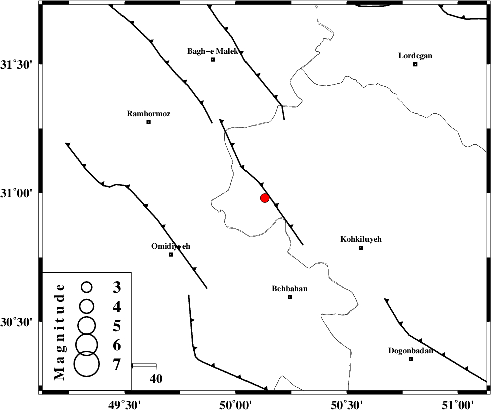
| Location | Lat:30.98 Lon: 50.13 |
| Region | Kohkiluieh va boyerahmad Province, 44 km North-West of Behbahan |
Nearest Cities |
|
| 28 km North West of Lendeh, Kohkiluieh va boyerahmad Province | |
| 28 km North East of Jolaki, Khoozestan Province | |
| 29 km North East of Jayzan, Khoozestan Province | |
| 30 km North of Dodange-ye bozorg, Khoozestan Province | |
| 37 km South West of Esfandan, Kohkiluieh va boyerahmad Province | |
| Depth | 14 km |
| Agency | |
Faults within 150 km: |
|
| MFF4 (Length: 62 km) , Distance to epicenter: 2 km | |
| MFF2 (Length: 205 km) , Distance to epicenter: 35 km | |
| DEZFUL_EMBAYMENT (Length: 228 km) , Distance to epicenter: 39 km | |
| Number of Phases | 5 |
| RMS | 0.3 |
| Number of Stations | 5 |
| Error in Latitude | >7 km |
| Error in Longitude | 0 km |
| Error in Depth | 13 km |
Download waveform in seisan format
to download seisan software Click here
to access information about IIEES stations Click here
Amplitude | ||||||||
| UID | Agency | Station | Component | Amplitude | Period | Arrival Time | Proccessing Time | Signal Clip |
| 149616 | IIEES SC | KLNJ | Z | 130 | 1 | 2019-12-10 08:53:15 | 2019-12-11 02:51:00 | n |
| 149617 | IIEES SC | GTMR | Z | 53 | 1 | 2019-12-10 08:53:29 | 2019-12-11 02:51:00 | n |
| 149618 | IIEES SC | NASN | Z | 5.2 | 1 | 2019-12-10 08:54:00 | 2019-12-11 02:51:00 | n |
Phase | ||||||||||||
| Agency | Station | Component | Phase Type | Phase Quality | First Motion | Observed Arrival Time | Time Residual | Loc. Flag | Input Weight | Distance | Azimuth | |
| IIEES SC | KLNJ | N | IS | I | 2019-12-10 08:53:09 | 0.4 | y | 144 | 89 | |||
| IIEES SC | KLNJ | Z | IP | I | 2019-12-10 08:52:51 | -0.2 | y | 144 | 89 | |||
| IIEES SC | GTMR | N | IS | I | 2019-12-10 08:53:22 | 0 | y | 189 | 330 | |||
| IIEES SC | GTMR | Z | IP | I | 2019-12-10 08:52:59 | 0.2 | y | 189 | 330 | |||
| IIEES SC | NASN | Z | IP | I | 2019-12-10 08:53:16 | -0.7 | y | 322 | 51 | |||
کلیه حقوق مادی و معنوی این سایت متعلق به پژوهشگاه بین المللی زلزله شناسی و مهندسی زلزله می باشد.
