خانه / مشخصات زلزله
Magnitude |
:3 |
| Date & Time (UTC) | 2020-04-20 06:17:04.2 |
| Date & Time (Local) | 1399/2/1 10:47:04.2 |
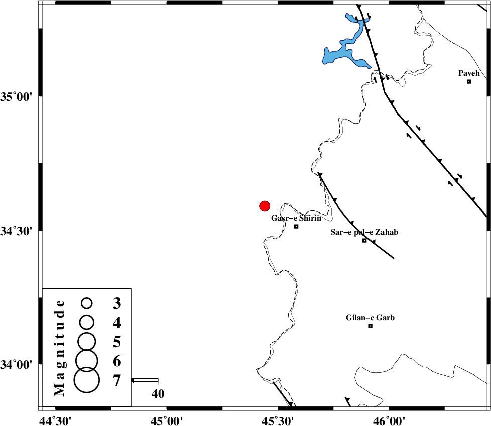
| Location | Lat:34.59 Lon: 45.44 |
| Region | Iraq, 15 km -West of Qasr-E-Shirin |
Nearest Cities |
|
| 15 km North West of Qasr-E-Shirin, Kermanshah Province | |
| 21 km North of Khosravi, Kermanshah Province | |
| 21 km North West of Aqabarar, Kermanshah Province | |
| 22 km North West of Seyyed sohrab, Kermanshah Province | |
| 30 km North West of Mirmiru, Kermanshah Province | |
| Depth | 10 km |
| Agency | |
Faults within 150 km: |
|
| MFF8 (Length: 48 km) , Distance to epicenter: 26 km | |
| HZF4 (Length: 492 km) , Distance to epicenter: 67 km | |
| ZFF4 (Length: 128 km) , Distance to epicenter: 73 km | |
| Number of Phases | 6 |
| RMS | 1 |
| Number of Stations | 6 |
| Error in Latitude | >2 km |
| Error in Longitude | 0 km |
| Error in Depth | 21 km |
Download waveform in seisan format
to download seisan software Click here
to access information about IIEES stations Click here
Amplitude | ||||||||
| UID | Agency | Station | Component | Amplitude | Period | Arrival Time | Proccessing Time | Signal Clip |
| 153125 | IIEES SC | SRSL | Z | 69 | 1 | 2020-04-20 06:17:58 | 2020-04-20 11:50:00 | n |
| 153126 | IIEES SC | SNGE | Z | 190 | 1 | 2020-04-20 06:17:58 | 2020-04-20 11:50:00 | n |
| 153127 | IIEES SC | MAHB | Z | 55 | 1 | 2020-04-20 06:18:17 | 2020-04-20 11:50:00 | n |
| 153128 | IIEES SC | AZR | Z | 110 | 1 | 2020-04-20 06:18:59 | 2020-04-20 11:50:00 | n |
| 153129 | IIEES SC | QABG | Z | 1.7 | 1 | 2020-04-20 06:19:02 | 2020-04-20 11:50:00 | n |
Phase | ||||||||||||
| Agency | Station | Component | Phase Type | Phase Quality | First Motion | Observed Arrival Time | Time Residual | Loc. Flag | Input Weight | Distance | Azimuth | |
| IIEES SC | SRSL | N | IS | I | 2020-04-20 06:17:56 | 0.8 | y | 177 | 360 | |||
| IIEES SC | SRSL | Z | IP | I | 2020-04-20 06:17:32 | -0.9 | y | 177 | 360 | |||
| IIEES SC | SNGE | Z | IP | I | 2020-04-20 06:17:33 | -0.7 | y | 177 | 72 | |||
| IIEES SC | MAHB | Z | IP | I | 2020-04-20 06:17:41 | -1.2 | y | 244 | 6 | |||
| IIEES SC | AZR | Z | IP | I | 2020-04-20 06:17:56 | 1 | y | 344 | 8 | |||
| IIEES SC | QABG | Z | IP | I | 2020-04-20 06:18:03 | 1.1 | y | 400 | 72 | |||
کلیه حقوق مادی و معنوی این سایت متعلق به پژوهشگاه بین المللی زلزله شناسی و مهندسی زلزله می باشد.
