خانه / مشخصات زلزله
Magnitude |
:3.1 |
| Date & Time (UTC) | 2020-07-04 09:01:56.5 |
| Date & Time (Local) | 1399/4/14 13:31:56.5 |
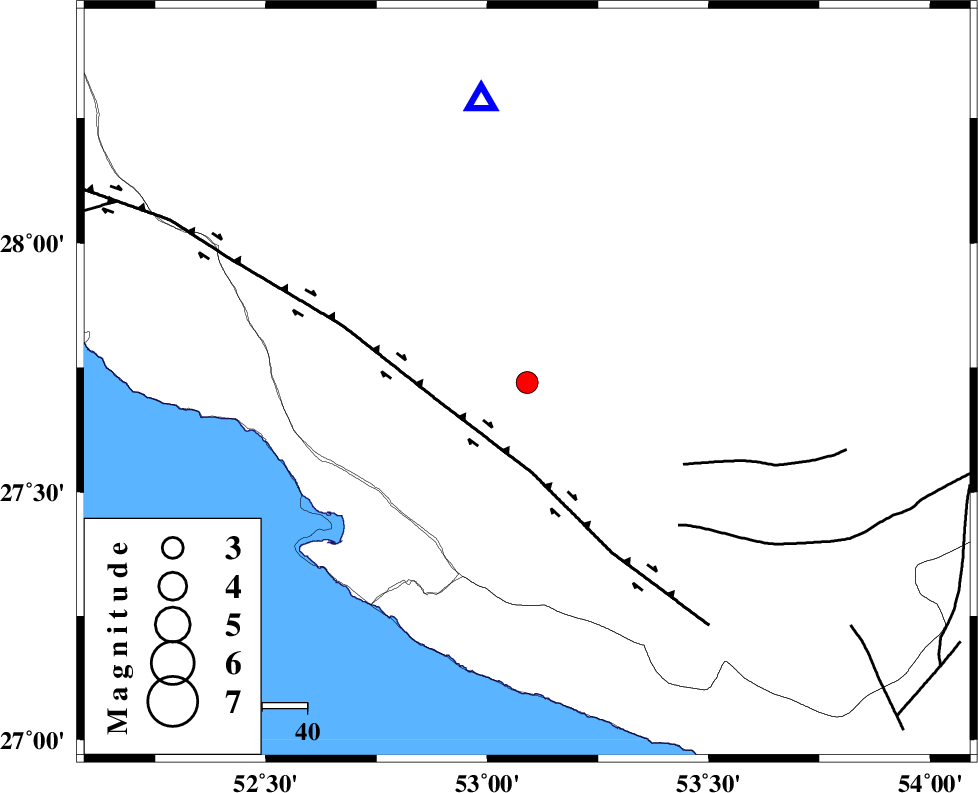
| Location | Lat:27.72 Lon: 53.09 |
| Region | Fars Province, 28 km North-East of Mehr |
Nearest Cities |
|
| 17 km North East of Alamarvdasht, Fars Province | |
| 28 km North East of Mehr, Fars Province | |
| 32 km North East of Ardavan-e olia, Fars Province | |
| 33 km North East of Khoozi, Fars Province | |
| 37 km South West of Khonj, Fars Province | |
| Depth | 10 km |
| Agency | |
Faults within 150 km: |
|
| MFF3 (Length: 292 km) , Distance to epicenter: 45 km | |
| QIR_F (Length: 130 km) , Distance to epicenter: 65 km | |
| LAR_F (Length: 99 km) , Distance to epicenter: 78 km | |
| Number of Phases | 6 |
| RMS | 0.1 |
| Number of Stations | 6 |
| Error in Latitude | >1 km |
| Error in Longitude | 0 km |
| Error in Depth | 1 km |
Download waveform in seisan format
to download seisan software Click here
to access information about IIEES stations Click here
Amplitude | ||||||||
| UID | Agency | Station | Component | Amplitude | Period | Arrival Time | Proccessing Time | Signal Clip |
| 155213 | IIEES SC | LMD1 | Z | 1900 | 1 | 2020-07-04 09:02:13 | 2020-07-05 12:54:00 | n |
| 155214 | IIEES SC | GHIR | Z | 89 | 1 | 2020-07-04 09:02:20 | 2020-07-05 12:54:00 | n |
| 155215 | IIEES SC | AHRM | Z | 16 | 1 | 2020-07-04 09:03:15 | 2020-07-05 12:54:00 | n |
| 155216 | IIEES SC | KLNJ | Z | 17 | 1 | 2020-07-04 09:04:07 | 2020-07-05 12:54:00 | n |
| 155217 | IIEES SC | KRBR | Z | 18 | 1 | 2020-07-04 09:03:52 | 2020-07-05 12:54:00 | n |
| 155218 | IIEES SC | YZKH | Z | 5.7 | 1 | 2020-07-04 09:04:25 | 2020-07-05 12:54:00 | n |
Phase | ||||||||||||
| Agency | Station | Component | Phase Type | Phase Quality | First Motion | Observed Arrival Time | Time Residual | Loc. Flag | Input Weight | Distance | Azimuth | |
| IIEES SC | LMD1 | Z | IP | I | 2020-07-04 09:02:04 | 0 | y | 44 | 170 | |||
| IIEES SC | GHIR | Z | IP | I | 2020-07-04 09:02:07 | -0.1 | y | 66 | 351 | |||
| IIEES SC | AHRM | Z | IP | I | 2020-07-04 09:02:31 | 0 | y | 222 | 306 | |||
| IIEES SC | KLNJ | Z | IP | I | 2020-07-04 09:02:53 | -0.1 | y | 389 | 338 | |||
| IIEES SC | KRBR | Z | IP | I | 2020-07-04 09:03:00 | 0.8 | y | 433 | 55 | |||
| IIEES SC | YZKH | Z | IP | I | 2020-07-04 09:03:11 | 0.1 | y | 533 | 16 | |||
کلیه حقوق مادی و معنوی این سایت متعلق به پژوهشگاه بین المللی زلزله شناسی و مهندسی زلزله می باشد.
