خانه / مشخصات زلزله
Magnitude |
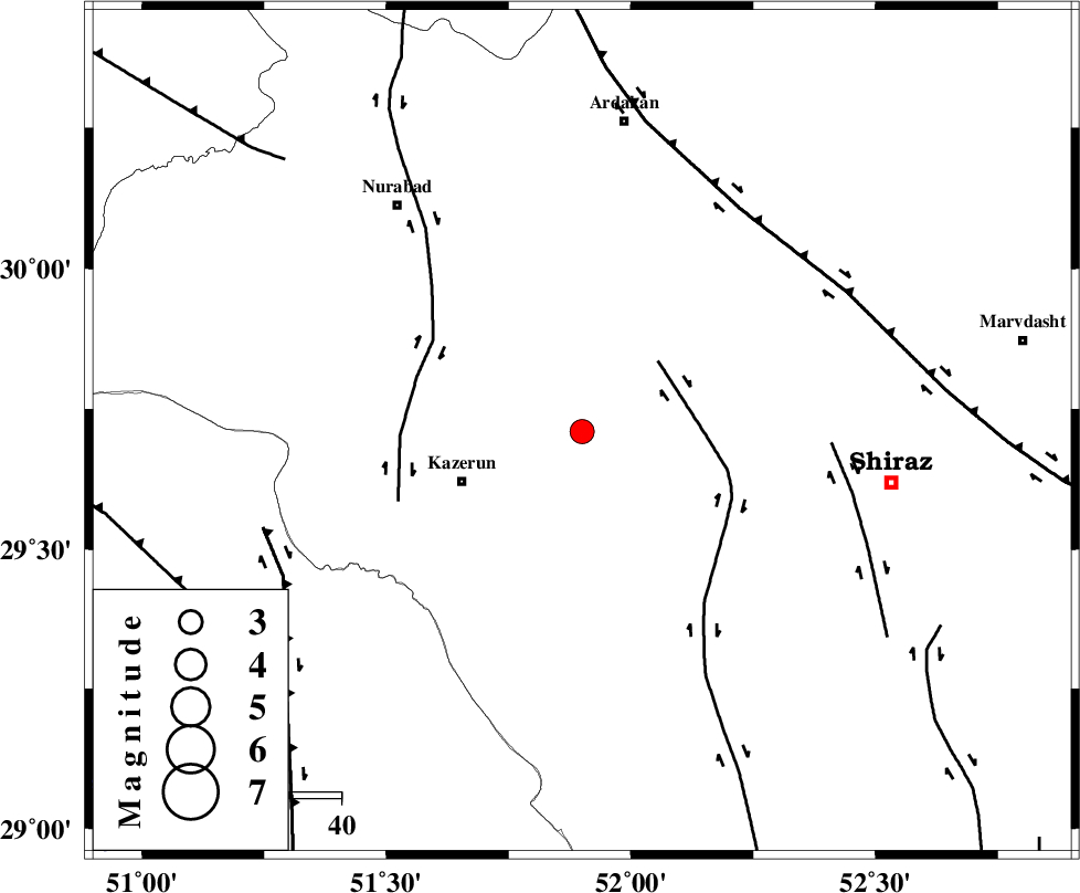
:3.1 |
| Date & Time (UTC) | 2021-01-14 17:38:04.1 |
| Date & Time (Local) | 1399/10/25 21:08:04.1 |
| Location | Lat:29.71 Lon: 51.9 |
| Region | Fars Province, 26 km -East of Kazerun |
Nearest Cities |
|
| 14 km North of Kalani, Fars Province | |
| 22 km East of Nodan, Fars Province | |
| 26 km North East of Kazerun, Fars Province | |
| 28 km East of Seyyed hasan, Fars Province | |
| 29 km North East of Mehranjan, Fars Province | |
| Depth | 10 km |
| Agency | |
Faults within 150 km: |
|
| KAREBASS_F (Length: 98 km) , Distance to epicenter: 21 km | |
| KAZERUN_F (Length: 96 km) , Distance to epicenter: 34 km | |
| SABZ_PUSHAN_F_Z3 (Length: 37 km) , Distance to epicenter: 49 km | |
| Number of Phases | 6 |
| RMS | 0.5 |
| Number of Stations | 6 |
| Error in Latitude | >3 km |
| Error in Longitude | 0 km |
| Error in Depth | 16 km |
Download waveform in seisan format
to download seisan software Click here
to access information about IIEES stations Click here
Amplitude | ||||||||
| UID | Agency | Station | Component | Amplitude | Period | Arrival Time | Proccessing Time | Signal Clip |
| 160936 | IIEES SC | AHRM | Z | 64 | 1 | 2021-01-14 17:38:43 | 2021-01-16 12:34:00 | n |
| 160937 | IIEES SC | KLNJ | Z | 290 | 1 | 2021-01-14 17:38:56 | 2021-01-16 12:34:00 | n |
| 160938 | IIEES SC | YZKH | Z | 13 | 1 | 2021-01-14 17:40:12 | 2021-01-16 12:34:00 | n |
| 160939 | IIEES SC | GTMR | Z | 44 | 1 | 2021-01-14 17:40:32 | 2021-01-16 12:34:00 | n |
| 160940 | IIEES SC | KHMZ | Z | 14 | 1 | 2021-01-14 17:40:51 | 2021-01-16 12:34:00 | n |
Phase | ||||||||||||
| Agency | Station | Component | Phase Type | Phase Quality | First Motion | Observed Arrival Time | Time Residual | Loc. Flag | Input Weight | Distance | Azimuth | |
| IIEES SC | AHRM | Z | IP | I | 2021-01-14 17:38:22 | 0 | y | 111 | 212 | |||
| IIEES SC | KLNJ | Z | IP | I | 2021-01-14 17:38:27 | -1 | y | 144 | 348 | |||
| IIEES SC | MEH | Z | IP | I | 2021-01-14 17:38:52 | 0.2 | y | 322 | 54 | |||
| IIEES SC | YZKH | Z | IP | I | 2021-01-14 17:39:00 | -0.9 | y | 389 | 41 | |||
| IIEES SC | GTMR | Z | IP | I | 2021-01-14 17:39:03 | 0.6 | y | 411 | 319 | |||
| IIEES SC | KHMZ | Z | IP | I | 2021-01-14 17:39:13 | 0.9 | y | 478 | 338 | |||
کلیه حقوق مادی و معنوی این سایت متعلق به پژوهشگاه بین المللی زلزله شناسی و مهندسی زلزله می باشد.
