خانه / مشخصات زلزله
Magnitude |
:3 |
| Date & Time (UTC) | 2021-02-19 04:27:39.7 |
| Date & Time (Local) | 1399/12/1 07:57:39.7 |
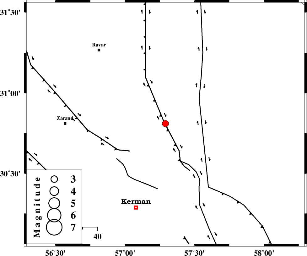
| Location | Lat:30.81 Lon: 57.291 |
| Region | Kerman Province, 69 km -East of Zarand |
Nearest Cities |
|
| 23 km North East of Harjand, Kerman Province | |
| 31 km North East of Hejdak, Kerman Province | |
| 34 km North of Dehlulu, Kerman Province | |
| 43 km North East of Hutak, Kerman Province | |
| 43 km North East of Chatrud, Kerman Province | |
| Depth | 17 km |
| Agency | |
Faults within 150 km: |
|
| LAKARKUH_F (Length: 138 km) , Distance to epicenter: 2 km | |
| GOLBAF_SIRCH_F (Length: 114 km) , Distance to epicenter: 28 km | |
| NAYBAND_F (Length: 258 km) , Distance to epicenter: 29 km | |
| Number of Phases | 6 |
| RMS | 0.3 |
| Number of Stations | 6 |
| Error in Latitude | >5.3 km |
| Error in Longitude | 5.3 km |
| Error in Depth | 777.1 km |
Download waveform in seisan format
to download seisan software Click here
to access information about IIEES stations Click here
Amplitude | ||||||||
| UID | Agency | Station | Component | Amplitude | Period | Arrival Time | Proccessing Time | Signal Clip |
| 162018 | IIEES SC | BSRN | Z | 0.2 | 1 | 2021-02-19 04:28:14 | 2021-02-20 09:14:00 | n |
| 162019 | IIEES SC | MEH | Z | 0.1 | 1 | 2021-02-19 04:28:19 | 2021-02-20 09:14:00 | n |
| 162020 | IIEES SC | YZKH | Z | 0.07 | 1 | 2021-02-19 04:28:26 | 2021-02-20 09:14:00 | n |
| 162021 | IIEES SC | TABS | Z | 0.08 | 1 | 2021-02-19 04:28:25 | 2021-02-20 09:14:00 | n |
Phase | ||||||||||||
| Agency | Station | Component | Phase Type | Phase Quality | First Motion | Observed Arrival Time | Time Residual | Loc. Flag | Input Weight | Distance | Azimuth | |
| IIEES SC | KRBR | Z | EPg | E | 2021-02-19 04:27:51 | -5.6 | n | 4 | 105 | 209 | ||
| IIEES SC | BSRN | Z | EPn | E | 2021-02-19 04:28:14 | 0.3 | y | 0 | 216 | 54 | ||
| IIEES SC | MEH | Z | EPn | E | 2021-02-19 04:28:19 | -0.1 | y | 0 | 264 | 284 | ||
| IIEES SC | YZKH | Z | EPn | E | 2021-02-19 04:28:26 | 0.6 | y | 0 | 310 | 304 | ||
| IIEES SC | TABS | Z | EPn | E | 2021-02-19 04:28:25 | -0.7 | y | 0 | 315 | 357 | ||
| IIEES SC | ZHSF | Z | EPn | E | 2021-02-19 04:28:31 | -0.1 | y | 0 | 361 | 112 | ||
کلیه حقوق مادی و معنوی این سایت متعلق به پژوهشگاه بین المللی زلزله شناسی و مهندسی زلزله می باشد.
