خانه / مشخصات زلزله
Magnitude |
:3.1 |
| Date & Time (UTC) | 2021-02-26 04:59:49.3 |
| Date & Time (Local) | 1399/12/8 08:29:49.3 |
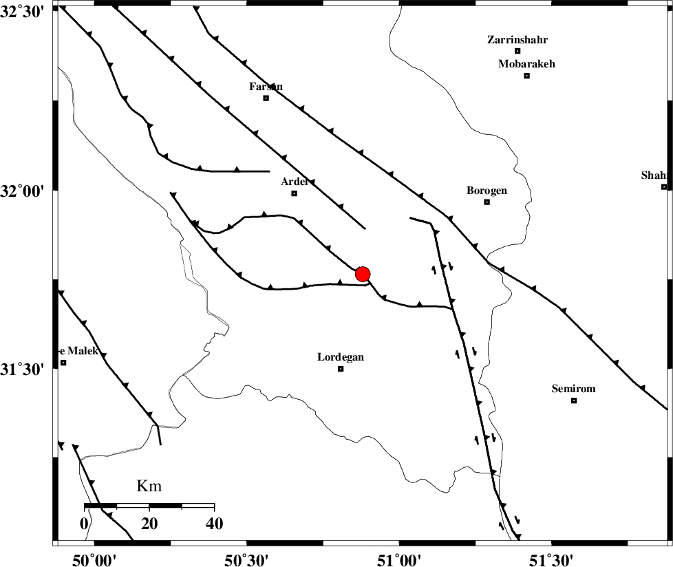
| Location | Lat:31.765 Lon: 50.88 |
| Region | Chaharmahal Bakhtiari Province, 30 km North of Lordegan |
Nearest Cities |
|
| 17 km North of Armand-e olia, Chaharmahal Bakhtiari Province | |
| 23 km South East of Naghan, Chaharmahal Bakhtiari Province | |
| 24 km South West of Baladaji, Chaharmahal Bakhtiari Province | |
| 28 km West of Gandoman, Chaharmahal Bakhtiari Province | |
| 29 km North West of Aluni, Chaharmahal Bakhtiari Province | |
| Depth | 10 km |
| Agency | |
Faults within 150 km: |
|
| DOPOLAN_F (Length: 107 km) , Distance to epicenter: 0 km | |
| SABZKUH_F (Length: 67 km) , Distance to epicenter: 4 km | |
| ARDAL_F (Length: 170 km) , Distance to epicenter: 14 km | |
| Number of Phases | 9 |
| RMS | 0.3 |
| Number of Stations | 9 |
| Error in Latitude | >1.5 km |
| Error in Longitude | 1.5 km |
| Error in Depth | 5.9 km |
Download waveform in seisan format
to download seisan software Click here
to access information about IIEES stations Click here
Amplitude | ||||||||
| UID | Agency | Station | Component | Amplitude | Period | Arrival Time | Proccessing Time | Signal Clip |
| 162163 | IIEES SC | AMIS | Z | 0.9 | 1 | 2021-02-26 05:00:14 | 2021-02-27 07:00:00 | n |
| 162164 | IIEES SC | YZKH | Z | 0.05 | 1 | 2021-02-26 05:00:42 | 2021-02-27 07:00:00 | n |
| 162165 | IIEES SC | ILBA | Z | 0.03 | 1 | 2021-02-26 05:00:56 | 2021-02-27 07:00:00 | n |
Phase | ||||||||||||
| Agency | Station | Component | Phase Type | Phase Quality | First Motion | Observed Arrival Time | Time Residual | Loc. Flag | Input Weight | Distance | Azimuth | |
| IIEES SC | KLNJ | Z | EPg | E | 2021-02-26 05:00:04 | -3.5 | n | 4 | 108 | 141 | ||
| IIEES SC | AMIS | Z | EPg | E | 2021-02-26 05:00:14 | 0.1 | y | 0 | 152 | 266 | ||
| IIEES SC | GTMR | Z | EPg | E | 2021-02-26 05:00:19 | 0.3 | y | 0 | 184 | 295 | ||
| IIEES SC | NASN | Z | EPn | E | 2021-02-26 05:00:24 | 0.3 | y | 0 | 215 | 58 | ||
| IIEES SC | GHVR | Z | EPn | E | 2021-02-26 05:00:35 | -0.1 | y | 0 | 303 | 6 | ||
| IIEES SC | MEH | Z | EPn | E | 2021-02-26 05:00:41 | -0.1 | y | 0 | 357 | 97 | ||
| IIEES SC | YZKH | Z | EPn | E | 2021-02-26 05:00:42 | 0.3 | y | 0 | 357 | 79 | ||
| IIEES SC | DAMV | Z | EPn | E | 2021-02-26 05:00:52 | -0.2 | y | 0 | 440 | 13 | ||
| IIEES SC | ILBA | Z | EPn | E | 2021-02-26 05:00:56 | -0.9 | y | 0 | 484 | 295 | ||
کلیه حقوق مادی و معنوی این سایت متعلق به پژوهشگاه بین المللی زلزله شناسی و مهندسی زلزله می باشد.
