خانه / مشخصات زلزله
Magnitude |
:3.1 |
| Date & Time (UTC) | 2021-04-05 12:42:05.4 |
| Date & Time (Local) | 1400/1/16 17:12:05.4 |
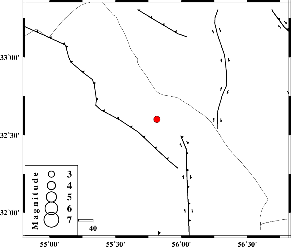
| Location | Lat:32.601 Lon: 55.814 |
| Region | Yazd Province, 118 km North-East of Bafq |
Nearest Cities |
|
| 52 km South East of Robat-e posht-e badam, Yazd Province | |
| 84 km North West of Behabad, Yazd Province | |
| 96 km North of Kushk, Yazd Province | |
| 100 km North West of Benestan, Yazd Province | |
| 100 km South East of Hajiabad, Yazd Province | |
| Depth | 21 km |
| Agency | |
Faults within 150 km: |
|
| SARBALA_F (Length: 92 km) , Distance to epicenter: 8 km | |
| NAINI_F (Length: 342 km) , Distance to epicenter: 14 km | |
| CHESHMEH_ROSTAM_ (Length: 142 km) , Distance to epicenter: 24 km | |
| Number of Phases | 7 |
| RMS | 0.3 |
| Number of Stations | 7 |
| Error in Latitude | >2.1 km |
| Error in Longitude | 2.1 km |
| Error in Depth | 4.8 km |
Download waveform in seisan format
to download seisan software Click here
to access information about IIEES stations Click here
Amplitude | ||||||||
| UID | Agency | Station | Component | Amplitude | Period | Arrival Time | Proccessing Time | Signal Clip |
| 162407 | IIEES SC | TABS | Z | 0.6 | 1 | 2021-04-05 12:42:32 | 2021-04-06 04:32:00 | n |
| 162408 | IIEES SC | BSRN | Z | 0.09 | 1 | 2021-04-05 12:42:52 | 2021-04-06 04:32:00 | n |
| 162409 | IIEES SC | SHRT | Z | 0.04 | 1 | 2021-04-05 12:43:06 | 2021-04-06 04:32:00 | n |
Phase | ||||||||||||
| Agency | Station | Component | Phase Type | Phase Quality | First Motion | Observed Arrival Time | Time Residual | Loc. Flag | Input Weight | Distance | Azimuth | |
| IIEES SC | YZKH | Z | EPg | E | 2021-04-05 12:42:24 | -0.3 | y | 0 | 117 | 258 | ||
| IIEES SC | TABS | Z | EPg | E | 2021-04-05 12:42:32 | 0.2 | y | 0 | 168 | 46 | ||
| IIEES SC | MEH | Z | EPg | E | 2021-04-05 12:42:34 | 0.6 | y | 0 | 176 | 220 | ||
| IIEES SC | KRBR | Z | EPn | E | 2021-04-05 12:42:50 | -0.2 | y | 0 | 304 | 163 | ||
| IIEES SC | BSRN | Z | EPn | E | 2021-04-05 12:42:52 | -0.2 | y | 0 | 320 | 103 | ||
| IIEES SC | SHRO | Z | EPn | E | 2021-04-05 12:42:59 | 0.1 | y | 0 | 378 | 3 | ||
| IIEES SC | SHRT | Z | EPn | E | 2021-04-05 12:43:06 | 0.4 | y | 0 | 434 | 74 | ||
کلیه حقوق مادی و معنوی این سایت متعلق به پژوهشگاه بین المللی زلزله شناسی و مهندسی زلزله می باشد.
