خانه / مشخصات زلزله
Magnitude |
:3.3 |
| Date & Time (UTC) | 2021-06-06 05:55:43.9 |
| Date & Time (Local) | 1400/3/16 10:25:43.9 |
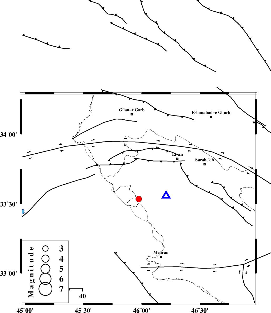
| Location | Lat:33.536 Lon: 45.975 |
| Region | Ilam Province, 44 km South-West of Ilam |
Nearest Cities |
|
| 21 km North West of Salehabad, Ilam Province | |
| 32 km South West of Chavar, Ilam Province | |
| 44 km South West of Ilam, Ilam Province | |
| 44 km South West of Eyvan, Ilam Province | |
| 47 km North West of Mehr, Ilam Province | |
| Depth | 12 km |
| Agency | |
Faults within 150 km: |
|
| ZFF4 (Length: 128 km) , Distance to epicenter: 9 km | |
| MFF7 (Length: 99 km) , Distance to epicenter: 14 km | |
| MFF6 (Length: 144 km) , Distance to epicenter: 48 km | |
| Number of Phases | 6 |
| RMS | 0.5 |
| Number of Stations | 6 |
| Error in Latitude | >33.5 km |
| Error in Longitude | 46 km |
| Error in Depth | 12 km |
Download waveform in seisan format
to download seisan software Click here
to access information about IIEES stations Click here
Amplitude | ||||||||
| UID | Agency | Station | Component | Amplitude | Period | Arrival Time | Proccessing Time | Signal Clip |
| 163543 | IIEES SC | SNGE | Z | 0.3 | 1 | 2021-06-06 05:56:19 | 2021-06-07 06:04:00 | n |
| 163544 | IIEES SC | GTMR | Z | 0.1 | 1 | 2021-06-06 05:56:30 | 2021-06-07 06:04:00 | n |
| 163545 | IIEES SC | MAHB | Z | 0.1 | 1 | 2021-06-06 05:56:36 | 2021-06-07 06:04:00 | n |
| 163546 | IIEES SC | KLNJ | Z | 0.03 | 1 | 2021-06-06 05:57:07 | 2021-06-07 06:04:00 | n |
Phase | ||||||||||||
| Agency | Station | Component | Phase Type | Phase Quality | First Motion | Observed Arrival Time | Time Residual | Loc. Flag | Input Weight | Distance | Azimuth | |
| IIEES SC | SNGE | Z | EPn | E | 2021-06-06 05:56:19 | 0.5 | y | 0 | 214 | 36 | ||
| IIEES SC | GTMR | Z | EPn | E | 2021-06-06 05:56:30 | -0.5 | y | 0 | 316 | 112 | ||
| IIEES SC | MAHB | Z | EPn | E | 2021-06-06 05:56:36 | -0.4 | y | 0 | 359 | 356 | ||
| IIEES SC | AZR | Z | EPn | E | 2021-06-06 05:57:05 | 16.5 | n | 4 | 460 | 0 | ||
| IIEES SC | GHVR | Z | EPn | E | 2021-06-06 05:56:57 | 3.4 | n | 4 | 498 | 78 | ||
| IIEES SC | KLNJ | Z | EPn | E | 2021-06-06 05:57:07 | 0.6 | y | 0 | 599 | 118 | ||
کلیه حقوق مادی و معنوی این سایت متعلق به پژوهشگاه بین المللی زلزله شناسی و مهندسی زلزله می باشد.
