خانه / مشخصات زلزله
Magnitude |
:3 |
| Date & Time (UTC) | 2021-07-18 17:08:08.1 |
| Date & Time (Local) | 1400/4/27 21:38:08.1 |
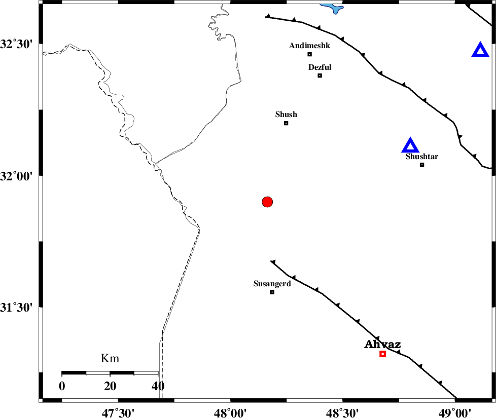
| Location | Lat:31.9 Lon: 48.164 |
| Region | Khoozestan Province, 38 km North of Susangerd |
Nearest Cities |
|
| 22 km North West of Abdolkhan-eali, Khoozestan Province | |
| 26 km North East of Bostan, Khoozestan Province | |
| 33 km South West of Amaleh teimur, Khoozestan Province | |
| 34 km South of Shush, Khoozestan Province | |
| 38 km North of Susangerd, Khoozestan Province | |
| Depth | 12 km |
| Agency | |
Faults within 150 km: |
|
| AHVAZ_F (Length: 99 km) , Distance to epicenter: 25 km | |
| DEZFUL_EMBAYMENT (Length: 228 km) , Distance to epicenter: 72 km | |
| BALARUD_F_Z1 (Length: 87 km) , Distance to epicenter: 95 km | |
| Number of Phases | 8 |
| RMS | 0.4 |
| Number of Stations | 8 |
| Error in Latitude | >3.7 km |
| Error in Longitude | 3.7 km |
| Error in Depth | 22.4 km |
Download waveform in seisan format
to download seisan software Click here
to access information about IIEES stations Click here
Amplitude | ||||||||
| UID | Agency | Station | Component | Amplitude | Period | Arrival Time | Proccessing Time | Signal Clip |
| 164294 | IIEES SC | GTMR | Z | 0.9 | 1 | 2021-07-18 17:08:26 | 2021-07-19 10:59:00 | n |
| 164295 | IIEES SC | KLNJ | Z | 0.1 | 1 | 2021-07-18 17:08:57 | 2021-07-19 10:59:00 | n |
| 164296 | IIEES SC | AHRM | Z | 0.02 | 1 | 2021-07-18 17:09:11 | 2021-07-19 10:59:00 | n |
| 164297 | IIEES SC | NASN | Z | 0.02 | 1 | 2021-07-18 17:09:11 | 2021-07-19 10:59:00 | n |
Phase | ||||||||||||
| Agency | Station | Component | Phase Type | Phase Quality | First Motion | Observed Arrival Time | Time Residual | Loc. Flag | Input Weight | Distance | Azimuth | |
| IIEES SC | GTMR | Z | EPg | E | 2021-07-18 17:08:26 | 0 | y | 0 | 110 | 55 | ||
| IIEES SC | KHMZ | Z | EPn | E | 2021-07-18 17:08:42 | -6.9 | n | 4 | 265 | 40 | ||
| IIEES SC | ILBA | Z | EPn | E | 2021-07-18 17:08:48 | -0.2 | y | 0 | 265 | 316 | ||
| IIEES SC | KLNJ | Z | EPn | E | 2021-07-18 17:08:57 | -0.6 | y | 0 | 341 | 107 | ||
| IIEES SC | GHVR | Z | EPn | E | 2021-07-18 17:09:06 | -0.1 | y | 0 | 406 | 45 | ||
| IIEES SC | AHRM | Z | EPn | E | 2021-07-18 17:09:11 | 0.4 | y | 0 | 441 | 140 | ||
| IIEES SC | QABG | Z | EPn | E | 2021-07-18 17:09:11 | 0.8 | y | 0 | 442 | 17 | ||
| IIEES SC | NASN | Z | EPn | E | 2021-07-18 17:09:11 | -0.8 | y | 0 | 448 | 77 | ||
کلیه حقوق مادی و معنوی این سایت متعلق به پژوهشگاه بین المللی زلزله شناسی و مهندسی زلزله می باشد.
