خانه / مشخصات زلزله
Magnitude |
:3 |
| Date & Time (UTC) | 2021-08-21 21:21:07.2 |
| Date & Time (Local) | 1400/5/31 01:51:07.2 |
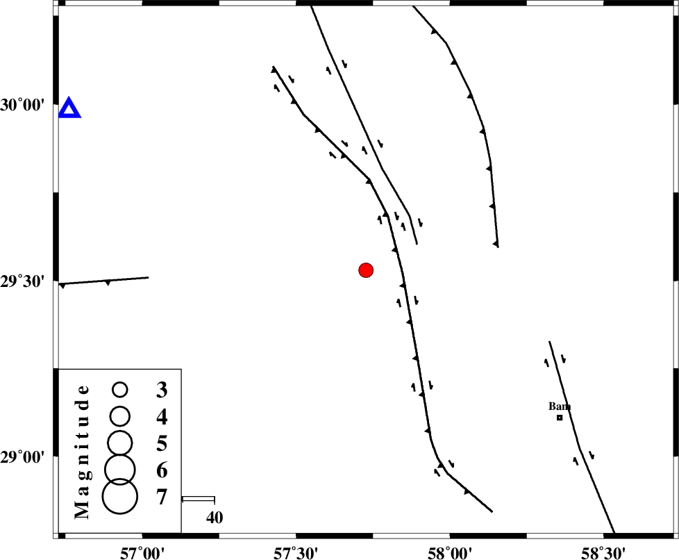
| Location | Lat:29.529 Lon: 57.727 |
| Region | Kerman Province, 96 km North of Jiroft |
Nearest Cities |
|
| 25 km East of Dehmirza, Kerman Province | |
| 29 km East of Rain, Kerman Province | |
| 33 km North East of Groh, Kerman Province | |
| 39 km South of Golbaft, Kerman Province | |
| 54 km South West of Geshit, Kerman Province | |
| Depth | 12 km |
| Agency | |
Faults within 150 km: |
|
| GOWK_F (Length: 152 km) , Distance to epicenter: 12 km | |
| GOLBAF_SIRCH_F (Length: 114 km) , Distance to epicenter: 18 km | |
| SHAHDAD_F (Length: 108 km) , Distance to epicenter: 42 km | |
| Number of Phases | 10 |
| RMS | 0.4 |
| Number of Stations | 10 |
| Error in Latitude | >1.8 km |
| Error in Longitude | 1.8 km |
| Error in Depth | 12.4 km |
Download waveform in seisan format
to download seisan software Click here
to access information about IIEES stations Click here
Amplitude | ||||||||
| UID | Agency | Station | Component | Amplitude | Period | Arrival Time | Proccessing Time | Signal Clip |
| 164833 | IIEES SC | BSRN | Z | 0.07 | 1 | 2021-08-21 21:21:52 | 2021-08-22 04:09:00 | n |
| 164834 | IIEES SC | YZKH | Z | 0.02 | 1 | 2021-08-21 21:22:10 | 2021-08-22 04:09:00 | n |
| 164835 | IIEES SC | TABS | Z | 0.03 | 1 | 2021-08-21 21:22:12 | 2021-08-22 04:09:00 | n |
Phase | ||||||||||||
| Agency | Station | Component | Phase Type | Phase Quality | First Motion | Observed Arrival Time | Time Residual | Loc. Flag | Input Weight | Distance | Azimuth | |
| IIEES SC | KRBR | Z | EPg | E | 2021-08-21 21:21:25 | -0.4 | y | 0 | 106 | 298 | ||
| IIEES SC | BNDS | Z | EPn | E | 2021-08-21 21:21:50 | 0 | y | 0 | 281 | 213 | ||
| IIEES SC | ZHSF | Z | EPn | E | 2021-08-21 21:21:30 | -21.1 | n | 4 | 295 | 88 | ||
| IIEES SC | BSRN | Z | EPn | E | 2021-08-21 21:21:52 | -0.3 | y | 0 | 301 | 26 | ||
| IIEES SC | MEH | Z | EPn | E | 2021-08-21 21:22:00 | -0.4 | y | 0 | 363 | 305 | ||
| IIEES SC | YZKH | Z | EPn | E | 2021-08-21 21:22:10 | 0.9 | y | 0 | 436 | 317 | ||
| IIEES SC | TABS | Z | EPn | E | 2021-08-21 21:22:12 | 0 | y | 0 | 460 | 353 | ||
| IIEES SC | GHIR | Z | EPn | E | 2021-08-21 21:22:15 | 0.5 | y | 0 | 482 | 253 | ||
| IIEES SC | SRVN | Z | EPn | E | 2021-08-21 21:22:18 | -0.2 | y | 0 | 515 | 117 | ||
| IIEES SC | SHRT | Z | EPn | E | 2021-08-21 21:22:19 | 0.5 | y | 0 | 517 | 28 | ||
کلیه حقوق مادی و معنوی این سایت متعلق به پژوهشگاه بین المللی زلزله شناسی و مهندسی زلزله می باشد.
