خانه / مشخصات زلزله
Magnitude |
:3.2 |
| Date & Time (UTC) | 2021-09-30 01:37:16.5 |
| Date & Time (Local) | 1400/7/8 05:07:16.5 |
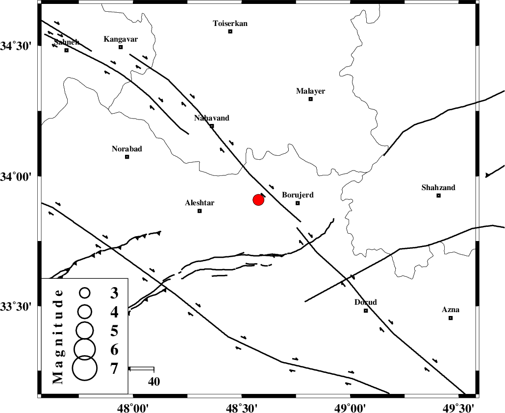
| Location | Lat:33.909 Lon: 48.577 |
| Region | Lorestan Province, 17 km -West of Borujerd |
Nearest Cities |
|
| 10 km of Bon dizeh, Lorestan Province | |
| 14 km South of Ashtarinan, Lorestan Province | |
| 17 km North West of Borujerd, Lorestan Province | |
| 17 km South of Jaefarabad, Lorestan Province | |
| 17 km North of Pellekan-e sofla, Lorestan Province | |
| Depth | 12 km |
| Agency | |
Faults within 150 km: |
|
| NAHAVAND_F (Length: 102 km) , Distance to epicenter: 9 km | |
| DORUD (Length: 100 km) , Distance to epicenter: 20 km | |
| SAHANEH_F (Length: 77 km) , Distance to epicenter: 41 km | |
| Number of Phases | 10 |
| RMS | 0.4 |
| Number of Stations | 10 |
| Error in Latitude | >3.7 km |
| Error in Longitude | 3.7 km |
| Error in Depth | 22.5 km |
Download waveform in seisan format
to download seisan software Click here
to access information about IIEES stations Click here
Amplitude | ||||||||
| UID | Agency | Station | Component | Amplitude | Period | Arrival Time | Proccessing Time | Signal Clip |
| 165453 | IIEES SC | GHVR | Z | 0.4 | 1 | 2021-09-30 01:37:56 | 2021-10-02 08:23:00 | n |
| 165454 | IIEES SC | CHTH | Z | 0.09 | 1 | 2021-09-30 01:38:05 | 2021-10-02 08:23:00 | n |
| 165455 | IIEES SC | NASN | Z | 0.04 | 1 | 2021-09-30 01:38:15 | 2021-10-02 08:23:00 | n |
Phase | ||||||||||||
| Agency | Station | Component | Phase Type | Phase Quality | First Motion | Observed Arrival Time | Time Residual | Loc. Flag | Input Weight | Distance | Azimuth | |
| IIEES SC | KHMZ | Z | EPg | E | 2021-09-30 01:37:34 | -4.1 | n | 4 | 130 | 98 | ||
| IIEES SC | GTMR | Z | EPg | E | 2021-09-30 01:37:43 | -0.1 | y | 0 | 167 | 163 | ||
| IIEES SC | QABG | Z | EPn | E | 2021-09-30 01:37:51 | -0.9 | y | 0 | 220 | 25 | ||
| IIEES SC | ILBA | Z | EPn | E | 2021-09-30 01:37:52 | 0.1 | y | 0 | 222 | 262 | ||
| IIEES SC | GHVR | Z | EPn | E | 2021-09-30 01:37:56 | 0.3 | y | 0 | 254 | 76 | ||
| IIEES SC | ZNJK | Z | EPn | E | 2021-09-30 01:38:01 | -0.8 | y | 0 | 307 | 2 | ||
| IIEES SC | GZV | Z | EPn | E | 2021-09-30 01:38:04 | 0.7 | y | 0 | 313 | 29 | ||
| IIEES SC | CHTH | Z | EPn | E | 2021-09-30 01:38:05 | 0.6 | y | 0 | 322 | 46 | ||
| IIEES SC | SRSL | Z | EPn | E | 2021-09-30 01:38:14 | 2.4 | n | 4 | 384 | 312 | ||
| IIEES SC | NASN | Z | EPn | E | 2021-09-30 01:38:15 | -0.2 | y | 0 | 413 | 107 | ||
کلیه حقوق مادی و معنوی این سایت متعلق به پژوهشگاه بین المللی زلزله شناسی و مهندسی زلزله می باشد.
