خانه / مشخصات زلزله
Magnitude |
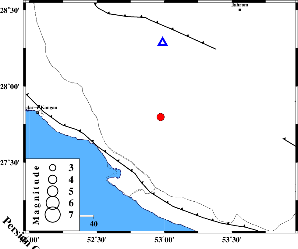
:3.5 |
| Date & Time (UTC) | 2021-10-31 07:49:13.3 |
| Date & Time (Local) | 1400/8/9 11:19:13.3 |
| Location | Lat:27.798 Lon: 52.972 |
| Region | Fars Province, 29 km North of Mehr |
Nearest Cities |
|
| 20 km North of Alamarvdasht, Fars Province | |
| 29 km North East of Ardavan-e olia, Fars Province | |
| 29 km North of Mehr, Fars Province | |
| 30 km North East of Asir, Fars Province | |
| 33 km South East of Garmesht, Fars Province | |
| Depth | 10 km |
| Agency | |
Faults within 150 km: |
|
| MFF3 (Length: 292 km) , Distance to epicenter: 45 km | |
| QIR_F (Length: 130 km) , Distance to epicenter: 64 km | |
| LAR_F (Length: 99 km) , Distance to epicenter: 90 km | |
| Number of Phases | 9 |
| RMS | 0.3 |
| Number of Stations | 9 |
| Error in Latitude | >3.7 km |
| Error in Longitude | 3.7 km |
| Error in Depth | 8.1 km |
Download waveform in seisan format
to download seisan software Click here
to access information about IIEES stations Click here
Amplitude | ||||||||
| UID | Agency | Station | Component | Amplitude | Period | Arrival Time | Proccessing Time | Signal Clip |
| 166005 | IIEES SC | LMD1 | Z | 7 | 1 | 2021-10-31 07:49:23 | 2021-11-01 06:52:00 | n |
| 166006 | IIEES SC | KRBR | Z | 0.1 | 1 | 2021-10-31 07:50:16 | 2021-11-01 06:52:00 | n |
| 166007 | IIEES SC | YZKH | Z | 0.03 | 1 | 2021-10-31 07:50:27 | 2021-11-01 06:52:00 | n |
Phase | ||||||||||||
| Agency | Station | Component | Phase Type | Phase Quality | First Motion | Observed Arrival Time | Time Residual | Loc. Flag | Input Weight | Distance | Azimuth | |
| IIEES SC | GHIR | Z | EPg | E | 2021-10-31 07:49:30 | 7.5 | n | 4 | 54 | 2 | ||
| IIEES SC | LMD1 | Z | EPg | E | 2021-10-31 07:49:23 | 0 | y | 0 | 54 | 159 | ||
| IIEES SC | AHRM | Z | EPn | E | 2021-10-31 07:49:48 | 0 | y | 0 | 216 | 303 | ||
| IIEES SC | BNDS | Z | EPn | E | 2021-10-31 07:50:01 | 0.3 | y | 0 | 319 | 98 | ||
| IIEES SC | KLNJ | Z | EPn | E | 2021-10-31 07:50:09 | 0.5 | y | 0 | 380 | 339 | ||
| IIEES SC | MEH | Z | EPn | E | 2021-10-31 07:50:20 | 6.1 | n | 4 | 429 | 22 | ||
| IIEES SC | KRBR | Z | EPn | E | 2021-10-31 07:50:16 | -0.5 | y | 0 | 442 | 57 | ||
| IIEES SC | YZKH | Z | EPn | E | 2021-10-31 07:50:27 | 0 | y | 0 | 532 | 17 | ||
| IIEES SC | GTMR | Z | EPn | E | 2021-10-31 07:50:39 | -0.7 | y | 0 | 638 | 324 | ||
کلیه حقوق مادی و معنوی این سایت متعلق به پژوهشگاه بین المللی زلزله شناسی و مهندسی زلزله می باشد.
