خانه / مشخصات زلزله
Magnitude |
:3.4 |
| Date & Time (UTC) | 2021-11-28 17:52:01.4 |
| Date & Time (Local) | 1400/9/7 21:22:01.4 |
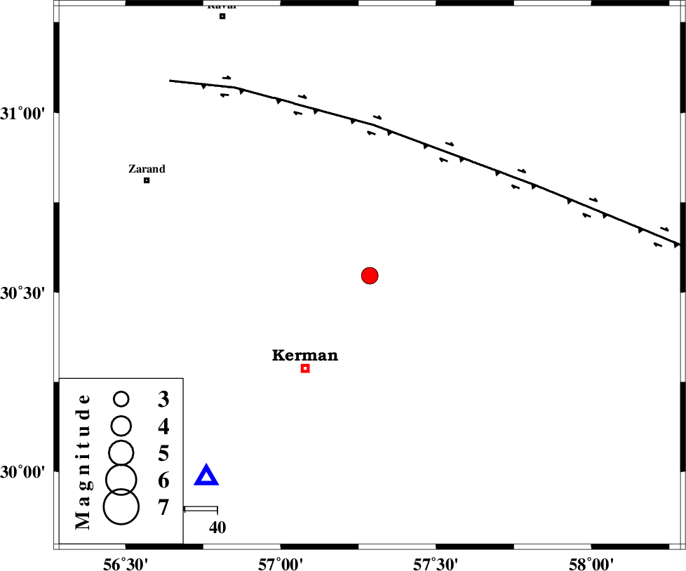
| Location | Lat:30.546 Lon: 57.286 |
| Region | Kerman Province, 35 km North-East of Kerman |
Nearest Cities |
|
| 5 km North of Dehlulu, Kerman Province | |
| 19 km South East of Harjand, Kerman Province | |
| 33 km North East of Sarasiyab-e ferangi, Kerman Province | |
| 34 km East of Hutak, Kerman Province | |
| 35 km North East of Kerman, Kerman Province | |
| Depth | 7 km |
| Agency | |
Faults within 150 km: |
|
| LAKARKUH_F (Length: 138 km) , Distance to epicenter: 11 km | |
| GOLBAF_SIRCH_F (Length: 114 km) , Distance to epicenter: 11 km | |
| CHATRUD_F (Length: 37 km) , Distance to epicenter: 16 km | |
| Number of Phases | 6 |
| RMS | 0.1 |
| Number of Stations | 6 |
| Error in Latitude | >1.3 km |
| Error in Longitude | 1.3 km |
| Error in Depth | 3.1 km |
Download waveform in seisan format
to download seisan software Click here
to access information about IIEES stations Click here
Amplitude | ||||||||
| UID | Agency | Station | Component | Amplitude | Period | Arrival Time | Proccessing Time | Signal Clip |
| 166893 | IIEES SC | KRBR | Z | 5 | 1 | 2021-11-28 17:52:15 | 2021-11-29 07:07:00 | n |
| 166894 | IIEES SC | YZKH | Z | 0.2 | 1 | 2021-11-28 17:52:50 | 2021-11-29 07:07:00 | n |
| 166895 | IIEES SC | TABS | Z | 0.2 | 1 | 2021-11-28 17:52:52 | 2021-11-29 07:07:00 | n |
| 166896 | IIEES SC | SHRT | Z | 0.04 | 1 | 2021-11-28 17:53:04 | 2021-11-29 07:07:00 | n |
Phase | ||||||||||||
| Agency | Station | Component | Phase Type | Phase Quality | First Motion | Observed Arrival Time | Time Residual | Loc. Flag | Input Weight | Distance | Azimuth | |
| IIEES SC | KRBR | Z | EPg | E | 2021-11-28 17:52:15 | 0 | y | 0 | 80 | 219 | ||
| IIEES SC | YZKH | Z | EPn | E | 2021-11-28 17:52:50 | 0.1 | y | 0 | 328 | 309 | ||
| IIEES SC | TABS | Z | EPn | E | 2021-11-28 17:52:52 | -0.1 | y | 0 | 344 | 357 | ||
| IIEES SC | BNDS | Z | EPn | E | 2021-11-28 17:52:55 | -0.1 | y | 0 | 365 | 197 | ||
| IIEES SC | SHRT | Z | EPn | E | 2021-11-28 17:53:04 | -0.3 | y | 0 | 446 | 40 | ||
| IIEES SC | SRVN | Z | EPn | E | 2021-11-28 17:53:25 | 0.1 | y | 0 | 608 | 125 | ||
کلیه حقوق مادی و معنوی این سایت متعلق به پژوهشگاه بین المللی زلزله شناسی و مهندسی زلزله می باشد.
