خانه / مشخصات زلزله
Magnitude |
:3.1 |
| Date & Time (UTC) | 2022-02-26 02:03:40.4 |
| Date & Time (Local) | 1400/12/7 05:33:40.4 |
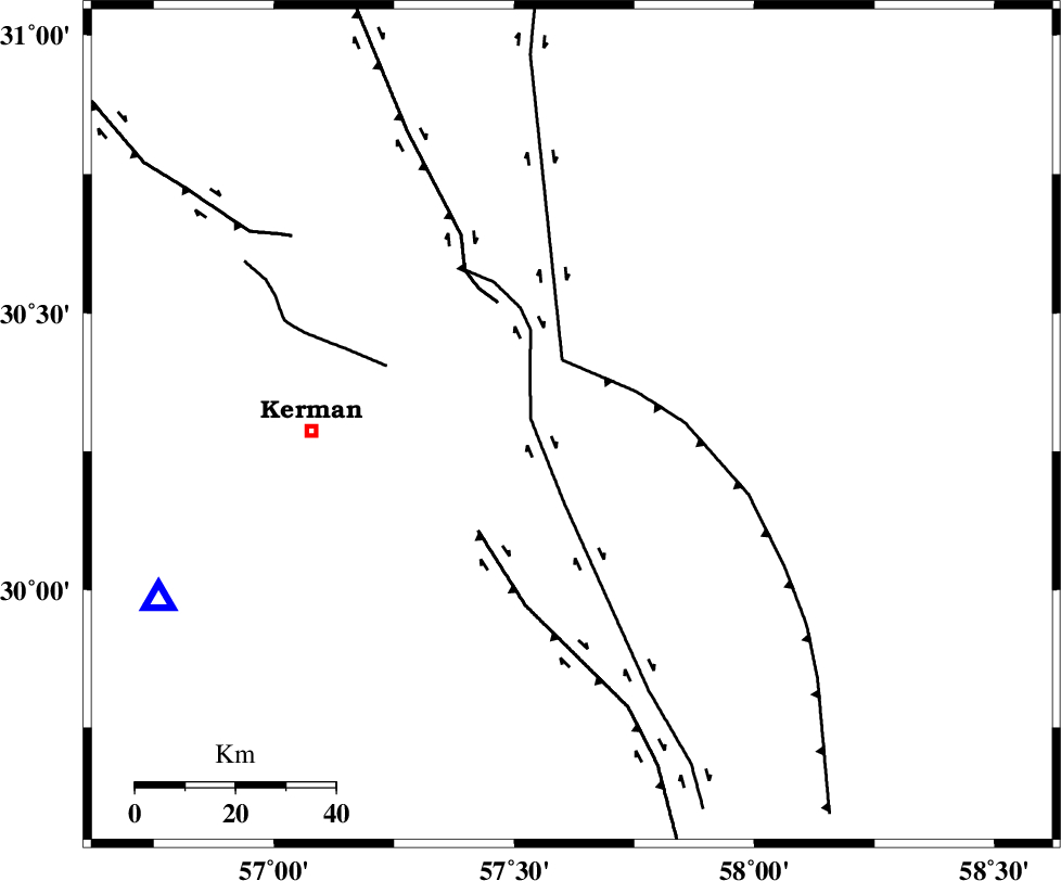
| Location | Lat:30.297 Lon: 57.62 |
| Region | Kerman Province, 52 km -East of Kerman |
Nearest Cities |
|
| 13 km North of Sirch, Kerman Province | |
| 15 km South of Shahdad, Kerman Province | |
| 21 km North of Jushan, Kerman Province | |
| 26 km South West of Estehkam, Kerman Province | |
| 40 km South East of Dehlulu, Kerman Province | |
| Depth | 12 km |
| Agency | |
Faults within 150 km: |
|
| GOLBAF_SIRCH_F (Length: 114 km) , Distance to epicenter: 8 km | |
| SHAHDAD_F (Length: 108 km) , Distance to epicenter: 13 km | |
| NAYBAND_F (Length: 258 km) , Distance to epicenter: 13 km | |
| Number of Phases | 7 |
| RMS | 0.4 |
| Number of Stations | 7 |
| Error in Latitude | >4.2 km |
| Error in Longitude | 4.2 km |
| Error in Depth | 11 km |
Download waveform in seisan format
to download seisan software Click here
to access information about IIEES stations Click here
Amplitude | ||||||||
| UID | Agency | Station | Component | Amplitude | Period | Arrival Time | Proccessing Time | Signal Clip |
| 168961 | IIEES SC | BSRN | Z | 0.3 | 1 | 2022-02-26 02:04:18 | 2022-02-26 07:39:00 | n |
| 168962 | IIEES SC | BSRN | Z | 0.3 | 1 | 2022-02-26 02:04:44 | 2022-02-26 07:39:00 | n |
| 168963 | IIEES SC | BNDS | Z | 0.06 | 1 | 2022-02-26 02:04:31 | 2022-02-26 07:39:00 | n |
| 168964 | IIEES SC | SHRT | Z | 0.03 | 1 | 2022-02-26 02:04:44 | 2022-02-26 07:39:00 | n |
Phase | ||||||||||||
| Agency | Station | Component | Phase Type | Phase Quality | First Motion | Observed Arrival Time | Time Residual | Loc. Flag | Input Weight | Distance | Azimuth | |
| IIEES SC | KRBR | Z | EPg | E | 2022-02-26 02:03:56 | 0 | y | 0 | 90 | 247 | ||
| IIEES SC | BSRN | Z | EPn | E | 2022-02-26 02:04:18 | 0.7 | y | 0 | 234 | 38 | ||
| IIEES SC | BSRN | Z | ES | E | 2022-02-26 02:04:44 | -0.1 | y | 0 | 234 | 38 | ||
| IIEES SC | BNDS | Z | EPn | E | 2022-02-26 02:04:31 | -0.1 | y | 0 | 351 | 204 | ||
| IIEES SC | YZKH | Z | EPn | E | 2022-02-26 02:04:35 | 0.6 | y | 0 | 370 | 309 | ||
| IIEES SC | TABS | Z | EPn | E | 2022-02-26 02:04:34 | -0.8 | y | 0 | 375 | 353 | ||
| IIEES SC | SHRT | Z | EPn | E | 2022-02-26 02:04:44 | 0 | y | 0 | 449 | 34 | ||
کلیه حقوق مادی و معنوی این سایت متعلق به پژوهشگاه بین المللی زلزله شناسی و مهندسی زلزله می باشد.
