خانه / مشخصات زلزله
Magnitude |
:3.1 |
| Date & Time (UTC) | 2021-03-23 05:18:25.8 |
| Date & Time (Local) | 1400/1/3 09:48:25.8 |
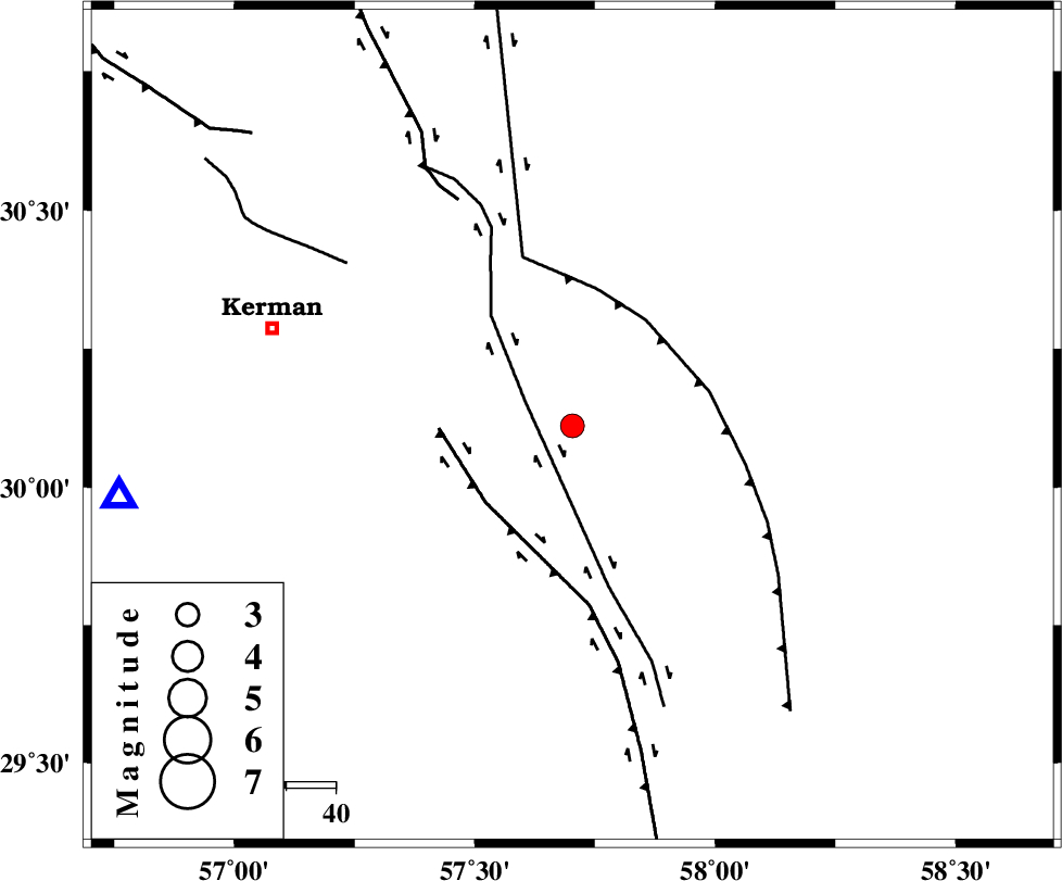
| Location | Lat:30.111 Lon: 57.703 |
| Region | Kerman Province, 63 km South-East of Kerman |
Nearest Cities |
|
| 8 km North of Jushan, Kerman Province | |
| 17 km East of Sirch, Kerman Province | |
| 27 km North of Golbaft, Kerman Province | |
| 34 km South of Shahdad, Kerman Province | |
| 38 km South West of Estehkam, Kerman Province | |
| Depth | 12 km |
| Agency | |
Faults within 150 km: |
|
| GOLBAF_SIRCH_F (Length: 114 km) , Distance to epicenter: 11 km | |
| GOWK_F (Length: 152 km) , Distance to epicenter: 23 km | |
| SHAHDAD_F (Length: 108 km) , Distance to epicenter: 26 km | |
| Number of Phases | 8 |
| RMS | 0.4 |
| Number of Stations | 8 |
| Error in Latitude | >3.8 km |
| Error in Longitude | 3.8 km |
| Error in Depth | 21.4 km |
Download waveform in seisan format
to download seisan software Click here
to access information about IIEES stations Click here
Amplitude | ||||||||
| UID | Agency | Station | Component | Amplitude | Period | Arrival Time | Proccessing Time | Signal Clip |
| 189578 | IIEES SC | KBAM | Z | 0.8 | 1 | 2021-03-23 05:18:47 | 2023-12-05 08:00:00 | n |
| 189579 | IIEES SC | YZKH | Z | 0.05 | 1 | 2021-03-23 05:19:22 | 2023-12-05 08:00:00 | n |
| 189580 | IIEES SC | SHRT | Z | 0.02 | 1 | 2021-03-23 05:19:31 | 2023-12-05 08:00:00 | n |
Phase | ||||||||||||
| Agency | Station | Component | Phase Type | Phase Quality | First Motion | Observed Arrival Time | Time Residual | Loc. Flag | Input Weight | Distance | Azimuth | |
| IIEES SC | KRBR | Z | EPg | E | 2021-03-23 05:18:27 | -14.8 | n | 4 | 92 | 261 | ||
| IIEES SC | KBAM | Z | EPg | E | 2021-03-23 05:18:47 | 0 | y | 0 | 130 | 146 | ||
| IIEES SC | BSRN | Z | EPn | E | 2021-03-23 05:19:03 | -0.8 | y | 0 | 246 | 33 | ||
| IIEES SC | MEH | Z | EPn | E | 2021-03-23 05:19:14 | -0.3 | y | 0 | 328 | 296 | ||
| IIEES SC | BNDS | Z | EPn | E | 2021-03-23 05:19:15 | 0.1 | y | 0 | 336 | 206 | ||
| IIEES SC | YZKH | Z | EPn | E | 2021-03-23 05:19:22 | -0.1 | y | 0 | 390 | 310 | ||
| IIEES SC | TABS | Z | EPn | E | 2021-03-23 05:19:23 | 0.8 | y | 0 | 396 | 352 | ||
| IIEES SC | SHRT | Z | EPn | E | 2021-03-23 05:19:31 | 0.5 | y | 0 | 462 | 32 | ||
کلیه حقوق مادی و معنوی این سایت متعلق به پژوهشگاه بین المللی زلزله شناسی و مهندسی زلزله می باشد.
