خانه / مشخصات زلزله
Magnitude |
:3 |
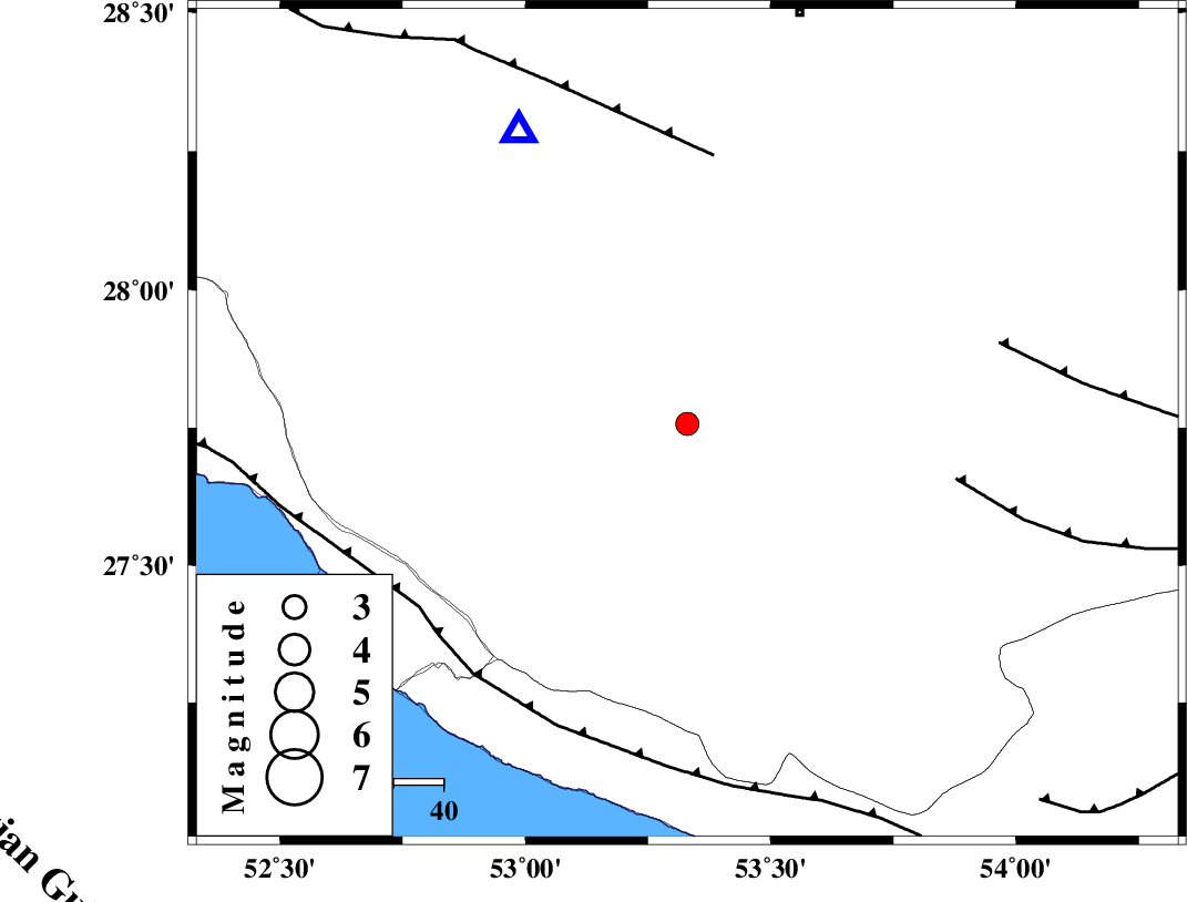
| Date & Time (UTC) | 2021-03-24 03:41:13.8 |
| Date & Time (Local) | 1400/1/4 08:11:13.8 |
| Location | Lat:27.757 Lon: 53.33 |
| Region | Fars Province, 50 km North-East of Lamerd |
Nearest Cities |
|
| 16 km South of Khonj, Fars Province | |
| 27 km North West of Fedagh, Fars Province | |
| 30 km North West of Ard, Fars Province | |
| 35 km West of Fishur, Fars Province | |
| 39 km North East of Alamarvdasht, Fars Province | |
| Depth | 15 km |
| Agency | |
Faults within 150 km: |
|
| QIR_F (Length: 130 km) , Distance to epicenter: 54 km | |
| LAR_F (Length: 99 km) , Distance to epicenter: 55 km | |
| BERIZ_F (Length: 49 km) , Distance to epicenter: 65 km | |
| Number of Phases | 7 |
| RMS | 0.4 |
| Number of Stations | 7 |
| Error in Latitude | >7.4 km |
| Error in Longitude | 7.4 km |
| Error in Depth | 21.4 km |
Download waveform in seisan format
to download seisan software Click here
to access information about IIEES stations Click here
Amplitude | ||||||||
| UID | Agency | Station | Component | Amplitude | Period | Arrival Time | Proccessing Time | Signal Clip |
| 189632 | IIEES SC | LMD1 | Z | 2 | 1 | 2021-03-24 03:41:22 | 2023-12-11 08:02:00 | n |
| 189633 | IIEES SC | KBAM | Z | 0.03 | 1 | 2021-03-24 03:42:26 | 2023-12-11 08:02:00 | n |
| 189634 | IIEES SC | YZKH | Z | 0.01 | 1 | 2021-03-24 03:42:26 | 2023-12-11 08:02:00 | n |
Phase | ||||||||||||
| Agency | Station | Component | Phase Type | Phase Quality | First Motion | Observed Arrival Time | Time Residual | Loc. Flag | Input Weight | Distance | Azimuth | |
| IIEES SC | LMD1 | Z | EPg | E | 2021-03-24 03:41:22 | -0.2 | y | 0 | 49 | 199 | ||
| IIEES SC | GHIR | Z | EPg | E | 2021-03-24 03:41:21 | -4.2 | n | 4 | 68 | 330 | ||
| IIEES SC | AHRM | Z | EPn | E | 2021-03-24 03:41:50 | 0.3 | y | 0 | 234 | 302 | ||
| IIEES SC | KLNJ | Z | EPn | E | 2021-03-24 03:42:10 | -1 | y | 0 | 398 | 335 | ||
| IIEES SC | MEH | Z | EPn | E | 2021-03-24 03:42:14 | 0.9 | y | 0 | 421 | 17 | ||
| IIEES SC | KBAM | Z | EPn | E | 2021-03-24 03:42:26 | 0.1 | y | 0 | 524 | 73 | ||
| IIEES SC | YZKH | Z | EPn | E | 2021-03-24 03:42:26 | -0.5 | y | 0 | 528 | 13 | ||
کلیه حقوق مادی و معنوی این سایت متعلق به پژوهشگاه بین المللی زلزله شناسی و مهندسی زلزله می باشد.
