خانه / مشخصات زلزله
Magnitude |
:3.2 |
| Date & Time (UTC) | 2020-09-02 04:27:17.8 |
| Date & Time (Local) | 1399/6/12 08:57:17.8 |
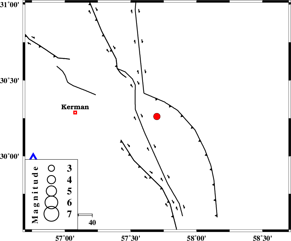
| Location | Lat:30.262 Lon: 57.698 |
| Region | Kerman Province, 60 km -East of Kerman |
Nearest Cities |
|
| 15 km North East of Sirch, Kerman Province | |
| 17 km South of Shahdad, Kerman Province | |
| 19 km North of Jushan, Kerman Province | |
| 23 km South West of Estehkam, Kerman Province | |
| 44 km North of Golbaft, Kerman Province | |
| Depth | 12 km |
| Agency | |
Faults within 150 km: |
|
| SHAHDAD_F (Length: 108 km) , Distance to epicenter: 12 km | |
| GOLBAF_SIRCH_F (Length: 114 km) , Distance to epicenter: 15 km | |
| NAYBAND_F (Length: 258 km) , Distance to epicenter: 19 km | |
| Number of Phases | 6 |
| RMS | 0.6 |
| Number of Stations | 6 |
| Error in Latitude | >4 km |
| Error in Longitude | 4 km |
| Error in Depth | 21.6 km |
Download waveform in seisan format
to download seisan software Click here
to access information about IIEES stations Click here
Amplitude | ||||||||
| UID | Agency | Station | Component | Amplitude | Period | Arrival Time | Proccessing Time | Signal Clip |
| 193852 | IIEES SC | KRBR | Z | 2 | 1 | 2020-09-02 04:27:33 | 2024-06-30 05:13:00 | n |
| 193853 | IIEES SC | BSRN | Z | 0.2 | 1 | 2020-09-02 04:27:55 | 2024-06-30 05:13:00 | n |
| 193854 | IIEES SC | BNDS | Z | 0.1 | 1 | 2020-09-02 04:28:10 | 2024-06-30 05:13:00 | n |
| 193855 | IIEES SC | YZKH | Z | 0.1 | 1 | 2020-09-02 04:28:12 | 2024-06-30 05:13:00 | n |
Phase | ||||||||||||
| Agency | Station | Component | Phase Type | Phase Quality | First Motion | Observed Arrival Time | Time Residual | Loc. Flag | Input Weight | Distance | Azimuth | |
| IIEES SC | KRBR | Z | EPg | E | 2020-09-02 04:27:33 | -0.8 | y | 0 | 96 | 251 | ||
| IIEES SC | BSRN | Z | EPn | E | 2020-09-02 04:27:55 | 0.4 | y | 0 | 233 | 36 | ||
| IIEES SC | ZHSF | Z | EPn | E | 2020-09-02 04:28:03 | -0.5 | y | 0 | 305 | 104 | ||
| IIEES SC | BNDS | Z | EPn | E | 2020-09-02 04:28:10 | 0.8 | y | 0 | 350 | 205 | ||
| IIEES SC | YZKH | Z | EPn | E | 2020-09-02 04:28:12 | -0.5 | y | 0 | 378 | 309 | ||
| IIEES SC | TABS | Z | EPn | E | 2020-09-02 04:28:13 | 0.3 | y | 0 | 380 | 352 | ||
کلیه حقوق مادی و معنوی این سایت متعلق به پژوهشگاه بین المللی زلزله شناسی و مهندسی زلزله می باشد.
