خانه / مشخصات زلزله
Magnitude |
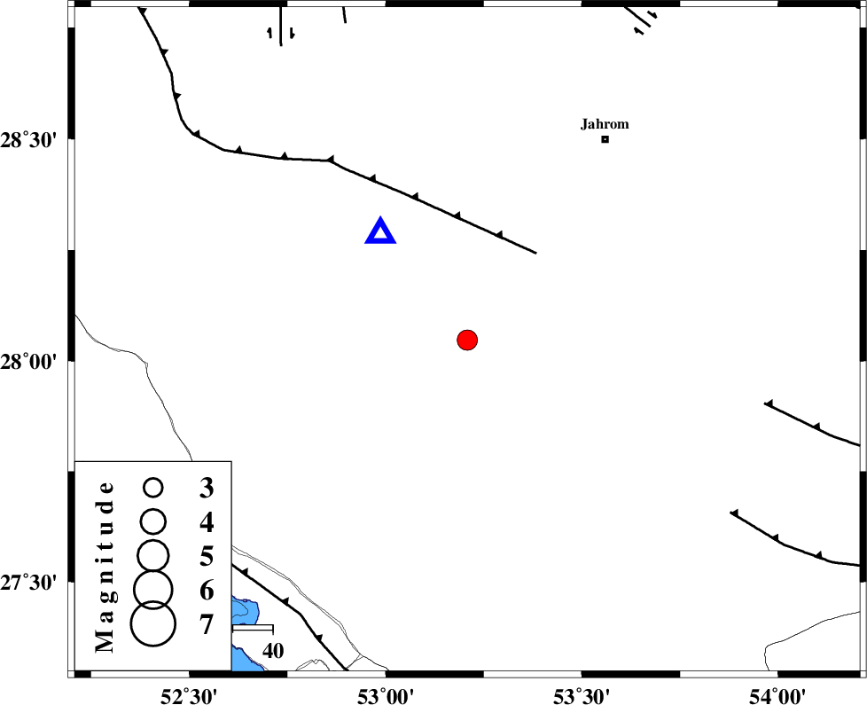
:3.2 |
| Date & Time (UTC) | 2020-08-31 21:12:48.4 |
| Date & Time (Local) | 1399/6/11 01:42:48.4 |
| Location | Lat:28.047 Lon: 53.208 |
| Region | Fars Province, 50 km South-East of Qir va Karzin |
Nearest Cities |
|
| 14 km South of Seyfabad, Fars Province | |
| 29 km North West of Khonj, Fars Province | |
| 37 km South West of Mobarakabad, Fars Province | |
| 40 km South West of Balafan, Fars Province | |
| 43 km South East of Shahrak-e jonubi, Fars Province | |
| Depth | 15 km |
| Agency | |
Faults within 150 km: |
|
| QIR_F (Length: 130 km) , Distance to epicenter: 28 km | |
| BERIZ_F (Length: 49 km) , Distance to epicenter: 76 km | |
| LAR_F (Length: 99 km) , Distance to epicenter: 79 km | |
| Number of Phases | 8 |
| RMS | 0.4 |
| Number of Stations | 8 |
| Error in Latitude | >3.7 km |
| Error in Longitude | 3.7 km |
| Error in Depth | 5.2 km |
Download waveform in seisan format
to download seisan software Click here
to access information about IIEES stations Click here
Amplitude | ||||||||
| UID | Agency | Station | Component | Amplitude | Period | Arrival Time | Proccessing Time | Signal Clip |
| 193866 | IIEES SC | BNDS | Z | 0.1 | 1 | 2020-08-31 21:13:33 | 2024-06-30 06:05:00 | n |
| 193867 | IIEES SC | YZKH | Z | 0.02 | 1 | 2020-08-31 21:13:58 | 2024-06-30 06:05:00 | n |
| 193868 | IIEES SC | NASN | Z | 0.02 | 1 | 2020-08-31 21:14:02 | 2024-06-30 06:05:00 | n |
| 193869 | IIEES SC | TABS | Z | 0.01 | 1 | 2020-08-31 21:14:25 | 2024-06-30 06:05:00 | n |
Phase | ||||||||||||
| Agency | Station | Component | Phase Type | Phase Quality | First Motion | Observed Arrival Time | Time Residual | Loc. Flag | Input Weight | Distance | Azimuth | |
| IIEES SC | GHIR | Z | EPg | E | 2020-08-31 21:12:55 | 0.1 | y | 0 | 34 | 321 | ||
| IIEES SC | AHRM | Z | EPn | E | 2020-08-31 21:13:21 | -0.3 | y | 0 | 208 | 296 | ||
| IIEES SC | BNDS | Z | EPn | E | 2020-08-31 21:13:33 | 0 | y | 0 | 301 | 104 | ||
| IIEES SC | KRBR | Z | EPn | E | 2020-08-31 21:13:47 | 0.2 | y | 0 | 407 | 58 | ||
| IIEES SC | YZKH | Z | EPn | E | 2020-08-31 21:13:58 | 0.2 | y | 0 | 500 | 15 | ||
| IIEES SC | NASN | Z | EPn | E | 2020-08-31 21:14:02 | 0.5 | y | 0 | 528 | 356 | ||
| IIEES SC | BSRN | Z | EPn | E | 2020-08-31 21:14:34 | 9.1 | n | 4 | 717 | 53 | ||
| IIEES SC | TABS | Z | EPn | E | 2020-08-31 21:14:25 | -0.9 | y | 0 | 725 | 31 | ||
کلیه حقوق مادی و معنوی این سایت متعلق به پژوهشگاه بین المللی زلزله شناسی و مهندسی زلزله می باشد.
