خانه / مشخصات زلزله
Magnitude |
:3.3 |
| Date & Time (UTC) | 2025-02-06 15:38:07.7 |
| Date & Time (Local) | 1403/11/18 19:08:07.7 |
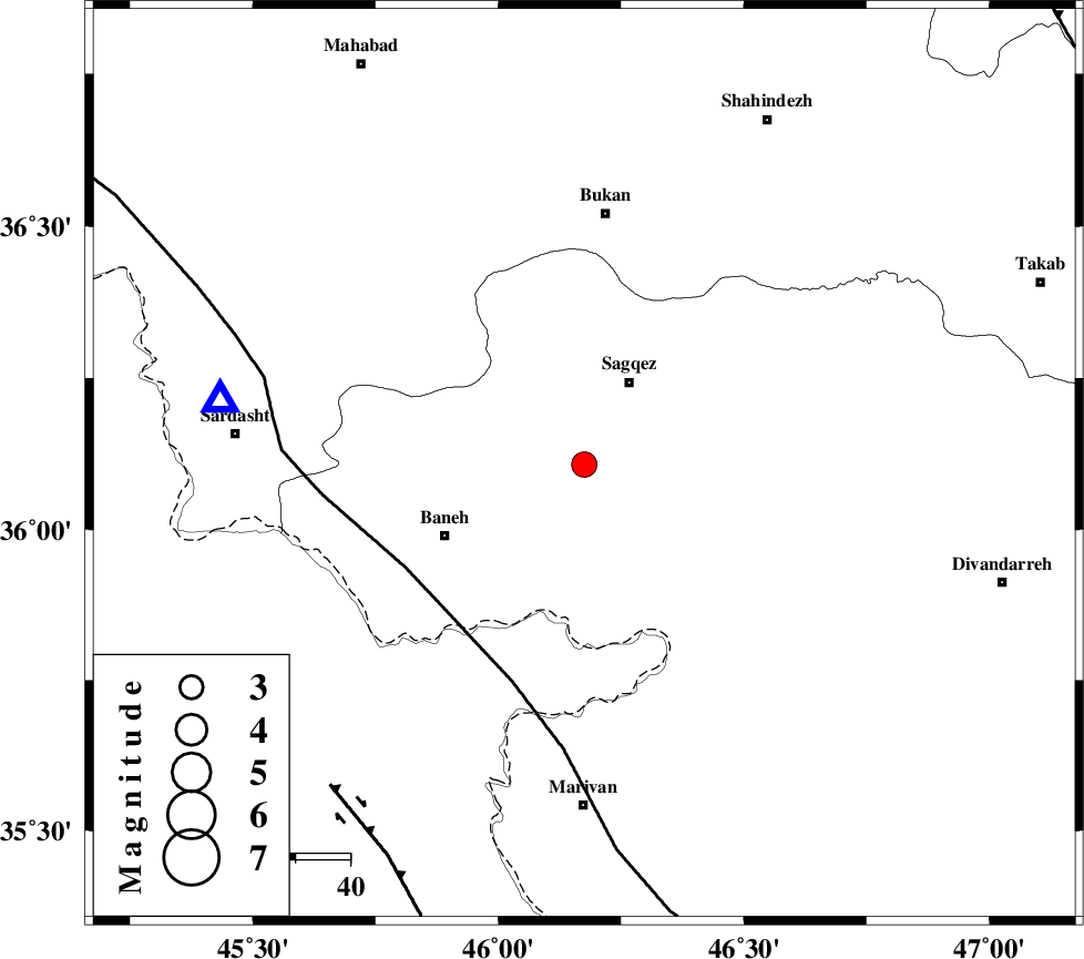
| Location | Lat:36.107 Lon: 46.175 |
| Region | Kurdistan Province, 17 km South of Saqqaz |
Nearest Cities |
|
| 12 km East of Mirdeh, Kurdistan Province | |
| 13 km North West of Hasansalaran, Kurdistan Province | |
| 17 km South of Saqqaz, Kurdistan Province | |
| 26 km South of Goltappeh, Kurdistan Province | |
| 27 km West of Saheb, Kurdistan Province | |
| Depth | 12 km |
| Agency | |
Faults within 150 km: |
|
| PIRANSHAHR_F (Length: 253 km) , Distance to epicenter: 38 km | |
| HZF4 (Length: 492 km) , Distance to epicenter: 75 km | |
| TAKHT_E_SOLAIMAN (Length: 63 km) , Distance to epicenter: 112 km | |
| Number of Phases | 6 |
| RMS | 0.7 |
| Number of Stations | 6 |
| Error in Latitude | >10.7 km |
| Error in Longitude | 10.7 km |
| Error in Depth | 13.9 km |
Download waveform in seisan format
to download seisan software Click here
to access information about IIEES stations Click here
Amplitude | ||||||||
| UID | Agency | Station | Component | Amplitude | Period | Arrival Time | Proccessing Time | Signal Clip |
| 197196 | IIEES SC | GIDE | Z | 0.01 | 1 | 2025-02-06 15:38:57 | 2025-02-16 07:08:00 | n |
| 197197 | IIEES SC | GURO | Z | 0.05 | 1 | 2025-02-06 15:39:12 | 2025-02-16 07:08:00 | n |
| 197198 | IIEES SC | ABGH | Z | 0.01 | 1 | 2025-02-06 15:39:51 | 2025-02-16 07:08:00 | n |
Phase | ||||||||||||
| Agency | Station | Component | Phase Type | Phase Quality | First Motion | Observed Arrival Time | Time Residual | Loc. Flag | Input Weight | Distance | Azimuth | |
| IIEES SC | SRSL | Z | EPg | E | 2025-02-06 15:38:20 | 1 | y | 0 | 68 | 280 | ||
| IIEES SC | SRSL | Z | ESg | E | 2025-02-06 15:38:27 | -1.1 | y | 0 | 68 | 280 | ||
| IIEES SC | ZNJK | Z | EPn | E | 2025-02-06 15:38:44 | 0.1 | y | 0 | 234 | 74 | ||
| IIEES SC | GIDE | Z | EPn | E | 2025-02-06 15:38:57 | -0.3 | y | 0 | 339 | 75 | ||
| IIEES SC | GURO | Z | EPn | E | 2025-02-06 15:39:12 | 0.6 | y | 0 | 456 | 306 | ||
| IIEES SC | ABGH | Z | EPn | E | 2025-02-06 15:39:51 | -0.2 | y | 0 | 777 | 85 | ||
کلیه حقوق مادی و معنوی این سایت متعلق به پژوهشگاه بین المللی زلزله شناسی و مهندسی زلزله می باشد.
