خانه / مشخصات زلزله
Magnitude |
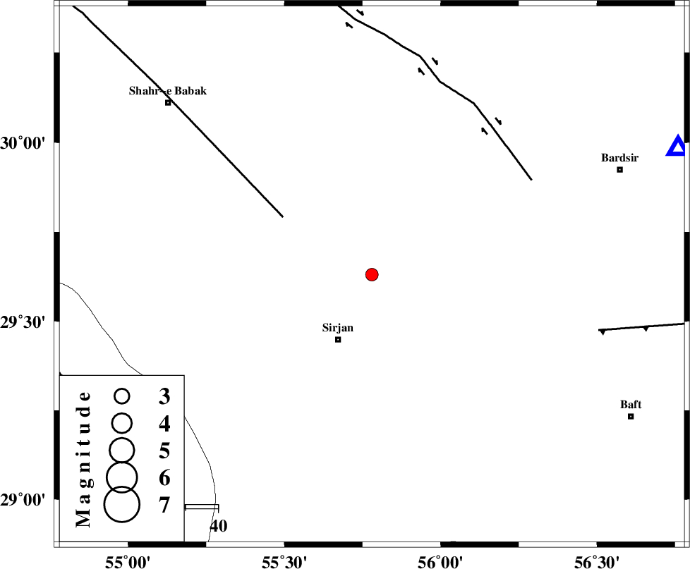
:2.6 |
| Date & Time (UTC) | 2014-02-08 09:32:12.3 |
| Date & Time (Local) | 1392/11/19 13:02:12.3 |
| Location | Lat:29.63 Lon: 55.78 |
| Region | Kerman Province, 22 km North-East of Sirjan |
Nearest Cities |
|
| 4 km of Saadatabad, Kerman Province | |
| 19 km North East of Mahmud Abad, Kerman Province | |
| 23 km North East of Sirjan, Kerman Province | |
| 25 km North East of Zeydabad, Kerman Province | |
| 26 km North East of Sharifabad, Kerman Province | |
| Depth | 18 km |
| Agency | |
Faults within 150 km: |
|
| SHAHR_E_BABAK_F2 (Length: 272 km) , Distance to epicenter: 33 km | |
| RAFSANJAN_F (Length: 129 km) , Distance to epicenter: 57 km | |
| LALEHZAR_F (Length: 52 km) , Distance to epicenter: 72 km | |
| Number of Phases | 6 |
| RMS | 0.2 |
| Number of Stations | 5 |
| Error in Latitude | >5.2 km |
| Error in Longitude | 5.4 km |
| Error in Depth | 7.8 km |
Download waveform in seisan format
to download seisan software Click here
to access information about IIEES stations Click here
Amplitude | ||||||||
| UID | Agency | Station | Component | Amplitude | Period | Arrival Time | Proccessing Time | Signal Clip |
| 91762 | IIEES | KRBR | N | 162.2 | 0.25 | 2014-02-08 09:32:45 | 2014-02-08 10:12:00 | n |
Phase | ||||||||||||
| Agency | Station | Component | Phase Type | Phase Quality | First Motion | Observed Arrival Time | Time Residual | Loc. Flag | Input Weight | Distance | Azimuth | |
| IIEES | KRBR | Z | Pg | E | 2014-02-08 09:32:30 | 0.37 | y | 103 | 67 | |||
| IIEES | YZKH | Z | Pn | E | 2014-02-08 09:33:00 | 0 | y | 327 | 340 | |||
| IIEES | BSRN | Z | Pn | E | 2014-02-08 09:33:10 | -0.15 | y | 412 | 50 | |||
| IIEES | BSRN | N | Sg | E | 2014-02-08 09:34:07 | -0.12 | y | 412 | 50 | |||
| IIEES | TABS | Z | Pn | E | 2014-02-08 09:33:17 | 0.04 | y | 464 | 16 | |||
| IIEES | ZHSF | Z | Pn | E | 2014-02-08 09:33:19 | -0.28 | y | 484 | 89 | |||
کلیه حقوق مادی و معنوی این سایت متعلق به پژوهشگاه بین المللی زلزله شناسی و مهندسی زلزله می باشد.
