خانه / مشخصات زلزله
Magnitude |
:2.8 |
| Date & Time (UTC) | 2014-02-22 12:18:24.9 |
| Date & Time (Local) | 1392/12/3 15:48:24.9 |
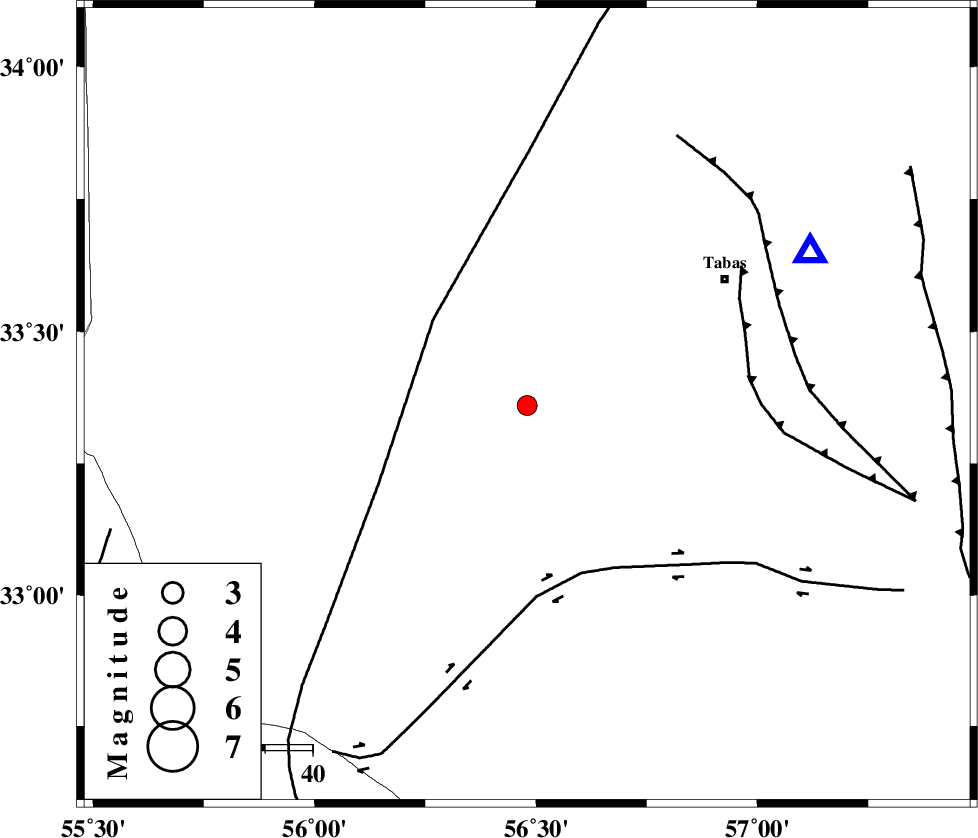
| Location | Lat:33.36 Lon: 56.48 |
| Region | Yazd Province, 50 km South-West of Tabas |
Nearest Cities |
|
| 43 km West of Kerit, Yazd Province | |
| 45 km South West of Oshtoqran, Yazd Province | |
| 49 km South West of Tabas, Yazd Province | |
| 50 km South West of Jokhvah, Yazd Province | |
| 51 km South East of Darin, Yazd Province | |
| Depth | 15 km |
| Agency | |
Faults within 150 km: |
|
| NAINI_F (Length: 342 km) , Distance to epicenter: 27 km | |
| CHESHMEH_ROSTAM_ (Length: 142 km) , Distance to epicenter: 37 km | |
| TABAS_F2 (Length: 67 km) , Distance to epicenter: 47 km | |
| Number of Phases | 3 |
| RMS | 0 |
| Number of Stations | 4 |
| Error in Latitude | >3.3 km |
| Error in Longitude | 2.3 km |
| Error in Depth | 0 km |
Download waveform in seisan format
to download seisan software Click here
to access information about IIEES stations Click here
Amplitude | ||||||||
| UID | Agency | Station | Component | Amplitude | Period | Arrival Time | Proccessing Time | Signal Clip |
| 91869 | IIEES | KRBR | E | 19.7 | 0.4 | 2014-02-22 12:20:24 | 2014-02-22 12:50:00 | n |
| 91870 | IIEES | KRBR | N | 19.4 | 0.48 | 2014-02-22 12:20:25 | 2014-02-22 12:50:00 | n |
Phase | ||||||||||||
| Agency | Station | Component | Phase Type | Phase Quality | First Motion | Observed Arrival Time | Time Residual | Loc. Flag | Input Weight | Distance | Azimuth | |
| IIEES | TABS | Z | Pg | E | 2014-02-22 12:18:36 | 0 | y | 67.8 | 61 | |||
| IIEES | YZKH | Z | Pg | E | 2014-02-22 12:18:58 | 0 | y | 207 | 239 | |||
| IIEES | BSRN | Z | Pn | E | 2014-02-22 12:19:08 | 0 | y | 292 | 121 | |||
کلیه حقوق مادی و معنوی این سایت متعلق به پژوهشگاه بین المللی زلزله شناسی و مهندسی زلزله می باشد.
