سبد خرید خالی است.
خانه / مشخصات زلزله
Magnitude |
:2.6 |
| Date & Time (UTC) | 2014-03-02 05:50:20.6 |
| Date & Time (Local) | 1392/12/11 09:20:20.6 |
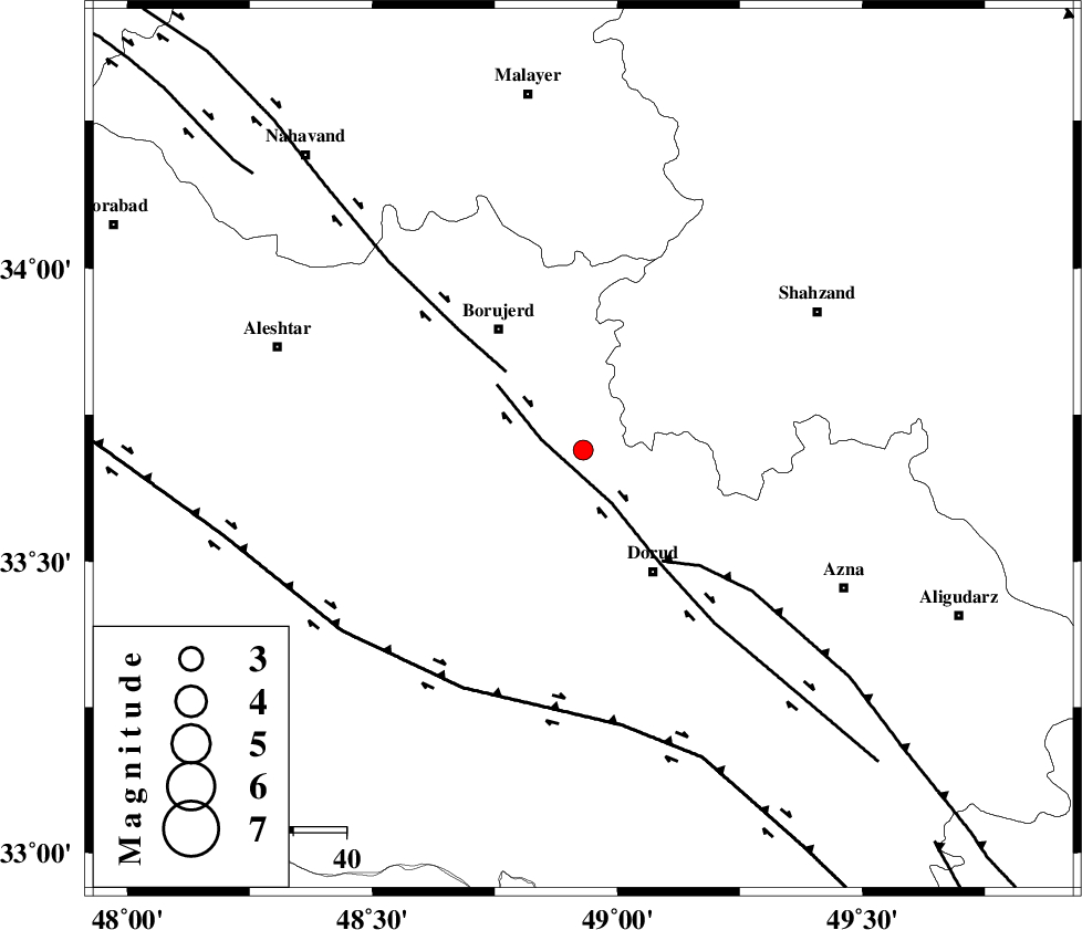
| Location | Lat:33.69 Lon: 48.93 |
| Region | Lorestan Province, 27 km North-West of Dorud |
Nearest Cities |
|
| 5 km North of Chalanchulan, Lorestan Province | |
| 9 km North of Kagheh, Lorestan Province | |
| 15 km North of Razan, Lorestan Province | |
| 17 km West of Hashian, Markazi Province | |
| 19 km North of Void, Lorestan Province | |
| Depth | 15 km |
| Agency | |
Faults within 150 km: |
|
| DORUD (Length: 100 km) , Distance to epicenter: 5 km | |
| NAHAVAND_F (Length: 102 km) , Distance to epicenter: 21 km | |
| MAIN_ZAGROS_R_F (Length: 1106 km) , Distance to epicenter: 26 km | |
| Number of Phases | 5 |
| RMS | 0.4 |
| Number of Stations | 4 |
| Error in Latitude | >4.7 km |
| Error in Longitude | 7.3 km |
| Error in Depth | 9.6 km |
Download waveform in seisan format
to download seisan software Click here
to access information about IIEES stations Click here
Amplitude | ||||||||
| UID | Agency | Station | Component | Amplitude | Period | Arrival Time | Proccessing Time | Signal Clip |
| 91899 | IIEES | SHGR | E | 147.1 | 0.37 | 2014-03-02 05:51:16 | 2014-03-02 06:24:00 | n |
| 91900 | IIEES | GHVR | N | 27.8 | 0.53 | 2014-03-02 05:51:33 | 2014-03-02 06:24:00 | n |
| 91901 | IIEES | GHVR | E | 31.5 | 0.46 | 2014-03-02 05:51:44 | 2014-03-02 06:24:00 | n |
Phase | ||||||||||||
| Agency | Station | Component | Phase Type | Phase Quality | First Motion | Observed Arrival Time | Time Residual | Loc. Flag | Input Weight | Distance | Azimuth | |
| IIEES | ASAO | Z | Pg | E | 2014-03-02 05:50:43 | -0.36 | y | 139 | 47 | |||
| IIEES | ASAO | N | Sg | E | 2014-03-02 05:51:00 | -0.19 | y | 139 | 47 | |||
| IIEES | SHGR | Z | Pg | E | 2014-03-02 05:50:49 | -0.22 | y | 176 | 184 | |||
| IIEES | SNGE | Z | Pn | E | 2014-03-02 05:50:54 | 0.06 | y | 213 | 317 | |||
| IIEES | GHVR | Z | Pn | E | 2014-03-02 05:50:57 | 0.71 | y | 231 | 67 | |||
کلیه حقوق مادی و معنوی این سایت متعلق به پژوهشگاه بین المللی زلزله شناسی و مهندسی زلزله می باشد.
