سبد خرید خالی است.
خانه / مشخصات زلزله
Magnitude |
:3.8 |
| Date & Time (UTC) | 2014-08-18 18:36:20.4 |
| Date & Time (Local) | 1393/5/27 23:06:20.4 |
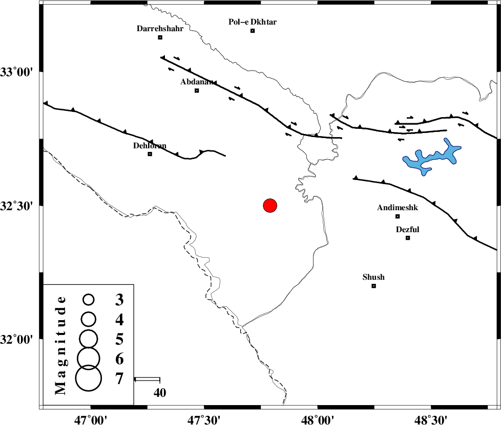
| Location | Lat:32.5 Lon: 47.79 |
| Region | Ilam Province, 52 km West of Andimeshk |
Nearest Cities |
|
| 41 km East of Musian, Ilam Province | |
| 47 km South West of Hoseinieh, Khoozestan Province | |
| 49 km South East of Sarabbagh, Ilam Province | |
| 51 km South West of Bidruyeh, Khoozestan Province | |
| 53 km North West of Andimeshk, Khoozestan Province | |
| Depth | 18 km |
| Agency | |
Faults within 150 km: |
|
| MFF6 (Length: 144 km) , Distance to epicenter: 28 km | |
| BALARUD_F_Z1 (Length: 87 km) , Distance to epicenter: 32 km | |
| DEZFUL_EMBAYMENT (Length: 228 km) , Distance to epicenter: 36 km | |
| Number of Phases | 5 |
| RMS | 0.1 |
| Number of Stations | 4 |
| Error in Latitude | >4.7 km |
| Error in Longitude | 7.1 km |
| Error in Depth | 13.2 km |
Download waveform in seisan format
to download seisan software Click here
to access information about IIEES stations Click here
Amplitude | ||||||||
| UID | Agency | Station | Component | Amplitude | Period | Arrival Time | Proccessing Time | Signal Clip |
| 93038 | IIEES | SHGR | E | 2850.6 | 0.6 | 2014-08-18 18:37:14 | 2014-08-18 07:59:00 | n |
| 93039 | IIEES | SHGR | N | 2779 | 0.68 | 2014-08-18 18:37:17 | 2014-08-18 07:59:00 | n |
Phase | ||||||||||||
| Agency | Station | Component | Phase Type | Phase Quality | First Motion | Observed Arrival Time | Time Residual | Loc. Flag | Input Weight | Distance | Azimuth | |
| IIEES | SHGR | Z | Pn | E | 2014-08-18 18:36:40 | -0.02 | y | 104 | 114 | |||
| IIEES | KHMZ | Z | Pn | E | 2014-08-18 18:36:58 | 0.18 | y | 245 | 55 | |||
| IIEES | SNGE | Z | Pn | E | 2014-08-18 18:37:04 | 0.04 | y | 291 | 352 | |||
| IIEES | ASAO | Z | Pn | E | 2014-08-18 18:37:05 | -0.22 | y | 308 | 42 | |||
| IIEES | ASAO | N | Sg | E | 2014-08-18 18:37:47 | 0 | y | 308 | 42 | |||
کلیه حقوق مادی و معنوی این سایت متعلق به پژوهشگاه بین المللی زلزله شناسی و مهندسی زلزله می باشد.
