سبد خرید خالی است.
خانه / مشخصات زلزله
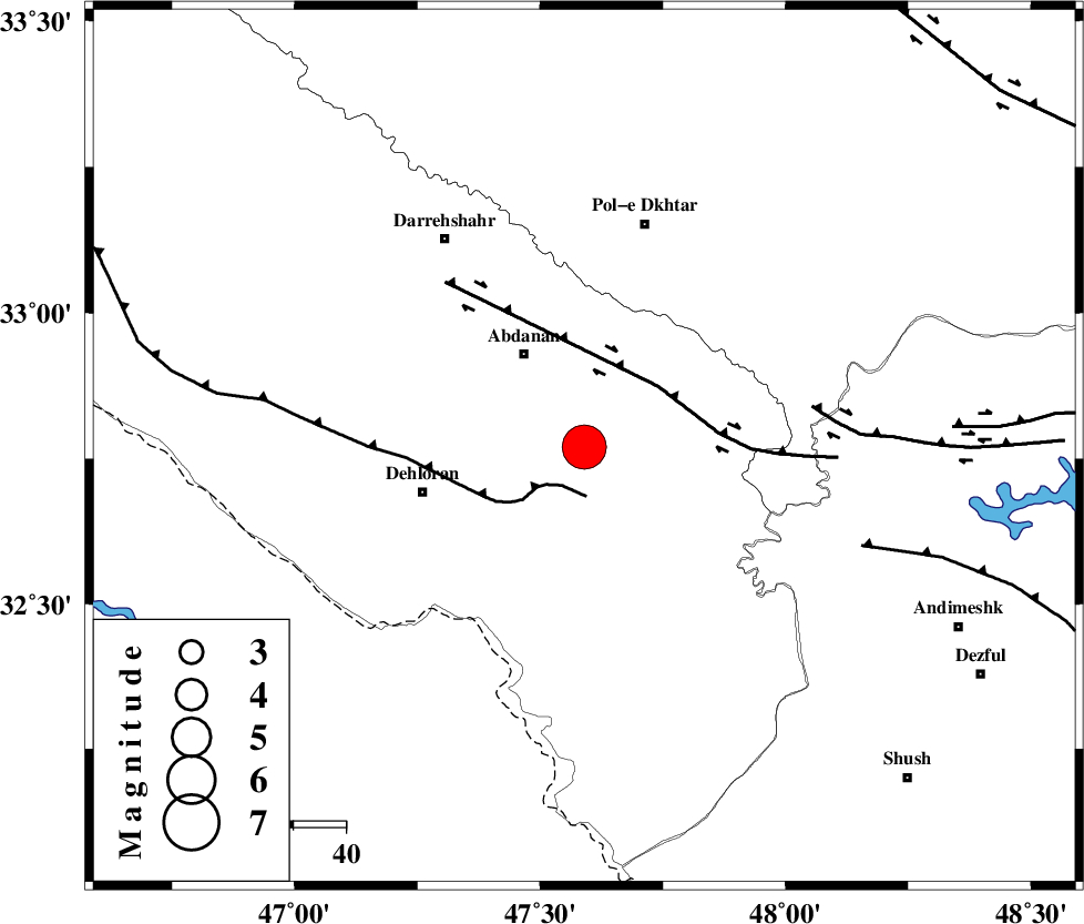
Magnitude |
:5.6 |
| Date & Time (UTC) | 2014-08-18 11:51:35.5 |
| Date & Time (Local) | 1393/5/27 16:21:35.5 |
| Location | Lat:32.77 Lon: 47.59 |
| Region | Ilam Province, 22 km South-East of Abdanan |
Nearest Cities |
|
| 14 km South of Sarabbagh, Ilam Province | |
| 21 km South East of Abdanan, Ilam Province | |
| 32 km North East of Dehloran, Ilam Province | |
| 33 km North East of Musian, Ilam Province | |
| 37 km South of Sarab hammam, Lorestan Province | |
| Depth | 14 km |
| Agency | |
Faults within 150 km: |
|
| MFF6 (Length: 144 km) , Distance to epicenter: 9 km | |
| BALARUD_F_Z1 (Length: 87 km) , Distance to epicenter: 18 km | |
| BALARUD_F_Z3 (Length: 53 km) , Distance to epicenter: 44 km | |
| Number of Phases | 5 |
| RMS | 0.2 |
| Number of Stations | 5 |
| Error in Latitude | >4.3 km |
| Error in Longitude | 6.5 km |
| Error in Depth | 10.2 km |
Download waveform in seisan format
to download seisan software Click here
to access information about IIEES stations Click here
Amplitude | ||||||||
| UID | Agency | Station | Component | Amplitude | Period | Arrival Time | Proccessing Time | Signal Clip |
| 93066 | IIEES | ASAO | E | 9049.5 | 0.76 | 2014-08-18 11:53:15 | 2014-08-18 10:55:00 | n |
| 93067 | IIEES | CHBR | E | 63.4 | 0.48 | 2014-08-18 11:54:59 | 2014-08-18 10:55:00 | n |
Phase | ||||||||||||
| Agency | Station | Component | Phase Type | Phase Quality | First Motion | Observed Arrival Time | Time Residual | Loc. Flag | Input Weight | Distance | Azimuth | |
| IIEES | SHGR | Z | Pg | E | 2014-08-18 11:51:57 | -0.14 | y | 135 | 122 | |||
| IIEES | KHMZ | Z | Pn | E | 2014-08-18 11:52:14 | 0.41 | y | 246 | 63 | |||
| IIEES | KHMZ | N | Sg | E | 2014-08-18 11:52:45 | -0.12 | y | 246 | 63 | |||
| IIEES | SNGE | Z | Pn | E | 2014-08-18 11:52:15 | -0.17 | y | 259 | 355 | |||
| IIEES | ASAO | Z | Pn | E | 2014-08-18 11:52:20 | 0.02 | y | 300 | 48 | |||
کلیه حقوق مادی و معنوی این سایت متعلق به پژوهشگاه بین المللی زلزله شناسی و مهندسی زلزله می باشد.
