خانه / مشخصات زلزله
Magnitude |
:2.8 |
| Date & Time (UTC) | 2015-03-03 08:17:53.4 |
| Date & Time (Local) | 1393/12/12 11:47:53.4 |
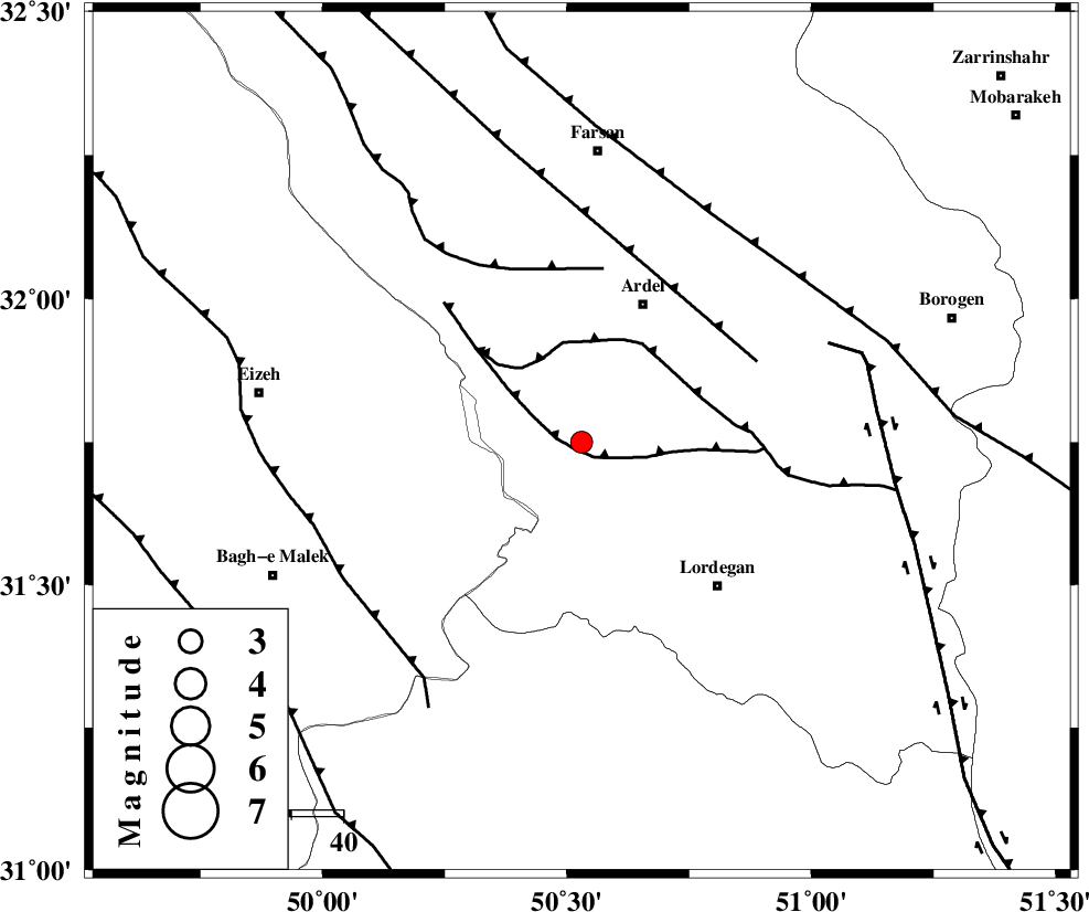
| Location | Lat:31.75 Lon: 50.53 |
| Region | Chaharmahal Bakhtiari Province, 29 km South-West of Ardel |
Nearest Cities |
|
| 2 km North of Sarkhun, Chaharmahal Bakhtiari Province | |
| 20 km South of Dupelan, Chaharmahal Bakhtiari Province | |
| 24 km North East of Dehdez, Khoozestan Province | |
| 28 km North West of Armand-e olia, Chaharmahal Bakhtiari Province | |
| 29 km South West of Naghan, Chaharmahal Bakhtiari Province | |
| Depth | 18 km |
| Agency | |
Faults within 150 km: |
|
| SABZKUH_F (Length: 67 km) , Distance to epicenter: 2 km | |
| DOPOLAN_F (Length: 107 km) , Distance to epicenter: 18 km | |
| ZARDKUH_F (Length: 139 km) , Distance to epicenter: 34 km | |
| Number of Phases | 6 |
| RMS | 0.2 |
| Number of Stations | 5 |
| Error in Latitude | >3.2 km |
| Error in Longitude | 3.7 km |
| Error in Depth | 8.7 km |
Download waveform in seisan format
to download seisan software Click here
to access information about IIEES stations Click here
Amplitude | ||||||||
| UID | Agency | Station | Component | Amplitude | Period | Arrival Time | Proccessing Time | Signal Clip |
| 95152 | IIEES | SHGR | E | 153.2 | 0.47 | 2015-03-03 08:18:55 | 2015-03-03 08:49:00 | n |
| 95153 | IIEES | SHGR | N | 155.8 | 0.47 | 2015-03-03 08:18:58 | 2015-03-03 08:49:00 | n |
| 95154 | IIEES | ASAO | N | 24.5 | 0.6 | 2015-03-03 08:19:29 | 2015-03-03 08:49:00 | n |
Phase | ||||||||||||
| Agency | Station | Component | Phase Type | Phase Quality | First Motion | Observed Arrival Time | Time Residual | Loc. Flag | Input Weight | Distance | Azimuth | |
| IIEES | SHGR | Z | Pg | E | 2015-03-03 08:18:20 | -0.25 | y | 168 | 284 | |||
| IIEES | SHGR | N | Sg | E | 2015-03-03 08:18:41 | 0.24 | y | 168 | 284 | |||
| IIEES | KHMZ | Z | Pn | E | 2015-03-03 08:18:28 | -0.24 | y | 227 | 347 | |||
| IIEES | NASN | Z | Pn | E | 2015-03-03 08:18:31 | 0.04 | y | 244 | 61 | |||
| IIEES | ASAO | N | Sg | E | 2015-03-03 08:19:21 | 0.06 | y | 314 | 352 | |||
| IIEES | YZKH | Z | Pn | E | 2015-03-03 08:18:49 | 0.18 | y | 390 | 78 | |||
کلیه حقوق مادی و معنوی این سایت متعلق به پژوهشگاه بین المللی زلزله شناسی و مهندسی زلزله می باشد.
