خانه / مشخصات زلزله
Magnitude |
:2.5 |
| Date & Time (UTC) | 2015-05-11 05:04:49.3 |
| Date & Time (Local) | 1394/2/21 09:34:49.3 |
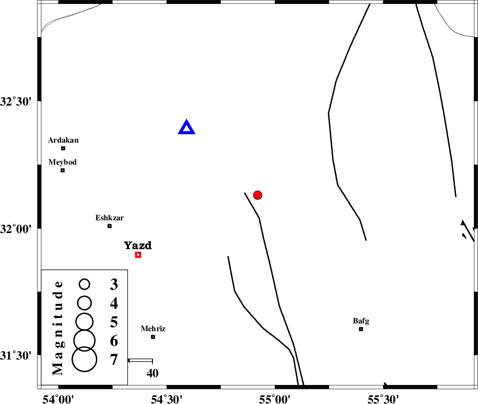
| Location | Lat:32.13 Lon: 54.92 |
| Region | Yazd Province, 58 km North-East of Yazd |
Nearest Cities |
|
| 34 km South East of Kharaneq, Yazd Province | |
| 58 km North East of Yazd, Yazd Province | |
| 61 km North East of Mohammadabad, Yazd Province | |
| 65 km North East of Kheyrabad, Yazd Province | |
| 66 km North East of Ashkezar, Yazd Province | |
| Depth | 14 km |
| Agency | |
Faults within 150 km: |
|
| ANAR_F (Length: 91 km) , Distance to epicenter: 6 km | |
| ANAR_F (Length: 127 km) , Distance to epicenter: 30 km | |
| POSHT_E_BADAM_F (Length: 128 km) , Distance to epicenter: 35 km | |
| Number of Phases | 6 |
| RMS | 0.2 |
| Number of Stations | 4 |
| Error in Latitude | >3.9 km |
| Error in Longitude | 4.6 km |
| Error in Depth | 4.6 km |
Download waveform in seisan format
to download seisan software Click here
to access information about IIEES stations Click here
Amplitude | ||||||||
| UID | Agency | Station | Component | Amplitude | Period | Arrival Time | Proccessing Time | Signal Clip |
| 95645 | IIEES | YZKH | N | 353.9 | 0.28 | 2015-05-11 05:05:03 | 2015-05-11 06:33:00 | n |
| 95646 | IIEES | KRBR | N | 30.6 | 0.45 | 2015-05-11 05:06:17 | 2015-05-11 06:33:00 | n |
Phase | ||||||||||||
| Agency | Station | Component | Phase Type | Phase Quality | First Motion | Observed Arrival Time | Time Residual | Loc. Flag | Input Weight | Distance | Azimuth | |
| IIEES | YZKH | Z | Pg | E | 2015-05-11 05:04:57 | -0.11 | y | 42.1 | 313 | |||
| IIEES | YZKH | E | Sg | E | 2015-05-11 05:05:02 | -0.13 | y | 42.1 | 313 | |||
| IIEES | NASN | Z | P | E | 2015-05-11 05:05:23 | 0.25 | y | 212 | 291 | |||
| IIEES | KRBR | Z | Pn | E | 2015-05-11 05:05:34 | 0.2 | y | 296 | 143 | |||
| IIEES | KRBR | E | Sg | E | 2015-05-11 05:06:12 | -0.24 | y | 296 | 143 | |||
| IIEES | BSRN | Z | Pn | E | 2015-05-11 05:05:46 | 0.05 | y | 398 | 92 | |||
کلیه حقوق مادی و معنوی این سایت متعلق به پژوهشگاه بین المللی زلزله شناسی و مهندسی زلزله می باشد.
