| Prel. Rep. | Date | Time(UTC) | Time(Local) | Lat. | Lon. | Depth | Mag. | Region | Waveform |
|
|
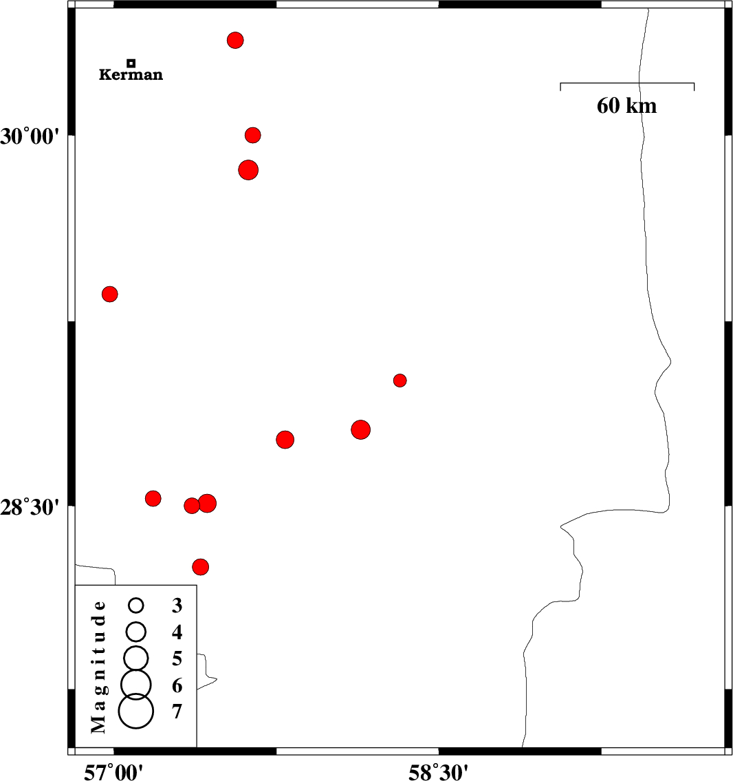
2019/10/14
|
04:59:58.6
|
08:29:58.6
| 29.01 | 58.32 | 14 |
ML2.7
|
Kerman Province, 12 km of Bam | |
|
|
2019/10/12
|
05:07:10.7
|
08:37:10.7
| 30 | 57.64 | 14 |
ML3.2
|
Kerman Province, 63 km South-East of Kerman | |
|
|
2019/10/07
|
01:45:35.6
|
05:15:35.6
| 30.38 | 57.56 | 5 |
ML3.4
|
Kerman Province, 47 km -East of Kerman | |
|
|
2019/10/05
|
12:50:35.2
|
16:20:35.2
| 29.36 | 56.98 | 10 |
ML3.3
|
Kerman Province, 39 km North-East of Baft | |
|
|
2019/10/02
|
11:09:59.3
|
14:39:59.3
| 28.25 | 57.4 | 10 |
ML3.4
|
Kerman Province, 44 km North-West of Kahnuj | |
|
|
2019/09/28
|
23:53:16.2
|
03:23:16.2
| 28.81 | 58.14 | 14 |
ML3.9
|
Kerman Province, 39 km South-West of Bam | |
|
|
2019/09/23
|
12:23:17.2
|
15:53:17.2
| 28.5 | 57.36 | 14 |
ML3.3
|
Kerman Province, 42 km South-West of Jiroft | |
|
|
2019/09/23
|
12:04:05.2
|
15:34:05.2
| 28.51 | 57.43 | 14 |
ML3.8
|
Kerman Province, 35 km South-West of Jiroft | |
|
|
2019/09/19
|
11:07:25.8
|
15:37:25.8
| 28.53 | 57.18 | 14 |
ML3.3
|
Kerman Province, 57 km South-West of Jiroft | |
|
|
2019/09/19
|
07:24:15.4
|
11:54:15.4
| 29.86 | 57.62 | 10 |
ML4.1
|
Kerman Province, 71 km South-East of Kerman | |
|
|
2019/09/16
|
22:58:07.7
|
03:28:07.7
| 28.77 | 57.79 | 12 |
ML3.6
|
Kerman Province, 12 km North of Jiroft | |