| Prel. Rep. | Date | Time(UTC) | Time(Local) | Lat. | Lon. | Depth | Mag. | Region | Waveform |
|
|
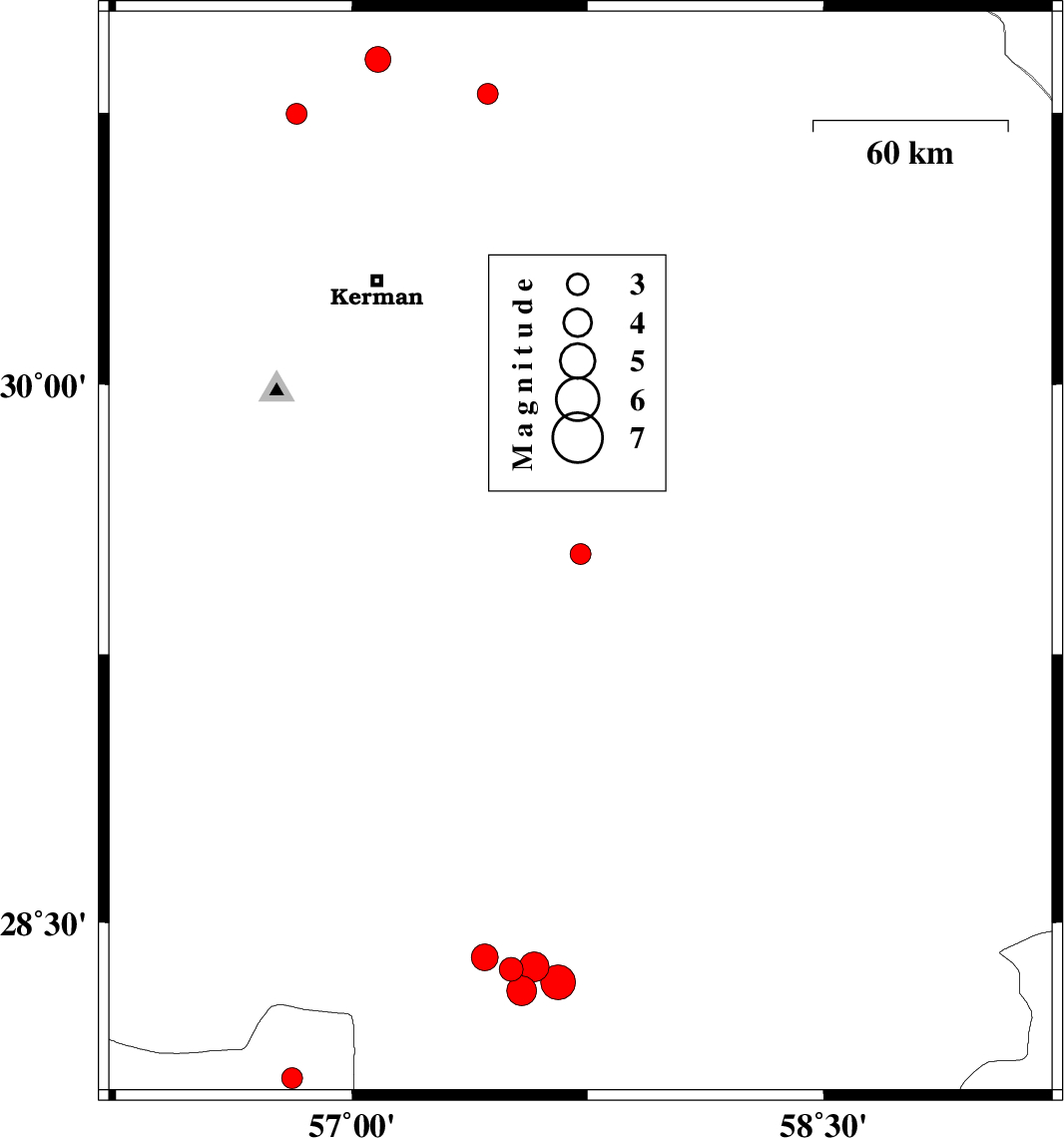
2021/08/21
|
21:21:07.2
|
01:51:07.2
| 29.529 | 57.727 | 12 |
ML3
|
Kerman Province, 96 km North of Jiroft | |
|
|
2021/08/14
|
09:15:02.7
|
13:45:02.7
| 28.368 | 57.507 | 9 |
ML3.4
|
Kerman Province, 40 km South-West of Jiroft | |
|
|
2021/08/13
|
17:27:31.2
|
21:57:31.2
| 28.308 | 57.54 | 10 |
ML4.2
|
Kerman Province, 43 km North-West of Kahnuj | |
|
|
2021/08/12
|
14:52:30.6
|
19:22:30.6
| 28.375 | 57.58 | 10 |
ML4.2
|
Kerman Province, 36 km South-West of Jiroft | |
|
|
2021/08/12
|
12:24:06.2
|
16:54:06.2
| 28.332 | 57.655 | 16 |
ML5
|
Kerman Province, 38 km South of Jiroft | |
|
|
2021/08/12
|
12:11:05.2
|
16:41:05.2
| 28.402 | 57.422 | 9 |
ML3.8
|
Kerman Province, 43 km South-West of Jiroft | |
|
|
2021/08/03
|
17:27:50.3
|
21:57:50.3
| 30.896 | 57.083 | 12 |
ML3.7
|
Kerman Province, 50 km -East of Zarand | |
|
|
2021/08/02
|
22:47:38.4
|
03:17:38.4
| 30.801 | 57.432 | 12 |
ML3
|
Kerman Province, 66 km North-East of Kerman | |
|
|
2021/07/27
|
17:51:09.5
|
22:21:09.5
| 30.747 | 56.824 | 12 |
ML3
|
Kerman Province, 25 km -East of Zarand | |
|
|
2021/07/24
|
09:19:52.0
|
13:49:52.0
| 28.062 | 56.81 | 12 |
ML3
|
Hormozgan Province, 88 km North-West of Kahnuj | |