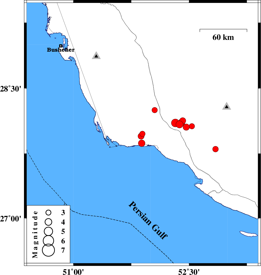
| Prel. Rep. | Date | Time(UTC) | Time(Local) | Lat. | Lon. | Depth | Mag. | Region | Waveform |
|
|
2025/02/11
|
04:40:19.4
|
08:10:19.4
| 28.25 | 52.054 | 12 |
ML3.2
|
Bushehr Province, 47 km North of Bandar-e kangan | |
|
|
2025/02/11
|
04:29:14.0
|
07:59:14.0
| 27.977 | 51.895 | 12 |
ML3.2
|
Bushehr Province, 23 km North-West of Bandar-e kangan | |
|
|
2025/02/10
|
05:53:44.8
|
09:23:44.8
| 27.869 | 51.885 | 12 |
ML3.9
|
Bushehr Province, 18 km -West of Bandar-e kangan | |
|
|
2025/02/07
|
22:19:52.8
|
01:49:52.8
| 27.8 | 52.843 | 12 |
ML3.4
|
Fars Province, 28 km North of Mehr | |
|
|
2025/02/05
|
22:45:50.7
|
02:15:50.7
| 28.055 | 52.463 | 12 |
ML3.8
|
Fars Province, 29 km North-East of Jam | |
|
|
2025/02/05
|
20:24:38.1
|
23:54:38.1
| 28.086 | 52.376 | 12 |
ML4.3
|
Fars Province, 29 km North of Jam | |
|
|
2025/02/05
|
13:17:29.4
|
16:47:29.4
| 28.128 | 52.418 | 14 |
ML3.6
|
Fars Province, 34 km North-East of Jam | |
|
|
2025/02/05
|
07:49:56.2
|
11:19:56.2
| 28.11 | 52.403 | 12 |
ML4
|
Fars Province, 32 km North of Jam | |
|
|
2025/02/04
|
15:29:33.1
|
18:59:33.1
| 27.95 | 51.877 | 12 |
ML3.7
|
Bushehr Province, 23 km North-West of Bandar-e kangan | |
|
|
2025/02/04
|
14:17:42.7
|
17:47:42.7
| 28.103 | 52.322 | 9 |
ML4.6
|
Fars Province, 30 km North of Jam | |
|
|
2025/02/04
|
13:38:10.8
|
17:08:10.8
| 28.064 | 52.536 | 16 |
ML3.2
|
Fars Province, 34 km North-East of Jam | |