خانه / زمین لرزه های اخیر
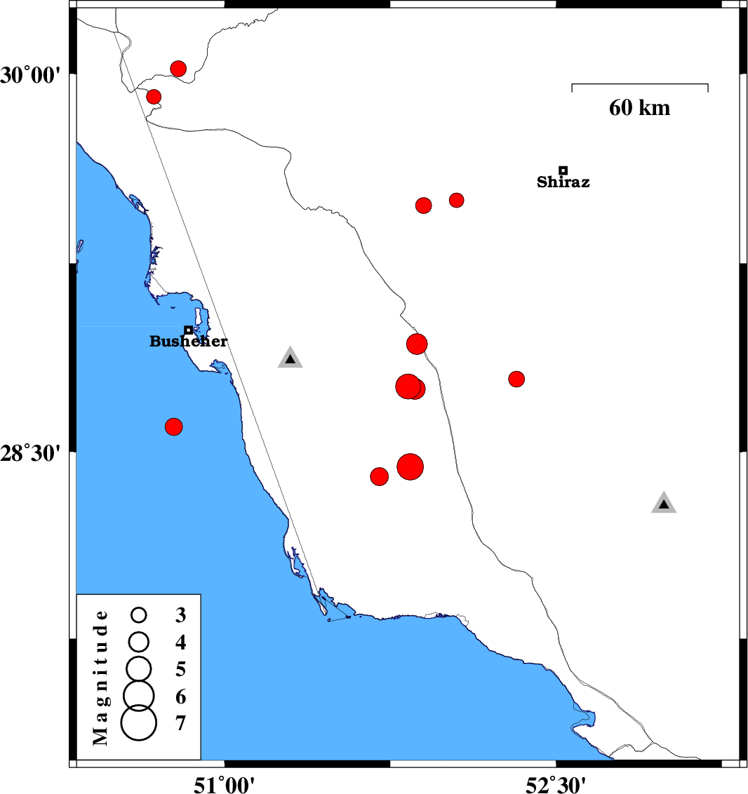
| Prel. Rep. | Date | Time(UTC) | Time(Local) | Lat. | Lon. | Depth | Mag. | Region | Waveform |
| 2015/01/01 | 08:49:54.2 | 12:19:54.2 | 28.76 | 51.83 | 17 | ML:5.1 | Bushehr Province, 28 km South-West of Farashband | ||
| 2014/12/31 | 10:06:11.1 | 13:36:11.1 | 28.79 | 52.32 | 17 | ML:3.2 | Fars Province, 24 km East of Farashband | ||
| 2014/12/30 | 22:10:19.0 | 01:40:19.0 | 28.75 | 51.86 | 11 | ML:4.3 | Bushehr Province, 26 km South-West of Farashband | ||
| 2014/12/30 | 13:23:22.3 | 16:53:22.3 | 28.4 | 51.7 | 16 | ML:3.6 | Bushehr Province, 42 km South-East of Khormog | ||
| 2014/12/30 | 05:23:05.1 | 08:53:05.1 | 28.93 | 51.87 | 16 | ML:4.3 | Bushehr Province, 22 km West of Farashband | ||
| 2014/12/30 | 04:19:33.4 | 07:49:33.4 | 28.44 | 51.84 | 28 | ML:5.4 | Bushehr Province, 53 km South-West of Farashband | ||
| 2014/12/29 | 13:00:08.1 | 16:30:08.1 | 28.6 | 50.77 | 17 | ML:3.5 | Persian Gulf, 43 km South of Busheher | ||
| 2014/12/26 | 19:51:46.4 | 23:21:46.4 | 29.48 | 51.9 | 6 | ML:3.3 | Fars Province, 29 km South-East of Kazerun | ||
| 2014/12/21 | 09:42:44.1 | 13:12:44.1 | 29.91 | 50.68 | 14 | ML:3 | Fars Province, 40 km North-East of Bandar-e genaveh | ||
| 2014/12/07 | 14:37:35.5 | 18:07:35.5 | 30.02 | 50.79 | 14 | ML:3.2 | Kohkiluieh va boyerahmad Province, 38 km South of Dogonbadan | ||
| 2014/12/03 | 09:41:26.2 | 13:11:26.2 | 29.5 | 52.05 | 15 | ML:2.9 | Fars Province, 40 km South-East of Kazerun |
کلیه حقوق مادی و معنوی این سایت متعلق به پژوهشگاه بین المللی زلزله شناسی و مهندسی زلزله می باشد.
